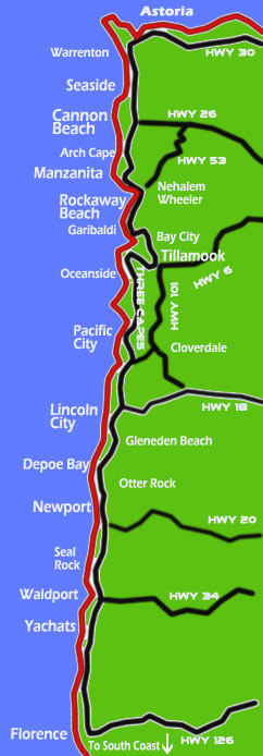
Oregon Coast Maps and Mileage Chart - Map and Miles Between Towns, Best Routes
Find mileage from Portland, Salem, Corvallis, Albany and Eugene to Oregon coast towns, as well as between coastal towns. Find the best routes to the Oregon coast from the valley.
Mileage charts are approximate and can change depending on what route is taken to the Oregon coast. They are based on mileage road signs in each town.
Click on the links for further maps of each area and detailed mileage, distance between beaches.
Here for Oregon Coast Highway, Coast Range Passes Traffic, Road Conditions
Miles From Portland to….
To Seaside – 79 miles
To Cannon Beach – 79 miles
To Manzanita – 110 miles
To Tillamook (via Hwy 6) – 74 miles
To Pacific City – 94 miles
To Lincoln City – 88 miles (via Hwy 18)
To Depoe Bay – 100 miles
To Newport – 114 miles
To Yachats – 140 miles
To Florence – 164 miles
Note: Portland to Manzanita route can also be Hwy 26 to Hwy 53, about 70 miles, which then takes about 25 miles to Manzanita, Wheeler or Nehalem. However, due to the winding nature of 53, it still takes a little longer than going straight down 101, depending on traffic on 101.
Mileage from Corvallis to….
To Depoe Bay – 59 miles
To Newport – 50 miles
Mileage from Salem to…
To Seaside - 119 miles
To Pacific City - 80 miles
To Lincoln City – 57 miles
To Depoe Bay - 75 miles
To Newport - 83 miles
To Florence – 118 miles
Mileage from Eugene to….
To Florence – 50 miles
To Newport – 92 miles
To Lincoln City – 122 miles
To Tillamook – 130 miles
To Seaside – 168 miles
To Astoria – 199 miles

MILEAGE FROM COAST TOWN TO COAST TOWN
(click on links for futher details, more maps, more mileage, distances between beaches)
Astoria to Florence - 184 miles
Astoria and Washington coast to Seaside - 17 miles
Astoria to Yachats - 158 miles
Astoria to Lincoln City - 110 miles
Astoria to Newport - 135 miles
Astoria to Tillamook - 66 miles
Seaside to Cannon Beach - 9 miles
Seaside to Manzanita - 27 miles
Seaside to Tillamook - 49 miles
Seaside to Newport - 128 miles
Seaside to Washington coast (Astoria) - 17 miles
Seaside to Lincoln City - 103 miles
Seaside to Yachats - 161 miles
Cannon Beach to Manzanita - 14 miles
Cannon Beach to Rockaway Beach - 26 miles
Cannon Beach to Tillamook - 36 miles
Cannon Beach to Pacific City - 64 miles (via 101 and then Sand Lake Rd)
Cannon Beach to Lincoln City - 84 miles
Cannon Beach to Depoe Bay - 96 miles
Cannon Beach to Newport - 108 miles
Cannon Beach to Yachats - 132 miles
Cannon Beach to Florence - 158 miles
Manzanita to Seaside - 27 miles
Manzanita to Rockaway Beach - 12 miles
Manzanita to Lincoln City - 75 miles
Manzanita to Newport (and Newport Map) - 105 miles
Wheeler / Nehalem to Newport - 100 miles
Manzanita and Nehalem to Tillamook - appx 27 miles
Rockaway Beach mileage: subtract appx 12 miles from Manzanita mileage for any town south of Rockaway Beach
Garibaldi to Tillamook- 10 miles
Tillamook to Seaside - 49 miles
Tillamook to Pacific City - 20 miles
Tillamook to Lincoln City - 44 miles
Tillamook to Florence - 119 miles
Oceanside to Tillamook - 9 miles
Oceanside to Pacific City - 23 miles
Note: for further Oceanside mileage, the village is along the Three Capes Route. See Pacific City mileage to compare to towns southward; see Tillamook mleage for towns north of Oceanside
Three Capes Loop - 24 miles (appx 40-minute drive, includes Oceanside, Cape Meares, Cape Lookout, Netarts, Tierra Del Mar and Pacific City)
Hwy 101 Inland: includes Hebo, Cloverdale and Tillamook and veers inland for about 20 miles (between Pacific City / Neskowin and Tillamook)
Pacific City to Seaside- 70 miles (appx)
Pacific City to Lincoln City - 24 miles
Pacific City to Lincoln City - 24 miles
Pacific City to Cannon Beach - 64 miles
Note: use Tillamook as a nearby reference point for mileage going north; use Lincoln City as a reference for going south
Lincoln City to Depoe Bay - 13 miles
Lincoln City to Tillamook - 44 miles
Lincoln City to Seaside - 103 miles
Lincoln City to Astoria - 110 miles
Lincoln City to Pacific City - 24 miles
Lincoln City to Newport - 24 miles
Note: Neskowin is about 15 miles north of Lincoln City and 5 miles south of Pacific City
Depoe Bay mileage: add about 13 miles for mileage of all towns northward (this area includes Gleneden Beach)
Newport to Depoe Bay - 13 miles
Newport to Astoria - 145 miles
Newport to Seaside - 128 miles
Newport to Cannon Beach - 109 miles
Newport to Manzanita - 98 miles
Newport to Lincoln City - 24 miles
Newport to Florence - 65 miles
Newport to Yachats - 25 miles
Waldport to Newport - 16 miles
Waldport to Yachats - 6 miles
Waldport to Seal Rock - appx 10 miles
Note: for Waldport mileage add appx 16 miles to towns north of Newport
Yachats to Astoria - 158 miles
Yachats to Cannon Beach - 132 miles
Yachats to Manzanita - 118 miles
Yachats to Newport - 25 miles
Yachats to Florence - 25 miles
Note: for Yachats mileage add appx 25 miles to towns north of Newport
For details and mileage between beaches in that area between Yachats and Florence, see the Upper Lane County Virtual Tour.
BEST ROUTES TO OREGON COAST
Best routes from Portland to coast:
To Astoria, Seaside, Cannon Beach and Manzanita – take Hwy 26 to coast.
Note: Portland to Manzanita route can also be Hwy 26 to Hwy 53, about 70 miles, which then takes about 25 miles to Manzanita, Wheeler or Nehalem. However, due to the winding nature of 53, it still takes a little longer than going straight down 101, depending on traffic on 101.
To Manzanita, Rockaway Beach and Tillamook Bay and Pacific City - Take Hwy 6 (exit is on 26 just west of Hillsboro).
To Lincoln City, Depoe Bay, Newport, Yachats and Florence – take Hwy 18 west, which takes about two hours to Lincoln City.
Or take I-5 down to Salem (appx 45 miles), then take Hwy 20 west until it becomes Hwy 18. This can shave off 15 minutes to as much as a half hour to Lincoln City.
Or take I-5 south to Corvallis, then Hwy 20 west to Newport. This can also shave off some time to Newport or Yachats.
For Florence: either take the scenic route down 101, or take I-5 down to Eugene (about 110 miles), then take Hwy 126 to Florence.
Best routes from Salem to Oregon Coast:
To Astoria, Seaside, Cannon Beach and Manzanita – take I-5 north to Portland, then take 217 exit near Lake Oswego, following “Oregon Beaches” sign – take 217 to Hwy 26, then to coast.
To Manzanita, Rockaway and Tillamook Bay - take I-5 to Hwy 217 again, then to Hwy 26 again, but this time take Hwy 6 exit just outside Hillsboro. Take Hwy 6 straight to Tillamook: Manzanita and Rockaway are just north. Oceanside, Tillamook and Pacific Ctiy are west or southwest.
To Tillamook, Pacific City, Lincoln City, Depoe Bay and Newport and Waldport – take Hwy 22 west, which eventually turn into Hwy 18 heading over the coast range to the beach.
To Newport, Yachats and Florence – You can also take I-5 south to Corvallis, then Hwy 20 west to Newport.
Or take I-5 down to Eugene (appx 60 miles), then take Hwy 126 to Florence.
Note: Hwy 34 from Corvallis to Newport is extremely winding and long. It is, however, a stunning scenic route, if you have the time.
Best Routes from Eugene or Corvallis to Oregon Coast:
Take Hwy 126 from Eugene to Florence. For Corvallis / Albany: use above directions
Best Routes to South Oregon Coast:
To Reedsport, Oregon National Dunes Rec Area or Coos Bay, take Oregon Highway 126 to Florence and then southward.
South of Eugene at Drain: take Hwy 99/38 towards Drain and Elkton, then Highway 38 to Reedsport. Head southward to Coos Bay (26 miles), Bandon, Port Orford, Gold Beach, Brookings.
FROM SOUTHERN OREGON
Take Hwy 42W from near Winston (Coos Bay-Roseburg Hwy) to Bandon. From there head north to Coos Bay or south to Port Orford, Langlois, Nesika, Gold Beach, Brookings.
Note: if coming from California, Medford, Roseburg, etc. and you're heading north of Coos Bay to north Oregon coast, it will be easier to take I-5 northward until you reach one of the north Coast Range highways above.
Hwy 199 runs a long route between Grants Pass and the northern California coast. This may be faster if you're coming from the south to Brookings, Gold Beach.
Individual Oregon Coast Maps
- South Oregon Coast Map, Travel Destinations
- Florence Virtual Tour, Map
- Between Florence and Yachats, Upper Lane County Map
- Yachats, Oregon Map, Virtual Tour, Visitor Info
- Waldport, Seal Rock Map, Virtual Tour, Visitor Info
- Newport Oregon Map, Virtual Tour, Visitor Info
- Find distance, mileage between Newport beaches
- Depoe Bay, Oregon Map, Virtual Tour, Visitor
- Lincoln City, Oregon Map, Virtual Tour, Visitor Details
- Find distance, mileage between Lincoln City beaches
- Three Capes Map: Oceanside Map
- Three Capes Map: Pacific City Map
- Tillamook Map, Virtual Tour, Visitor Info
- Garibaldi Map, Virtual Tour, Visitor Info
- Rockaway Beach, Oregon Map, Virtual Tour, Visitor Info
- Find mileage between beaches around Rockaway Beach
- Manzanita, Oregon Map, Virtual Tour, Visitor Info
- Find mileage between beaches around Manzanita
- Wheeler, Oregon Map, Virtual Tour, Visitor Info
- Arch Cape Map, Virtual Tour, Visitor Info
- Cannon Beach Map, Virtual Tour, Visitor Info
- Seaside, Oregon Map, Virtual Tour, Visitor Info
- Astoria, Warrenton, Gearhart Map, Virtual Tour, Visitor Info
SEE -- Oregon Coast Highway, Coast Range Passes Traffic, Road Conditions
For Oregon Coast Range Weather Alerts See the individual weather pages
Astoria Weather | Seaside Weather | Cannon Beach Weather | Manzanita Weather | Nehalem Weather | Rockaway Beach Weather | Oceanside Weather | Pacific City | Lincoln City Weather | Depoe Bay Weather | Newport Weather | Waldport-Yachats Weather | Florence Weather
Search over 9,500 Pages for Oregon coast subjects, articles or lodging...
Back to Oregon Coast
Contact Advertise on BeachConnection.net
All Content, unless otherwise attributed, copyright BeachConnection.net Unauthorized use or publication is not permitted


