


Brookings SOUTHERN OREGON COAST WEATHER | SKY CAMS | TIDES | ALERTS | LIVE RADAR
Updated Constantly: Brookings Oregon Coast Weather | Cams | Tides | Alerts - Current conditions, forecasts, tides, weather, live radar weather cams, South Coast Range travel, storm alerts
BROOKINGS OREGON COAST 7-DAY FORECAST - Chetco River, more
7-Day Forecast
Detailed Forecast
BROOKINGS-AREA WAVE FORECAST
Wave Forecast

Beach Hazards Statement issued May 28 at 2:38AM PDT until May 29 at 2:00AM PD...
28 May 2026 at 3:38am
* WHAT...A moderate risk for sneaker waves is expected.
* WHERE...The beaches of Douglas, Coos, and Curry counties.
* WHEN...Until 2 AM PDT Friday.
* IMPACTS...Sneaker waves can run up significantly farther on
beaches than normal, including over rocks and jetties. These
waves can suddenly knock people off of their feet and sweep
them into the ocean. The waves can also move logs or other
objects which could crush or trap anyone caught underneath.
* View the hazard area in detail at
https://www.wrh.noaa.gov/map/?wfo=mfr
Beach Hazards Statement issued May 27 at 7:55PM PDT until May 29 at 2:00AM PD...
27 May 2026 at 8:55pm
* WHAT...A moderate risk for sneaker waves is expected.
* WHERE...The beaches of Douglas, Coos, and Curry counties.
* WHEN...From 5 PM PDT this afternoon through late Thursday
night.
* IMPACTS...Sneaker waves can run up significantly farther on
beaches than normal, including over rocks and jetties. These
waves can suddenly knock people off of their feet and sweep
them into the ocean. The waves can also move logs or other
objects which could crush or trap anyone caught underneath.
* View the hazard area in detail at
https://www.wrh.noaa.gov/map/?wfo=mfr
Beach Hazards Statement issued May 27 at 11:27AM PDT until May 29 at 2:00AM P...
27 May 2026 at 12:27pm
* WHAT...A moderate risk for sneaker waves is expected.
* WHERE...The beaches of Douglas, Coos, and Curry counties.
* WHEN...From 5 PM PDT this afternoon through late Thursday
night.
* IMPACTS...Sneaker waves can run up significantly farther on
beaches than normal, including over rocks and jetties. These
waves can suddenly knock people off of their feet and sweep
them into the ocean. The waves can also move logs or other
objects which could crush or trap anyone caught underneath.
* View the hazard area in detail at
https://www.wrh.noaa.gov/map/?wfo=mfr
Current watches, warnings, and advisories for PZZ356
Small Craft Advisory issued June 2 at 12:16PM PDT until June 5 at 5:00AM PDT by NWS Medford OR
2 Jun 2026 at 1:16pm
* WHAT...North winds 15 to 25 kt with gusts up to 30 kt and steep
seas 7 to 9 ft.
* WHERE...All areas south of Gold Beach.
* WHEN...From 5 AM Thursday to 5 AM PDT Friday.
* IMPACTS...Gusty winds and/or steep seas could capsize or
damage smaller vessels.
* View the hazard area in detail at https://go.usa.gov/x6hks
![]()
NDBC - Station 46015 - PORT ORFORD - 15 NM West of Port Orford, OR Observations
This feed shows recent marine weather observations from Station 46015.
Station 46015 - PORT ORFORD - 15 NM West of Port Orford, OR
2 Jun 2026 at 9:05pm
June 2, 2026 7:40 pm PDT
Location: 42.754N 124.839W
Wind Direction: W (280°)
Wind Speed: 3.9 knots
Wind Gust: 3.9 knots
Average Period: 6.0 sec
Mean Wave Direction: S (187°)
Atmospheric Pressure: 30.11 in (1019.8 mb)
Air Temperature: 53.4°F (11.9°C)
Water Temperature: 51.8°F (11.0°C)
![]()
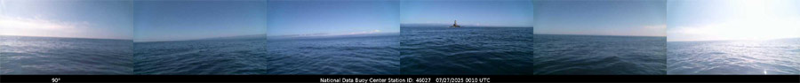
NDBC - Station 46027 - ST GEORGES - 8 NM NW of Crescent City, CA Observations
This feed shows recent marine weather observations from Station 46027.
Station 46027 - ST GEORGES - 8 NM NW of Crescent City, CA
2 Jun 2026 at 9:05pm
June 2, 2026 7:40 pm PDT
Location: 41.84N 124.382W
Wind Direction: S (190°)
Wind Speed: 5.8 knots
Wind Gust: 7.8 knots
Average Period: 6.1 sec
Mean Wave Direction: SW (232°)
Atmospheric Pressure: 30.11 in (1019.7 mb)
Air Temperature: 52.0°F (11.1°C)
Dew Point: 51.3°F (10.7°C)
See the Cape Blanco Lighthouse / Historical Society Weather Station
Oregon Coast Highway, Coast Range Passes Traffic, Road Conditions - | - Portland, Oregon Highway Traffic, Road Conditions - Traffic Cams: I-5 - I-205 - I-405 - Hwy 217 - I-84 - | - List of Oregon Coast Webcams - Weather Cams
SOUTH OREGON COAST RANGE ROAD ALERTS DOUGLAS COUNTY - if empty then no alerts

BROOKINGS WEB-WEATHER CAMS, RADAR
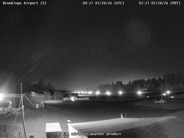
Brookings Airport Live Sky Cam
_pid4918.jpg?rand=1716918878327)
Brookings, Oregon Chetco River Bar Cam
North California (Close to Brookings) Buoy Cam
More Brookings Webcams at Oregon Coast Webcams and at Oregon Coast Road Conditions

Live South Coast Radar
Brookings Oregon Coast Lodging, Hotels, Motels, Restaurants, Inns, Vacation Rentals
BUOY REPORTS - including passing ship reports
![]()
NDBC - Station Observations near 41.84N 124.38W
This feed shows recent marine weather observations from NDBC and its partners within 100 nautical miles of 41.84N 124.38W.
Station 46027 - ST GEORGES - 8 NM NW OF CRESCENT CITY, CA
2 Jun 2026 at 9:09pm
June 2, 2026 6:40 pm PST
Location: 41.84N 124.382W or 0 nautical miles W of search location of 41.84N 124.38W.
Wind Direction: S (190°)
Wind Speed: 6 knots
Wind Gust: 8 knots
Average Period: 6.1 sec
Mean Wave Direction: SW (232°)
Atmospheric Pressure: 30.11 in (1019.7 mb)
Air Temperature: 52°F (11.1°C)
Dew Point: 51°F (10.7°C)
Station CECC1 - 9419750 - CRESCENT CITY, CA
2 Jun 2026 at 9:09pm
June 2, 2026 6:30 pm PST
Location: 41.746N 124.184W or 10 nautical miles ESE of search location of 41.84N 124.38W.
Wind Direction: SSW (200°)
Wind Speed: 4 knots
Wind Gust: 4 knots
Atmospheric Pressure: 30.14 in (1020.5 mb)
Air Temperature: 52°F (10.9°C)
Water Temperature: 55°F (12.6°C)
SHIP
2 Jun 2026 at 9:09pm
June 3, 2026 03:00 UTC
Location: 42.5N 124.8W or 44 nautical miles NNW of search location of 41.84N 124.38W.
Wind Direction: N (360°)
Wind Speed: 7 knots
Atmospheric Pressure: 30.11 in (1019.6 mb)
Air Temperature: 54°F (12.3°C)
Dew Point: 54°F (12.3°C)
Water Temperature: 50°F (9.8°C)
Station TDPC1 - TRINIDAD PIER TRINIDAD, CA
2 Jun 2026 at 9:09pm
June 2, 2026 6:30 pm PST
Location: 41.055N 124.147W or 48 nautical miles SSE of search location of 41.84N 124.38W.
Water Temperature: 50°F (10.0°C)
Station PORO3 - 9431647 - PORT ORFORD, OR
2 Jun 2026 at 9:09pm
June 2, 2026 6:30 pm PST
Location: 42.739N 124.498W or 54 nautical miles N of search location of 41.84N 124.38W.
Wind Direction: SSW (200°)
Wind Speed: 1 knots
Wind Gust: 3 knots
Atmospheric Pressure: 30.10 in (1019.3 mb)
Air Temperature: 54°F (12.0°C)
Water Temperature: 49°F (9.2°C)
Station 46244 - HUMBOLDT BAY, NORTH SPIT, CA (168)
2 Jun 2026 at 9:08pm
June 2, 2026 6:26 pm PST
Location: 40.896N 124.358W or 57 nautical miles S of search location of 41.84N 124.38W.
Significant Wave Height: 4 ft
Dominant Wave Period: 17 sec
Average Period: 6.6 sec
Mean Wave Direction: SW (233°)
Water Temperature: 53°F (11.7°C)
Station 46015 - PORT ORFORD - 15 NM WEST OF PORT ORFORD, OR
2 Jun 2026 at 9:08pm
June 2, 2026 6:40 pm PST
Location: 42.754N 124.839W or 59 nautical miles NNW of search location of 41.84N 124.38W.
Wind Direction: W (280°)
Wind Speed: 4 knots
Wind Gust: 4 knots
Average Period: 6.0 sec
Mean Wave Direction: S (187°)
Atmospheric Pressure: 30.11 in (1019.8 mb)
Air Temperature: 53°F (11.9°C)
Water Temperature: 52°F (11.0°C)
Station HBXC1 - HUMBOLDT, CA
2 Jun 2026 at 9:08pm
June 2, 2026 6:00 pm PST
Location: 40.777N 124.197W or 64 nautical miles S of search location of 41.84N 124.38W.
Water Temperature: 53°F (11.5°C)
Station HBYC1 - 9418767 - NORTH SPIT, CA
2 Jun 2026 at 9:08pm
June 2, 2026 6:36 pm PST
Location: 40.767N 124.217W or 65 nautical miles S of search location of 41.84N 124.38W.
Atmospheric Pressure: 30.14 in (1020.7 mb)
Water Temperature: 52°F (11.0°C)
Station NJLC1 - 9418768 - NORTH JETTY LANDING, CA
2 Jun 2026 at 9:08pm
June 2, 2026 6:30 pm PST
Location: 40.769N 124.239W or 65 nautical miles S of search location of 41.84N 124.38W.
Wind Direction: NE (40°)
Wind Speed: 5 knots
Wind Gust: 6 knots
Air Temperature: 52°F (10.9°C)
Station 46022 - EEL RIVER - 17NM WSW OF EUREKA, CA
2 Jun 2026 at 9:08pm
June 2, 2026 6:40 pm PST
Location: 40.716N 124.54W or 68 nautical miles S of search location of 41.84N 124.38W.
Wind Direction: ENE (70°)
Wind Speed: 6 knots
Wind Gust: 8 knots
Average Period: 6.4 sec
Mean Wave Direction: SSW (205°)
Atmospheric Pressure: 30.13 in (1020.2 mb)
Air Temperature: 52°F (10.9°C)
Water Temperature: 52°F (11.3°C)
Station SNTO3 - TOM'S CREEK, SOUTH SLOUGH RESERVE, OR
2 Jun 2026 at 9:08pm
June 2, 2026 6:30 pm PST
Location: 43.279N 124.318W or 86 nautical miles N of search location of 41.84N 124.38W.
Wind Direction: SSW (210°)
Wind Speed: 3 knots
Atmospheric Pressure: 30.12 in (1020.0 mb)
Air Temperature: 58°F (14.7°C)
Dew Point: 54°F (12.4°C)
Station CHAO3 - 9432780 - CHARLESTON, OR
2 Jun 2026 at 9:08pm
June 2, 2026 6:36 pm PST
Location: 43.351N 124.337W or 91 nautical miles N of search location of 41.84N 124.38W.
Wind Direction: WSW (250°)
Wind Speed: 3 knots
Wind Gust: 5 knots
Atmospheric Pressure: 30.09 in (1019.0 mb)
Latest Weather Articles from Brookings
Free Fishing Weekend All Over Oregon, Coastline
1 Jun 2026 at 10:05pm
Oregon's Free Fishing Weekend returns June 6 - 7, 2026. Brookings events, Gold Beach events, Port Orford events, Coos Bay events, Bandon events, Florence events, Yachats events, Newport events, Lincoln City events, Rockaway Beach events, Manzanita events, Cannon Beach events, Seaside events, Astoria events
State Parks Day Means One Big Freebie for Oregonians - including the coastline
30 May 2026 at 7:01am
June 6 brings free parking to all Oregon state parks for residents. Brookings events, Gold Beach events, Port Orford events, Coos Bay events, Bandon events, Florence events, Yachats events, Newport events, Lincoln City events, Rockaway Beach events, Manzanita events, Cannon Beach events, Seaside events, Astoria events
Shop at the Dock and Discover Oregon Seafood Return to the Coast for Summer
27 May 2026 at 9:15pm
Back to Newport, Garibaldi events, Port Orford events, Winchester Bay events, Brookings events, Newport events, Pacific City events
Oregon Coast Highway 101 Road Conditions, Traffic - Coast Range Passes
22 May 2026 at 9:34pm
Check out all traffic between Astoria, Seaside, Cannon Beach, Pacific City, Newport, Florence, Coos Bay, Bandon, Brookings
Summer-like Week for Oregon, Portland, Coastline - Then Memorial Day Turns
20 May 2026 at 11:34pm
Even a chance of heat risk, but possibly lots of rain on Monday. Weather, Salem, Burns, Medford, Bend, Eugene, Salem, Corvallis, Ontario, The Dalles
4.1 Quake Rattles Off South Oregon Coast Wednesday, A Few Days After 1.6 Quake
16 May 2026 at 8:00am
Slightly larger than the usual shakers, it created no alerts. Sciences, geology
Ontario Eastern Oregon Weather - Forecasts, Sky Cams, Alerts, Current Conditions
Weather forecasts, sky cams, alerts and current conditions for Ontario in eastern Oregon
Super Moon, Blue Moon, Micro Moon and Meteor Shower - All Above Oregon / Wash...
Why we'll be getting extreme large and minus tides, plus meteors and more. Astronomy, weather. Brookings events, Gold Beach events, Port Orford events, Coos Bay events, Bandon events, Florence events, Yachats events, Newport events, Lincoln City events, Rockaway Beach events, Manzanita events, Cannon Beach events, Seaside events, Astoria events
Brookings Oregon Coast Updates
Free Fishing Weekend All Over Oregon, Coastline
1 Jun 2026 at 10:05pm
Oregon's Free Fishing Weekend returns June 6 - 7, 2026. Brookings events, Gold Beach events, Port Orford events, Coos Bay events, Bandon events, Fl...
State Parks Day Means One Big Freebie for Oregonians - including the coastline
30 May 2026 at 7:01am
June 6 brings free parking to all Oregon state parks for residents. Brookings events, Gold Beach events, Port Orford events, Coos Bay events, Bando...
Shop at the Dock and Discover Oregon Seafood Return to the Coast for Summer
27 May 2026 at 9:15pm
Back to Newport, Garibaldi events, Port Orford events, Winchester Bay events, Brookings events, Newport events, Pacific City events
Oregon Coast Highway 101 Road Conditions, Traffic - Coast Range Passes
22 May 2026 at 9:34pm
Check out all traffic between Astoria, Seaside, Cannon Beach, Pacific City, Newport, Florence, Coos Bay, Bandon, Brookings
Astoria / Warrenton Weather
Seaside Weather
Cannon Beach
Manzanita
Nehalem Bay / Wheeler
Rockaway
Oceanside/Tillamook
Pacific City
Lincoln City
Depoe Bay Weather
Newport
Yachats
Florence
Reedsport - Winchester Bay Weather
Coos Bay - North Bend - Charleston
Bandon Weather
Port Orford Weather
Gold Beach Weather
Brookings Weather
Oregon Inland Weather
-- Salem Oregon Weather
-- Portland / Beaverton Oregon Weather
-- Eugene, Oregon Weather
-- Bend, Oregon Weather
-- Medford Oregon Weather
-- Government Camp / Mt Hood Weather
-- West Columbia River Gorge / Cascade Locks, Oregon Weather
How Cape Blanco is a Dividing Line in South Oregon Coast Weather It has an impact but not in ways you'd expect
Oregon's South Coast Towns - and Beaches in Between - Attractions and Brookings, Gold Beach, Port Orford, Bandon, Coos Bay, Charleston, Reedsport, Florence
Oregon Coast Shipwrecks: List of Those You Can See - and Cannot - From Astoria down to Brookings, deep history and details of shipwrecks


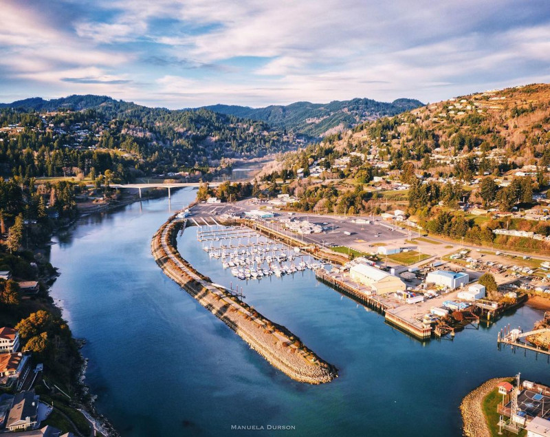
Photo Manuela Durson - Manuela Durson Fine Arts
Search
over 8,500 Pages for Oregon coast subjects, articles or lodging...
Back to Oregon Coast
Contact Advertise on BeachConnection.net
All Content, unless otherwise attributed, copyright BeachConnection.net Unauthorized use or publication is not permitted
Follow us on


South Coast Hotels
Oregon
Coast Hotels Astoria/Warrenton Hotels
Seaside
Cannon
Beach Lodging
Nehalem Bay Lodgings
Manzanita Hotels, Lodging
Rockaway Beach Hotels
Three Capes Lodging
Pacific City Hotels, Lodging
Lincoln
City Lodging
Depoe
Bay Lodging
Newport Lodging
Waldport Lodging
Yachats
Lodging
Oregon
Coast Vacation Rentals
Oregon
Coast Lodging Specials
Oregon Coast Luxury Hotels
Oregon Coast Pet Friendly Hotels/Rentals
Oregon
Coast Bed and Breakfasts / B&Bs
Cannon Beach Vacation Rentals
Pacific City Vacation Rentals
Newport, Depoe Bay Vacation Rentals
Oregon Coast Restaurant, Dining
Guide
Seaside
Cannon
Beach Dining
Manzanita,
Rockaway, Wheeler Dining
Pacific
City, Oceanside, Netarts, Tierra Del Mar Restaurants
Tillamook
Bay Restaurants, Dining
Lincoln
City Dining, Restaurants
Depoe
Bay Restaurants, Dining
Newport Restaurants, Dining
Waldport,
Yachats Restaurants, Dining
Florence Restaurants, Dining
Restaurant
Reviews
Coast
Events Calendar
Astoria
Seaside,
Cannon Beach Calendar
Manzanita,
Rockaway Events
Tillamook,
Pacific City Calendar
Lincoln
City Events Calendar
Newport,
Depoe Bay Events Calendar
Yachats Events Calendar
Oregon Coast Weather
Astoria, Warrenton Weather
Seaside Weather
Cannon Beach
Manzanita
Nehalem Bay / Wheeler
Rockaway
Oceanside/Tillamook
Pacific City
Lincoln City
Depoe Bay Weather
Newport
Yachats
Florence
Reedsport - Winchester Bay Weather
Coos Bay - North Bend - Charleston
Bandon Weather
Port Orford Weather
Gold Beach Weather
Brookings Weather
Search for Oregon Coast Subjects, Articles
Explore Every Beach Spot

Astoria
Where the Columbia meets the Pacific, Land of Lewis & Clark and loads of atmosphere & history

Seaside
The Promenade, Tillamook Head, family fun & broad, sandy beaches

Cannon Beach
A mysterious lighthouse, upscale yet earthy, a huge monolith, fine eateries & an art mecca

Nehalem Bay - Manzanita, Rockaway, Wheeler
Manzanita's beaches, Nehalem and Wheeler's quirky beauty; laid back Rockaway

Tillamook Bay
Garibaldi, Barview, Bay City, Tillamook & an oceanfront ghost town

Three Cape Loop - Oceanside, Netarts, Pacific City
The hidden secret of the coast: Cape Meares, a lighthouse, Oceanside, Netarts and Pacific City

Lincoln City & the Corridor of Mystery
Miles & miles of unbroken beaches, Cascade Head, Neskowin and manmade attractions

Depoe Bay
A spouting horn downtown, freaky hidden cliffs and whales, whales, whales

Newport
Two lighthouses, timeless Nye Beach, bustling bayfront, regal bridge

Waldport, Seal Rock
Sands and dunes, craggy Seal Rock, semi-secret beaches

Yachats
Constantly dramatic wave action, a mix of the rugged & upscale

Upper Lane County
25 miles of deserted beaches & oodles of wonders

Florence
A lighthouse, ancient bayfront and miles and miles of fluffy dunes
South Oregon Coast Travel
News Headlines from All Over Oregon Need to scan Oregon headlines? Constantly updated news from all over Oregon: a comprehensive, up-to-the-minute display of news headlines from a variety of media
Oregon Coast Oceanfront Lodging, Hotels, Rentals