


MANZANITA WEATHER | 7-DAY FORECAST | WEATHER CAMS | TIDES | ALERTS | OREGON COAST - LIVE RADAR
Updated Constantly: Manzanita Oregon Coast Weather | Manzanita Web Cams | Tides | Alerts - Current conditions, forecasts, tides, live radar, weather cams | North Coast Range travel, storm alerts | Buoy reports and reports from passing ships
MANZANITA, OREGON 7-DAY FORECAST
Small Craft Advisory issued May 2 at 1:35AM PDT until May 2 at 2:00AM PDT by ...
2 May 2026 at 2:35am
Northerly winds and gusts have fallen below thresholds hazardous
to small craft.

Manzanita Tide Tables - | - General Oregon Weather - | - Washington Coast Weather
Oregon Coast Highway, Coast Range Passes Traffic, Road Conditions - | - Portland, Oregon Highway Traffic, Road Conditions - Traffic Cams: I-5 - I-205 - I-405 - Hwy 217 - I-84 - | - List of Oregon Coast Webcams - Weather Cams
NORTH OREGON COAST RANGE - if empty then no alerts

MANZANITA LIVE WEATHER CAMS - LIVE RADAR
Manzanita Web Cam (through Ocean Inn) (click here to explore)
CLICK HERE FOR
Buoy Cam - West of Tillamook

NORTH COAST LIVE RADAR
Manzanita / Wheeler / Nehalem Bay, Oregon Coast Lodging, Hotels, Motels, Restaurants, Inns, Vacation Rentals
Nehalem Bay, Nehalem, Wheeler, Rockaway Beach and Manzanita, Oregon Lodging, ...
Find places to stay in Nehalem, Wheeler, Manzanita, Rockaway Beach; places to eat, dine in Nehalem, Wheeler, Manzanita, Rockaway Beach
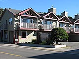
Ocean Inn, Manzanita
Ten beautifully appointed units on the beach
Nehalem River Inn
Historic, boutique hotel in lush forest
Riverfront Views in Nehalem
Hotel right on the north coast river
Tradewinds Motel, Rockaway
Oceanfront, rooms for couples to large groups
MacGregor's A Whiskey Bar, Manzanita
Upscale, intimate cocktail lounge w/ stellar gourmet food
Sheltered Nook at Tillamook Bay
Vacation rentals at Bay City, tiny homes, very eco-friendly
Rockaway Retreat - Rockaway Beach Vacation Rental
Rockaway Beach vacation rental, Rockaway Beach lodging with BBQ, Jucuzzi, near the ocean
Beachcombers NW
Oregon and Washington Coast Vacation Rentals
Oregon Coast Lodging Fantastic Views on Video
From the balconies and patios of oceanfront hotels, motels and vacation rentals, to the sights you'll see by simply walking or driving a few minutes away. Lodging Deals
Dining, Restaurants, Menus in Rockaway, Manzanita, Nehalem, Wheeler, Oregon.
Guide to Manzanita, Oregon Hotels
North Oregon coast; pet friendly vacation rentals, kid friendly, oceanfront, beachfront, views
BUOY REPORTS Near Manzanita
![]()
NDBC - Station 46089 - TILLAMOOK, OR - 85 NM WNW of Tillamook, OR Observations
This feed shows recent marine weather observations from Station 46089.
Station 46089 - TILLAMOOK, OR - 85 NM WNW of Tillamook, OR
8 May 2026 at 7:10pm
May 8, 2026 5:50 pm PDT
Location: 45.928N 125.815W
Wind Direction: SSW (200°)
Wind Speed: 7.8 knots
Wind Gust: 9.7 knots
Significant Wave Height: 3.9 ft
Dominant Wave Period: 14 sec
Average Period: 5.2 sec
Mean Wave Direction: SW (232°)
Atmospheric Pressure: 30.16 in (1021.4 mb)
Water Temperature: 55.9°F (13.3°C)
![]()
NDBC - Station Observations near 45.93N 125.82W
This feed shows recent marine weather observations from NDBC and its partners within 100 nautical miles of 45.93N 125.82W.
Station 46089 - TILLAMOOK, OR - 85 NM WNW OF TILLAMOOK, OR
8 May 2026 at 7:20pm
May 8, 2026 4:50 pm PST
Location: 45.928N 125.815W or 0 nautical miles ESE of search location of 45.93N 125.82W.
Wind Direction: SSW (200°)
Wind Speed: 8 knots
Wind Gust: 10 knots
Significant Wave Height: 4 ft
Dominant Wave Period: 14 sec
Average Period: 5.2 sec
Mean Wave Direction: SW (232°)
Atmospheric Pressure: 30.16 in (1021.4 mb)
Water Temperature: 56°F (13.3°C)
Station 46248 - ASTORIA CANYON, OR (179)
8 May 2026 at 7:20pm
May 8, 2026 4:56 pm PST
Location: 46.133N 124.64W or 51 nautical miles ENE of search location of 45.93N 125.82W.
Significant Wave Height: 4 ft
Dominant Wave Period: 14 sec
Average Period: 5.4 sec
Mean Wave Direction: WSW (241°)
Water Temperature: 55°F (12.9°C)
SHIP
8 May 2026 at 7:20pm
May 9, 2026 01:00 UTC
Location: 46.8N 126.1W or 53 nautical miles NNW of search location of 45.93N 125.82W.
Atmospheric Pressure: 30.16 in (1021.3 mb)
Pressure Tendency: +0.04 in (+1.2 mb)
Air Temperature: 56°F (13.1°C)
Dew Point: 53°F (11.7°C)
Station 46029 - COLUMBIA RIVER BAR - 20NM WEST OF COLUMBIA RIVER MOUTH
8 May 2026 at 7:20pm
May 8, 2026 5:00 pm PST
Location: 46.148N 124.508W or 56 nautical miles ENE of search location of 45.93N 125.82W.
Wind Direction: S (190°)
Wind Speed: 12 knots
Wind Gust: 14 knots
Atmospheric Pressure: 30.19 in (1022.3 mb)
Pressure Tendency: -0.01 in (-0.4 mb)
Air Temperature: 54°F (12.1°C)
Dew Point: 52°F (11.1°C)
Water Temperature: 55°F (12.8°C)
Station 46243 - CLATSOP SPIT, OR (162)
8 May 2026 at 7:20pm
May 8, 2026 5:00 pm PST
Location: 46.215N 124.129W or 72 nautical miles ENE of search location of 45.93N 125.82W.
Significant Wave Height: 3 ft
Dominant Wave Period: 10 sec
Average Period: 5.4 sec
Mean Wave Direction: W (275°)
Air Temperature: 55°F (12.7°C)
Water Temperature: 56°F (13.4°C)
Station 46278 - TILLAMOOK BAY SOUTH JETTY, OR (270)
8 May 2026 at 7:20pm
May 8, 2026 5:00 pm PST
Location: 45.559N 123.991W or 80 nautical miles ESE of search location of 45.93N 125.82W.
Significant Wave Height: 3 ft
Dominant Wave Period: 4 sec
Average Period: 5.4 sec
Mean Wave Direction: SW (235°)
Air Temperature: 56°F (13.1°C)
Water Temperature: 56°F (13.6°C)
Station 46211 - GRAYS HARBOR, WA (036)
8 May 2026 at 7:20pm
May 8, 2026 4:56 pm PST
Location: 46.857N 124.243W or 86 nautical miles NE of search location of 45.93N 125.82W.
Significant Wave Height: 3 ft
Dominant Wave Period: 4 sec
Average Period: 4.8 sec
Mean Wave Direction: SW (223°)
Water Temperature: 55°F (13.0°C)
Station ASTO3 - 9439040 - ASTORIA, OR
8 May 2026 at 7:20pm
May 8, 2026 4:48 pm PST
Location: 46.207N 123.768W or 87 nautical miles ENE of search location of 45.93N 125.82W.
Wind Direction: WNW (300°)
Wind Speed: 9 knots
Wind Gust: 11 knots
Station TOKW1 - 9440910 - TOKE POINT, WA
8 May 2026 at 7:20pm
May 8, 2026 4:48 pm PST
Location: 46.707N 123.967W or 90 nautical miles ENE of search location of 45.93N 125.82W.
Wind Direction: SW (230°)
Wind Speed: 6 knots
Wind Gust: 9 knots
Atmospheric Pressure: 30.21 in (1023.0 mb)
Station WPTW1 - 9441102 - WESTPORT, WA
8 May 2026 at 7:20pm
May 8, 2026 4:36 pm PST
Location: 46.904N 124.105W or 92 nautical miles NE of search location of 45.93N 125.82W.
Wind Direction: SSW (200°)
Wind Speed: 9 knots
Wind Gust: 13 knots
Atmospheric Pressure: 30.20 in (1022.7 mb)
Air Temperature: 53°F (11.7°C)
Water Temperature: 56°F (13.2°C)
Station 46050 - STONEWALL BANK - 20NM WEST OF NEWPORT, OR
8 May 2026 at 7:20pm
May 8, 2026 4:50 pm PST
Location: 44.679N 124.535W or 93 nautical miles SE of search location of 45.93N 125.82W.
Wind Direction: WSW (240°)
Wind Speed: 8 knots
Wind Gust: 8 knots
Significant Wave Height: 4 ft
Dominant Wave Period: 15 sec
Average Period: 6.1 sec
Mean Wave Direction: W (260°)
Atmospheric Pressure: 30.20 in (1022.8 mb)
Station 46041 - CAPE ELIZABETH - 45NM NW OF ABERDEEN, WA
8 May 2026 at 7:20pm
May 8, 2026 4:50 pm PST
Location: 47.352N 124.739W or 96 nautical miles NNE of search location of 45.93N 125.82W.
Wind Direction: SSE (150°)
Wind Speed: 14 knots
Wind Gust: 16 knots
Significant Wave Height: 3 ft
Dominant Wave Period: 14 sec
Average Period: 4.5 sec
Mean Wave Direction: SW (229°)
Atmospheric Pressure: 30.19 in (1022.5 mb)
Air Temperature: 53°F (11.5°C)
Dew Point: 53°F (11.5°C)
Latest Weather Articles from Manzanita
Drone Ban Along Majority of Oregon Coast: A Deeper Dive and Strong Reactions
A look at rule details, how it affects creators. Weather
Ontario Eastern Oregon Weather - Forecasts, Sky Cams, Alerts, Current Conditions
Weather forecasts, sky cams, alerts and current conditions for Ontario in eastern Oregon
Yet Another Rare Sighting of Snowy Owl on Oregon Coast - Third This Year
Latest in Newport, two others this year. Sciences
Another Major Fireball Above Washington, Oregon - Caught on Video on the Coast
Reported by over 100 people and mapped by NASA satellites. Astronomy, weather
Super Moon, Blue Moon, Micro Moon and Meteor Shower - All Above Oregon / Wash...
Why we'll be getting extreme large and minus tides, plus meteors and more. Astronomy, weather. Brookings events, Gold Beach events, Port Orford events, Coos Bay events, Bandon events, Florence events, Yachats events, Newport events, Lincoln City events, Rockaway Beach events, Manzanita events, Cannon Beach events, Seaside events, Astoria events
This Weekend's Aurora Displayed Some Rarities Mostly to Central Oregon Coast
What could be light pillars, the STEVE effect and a rare red glow. Weather, astronomy. Seattle, Portland, Washington, Bend, Salem
Oregon State Police Asking for Tips on Elk Killing on Coast, at Cannon Beach
There may be a reward in it for helping to find the person responsible. Safety, crime
Two More Whales Wash Up on Washington Coast This Week: One a Rarity
One a Baird's beaked whale the other the 11th gray whale in a month. Marine sciences, Ocean Shores, Moclips
Astoria / Warrenton Weather
Seaside Weather
Cannon Beach
Manzanita
Nehalem Bay / Wheeler
Rockaway
Oceanside/Tillamook
Pacific City
Lincoln City
Depoe Bay Weather
Newport
Yachats
Florence
Reedsport - Winchester Bay Weather
Coos Bay - North Bend - Charleston
Bandon Weather
Port Orford Weather
Gold Beach Weather
Brookings Weather
Washington Coast Weather
South Oregon Coast Travel

Manzanita / Nehalem Bay
Manzanita's beaches, Nehalem and Wheeler's quirky beauty; laidback Rockaway


Oregon Inland Weather
-- Salem Oregon Weather
-- Portland / Beaverton Oregon Weather
-- Eugene / Springfield Weather
-- Bend Central Oregon Weather
-- Medford Oregon Weather
-- Government Camp / Mt Hood Weather
-- West Columbia River Gorge / Cascade Locks, Oregon Weather
-- Corvallis / Albany Oregon Weather


Search
over 7,500 Pages for Oregon coast subjects, articles or lodging...
Back to Oregon Coast
Contact Advertise on BeachConnection.net
All Content, unless otherwise attributed, copyright BeachConnection.net Unauthorized use or publication is not permitted
Follow us on


South Coast Hotels
Oregon
Coast Hotels Astoria/Warrenton Hotels
Seaside
Cannon
Beach Lodging
Nehalem Bay Lodgings
Manzanita Hotels, Lodging
Rockaway Beach Hotels
Three Capes Lodging
Pacific City Hotels, Lodging
Lincoln
City Lodging
Depoe
Bay Lodging
Newport Lodging
Waldport Lodging
Yachats
Lodging
Florence Hotels
Reedsport Hotels
Coos Bay Hotels
Bandon Hotels
Port Orford Hotels
Gold Beach Hotels
Brookings Hotels
Oregon
Coast Vacation Rentals
Oregon
Coast Lodging Specials
Oregon Coast Luxury Hotels
Oregon Coast Pet Friendly Hotels/Rentals
Oregon
Coast Bed and Breakfasts / B&Bs
Cannon Beach Vacation Rentals
Pacific City Vacation Rentals
Newport, Depoe Bay Vacation Rentals
Oregon Coast Restaurant, Dining
Guide
Seaside
Cannon
Beach Dining
Manzanita,
Rockaway, Wheeler Dining
Pacific
City, Oceanside, Netarts, Tierra Del Mar Restaurants
Tillamook
Bay Restaurants, Dining
Lincoln
City Dining, Restaurants
Depoe
Bay Restaurants, Dining
Newport Restaurants, Dining
Waldport,
Yachats Restaurants, Dining
Florence Restaurants, Dining
Restaurant
Reviews
Coast
Events Calendar
Astoria
Seaside,
Cannon Beach Calendar
Manzanita,
Rockaway Events
Tillamook,
Pacific City Calendar
Lincoln
City Events Calendar
Newport,
Depoe Bay Events Calendar
Yachats Events Calendar
Oregon Coast Weather
Astoria, Warrenton Weather
Seaside Weather
Cannon Beach
Manzanita
Nehalem Bay / Wheeler
Rockaway
Oceanside/Tillamook
Pacific City
Lincoln City
Depoe Bay Weather
Newport
Yachats
Florence
Reedsport - Winchester Bay Weather
Coos Bay - North Bend - Charleston
Bandon Weather
Port Orford Weather
Gold Beach Weather
Brookings Weather
Search for Oregon Coast Subjects, Articles
Explore Every Beach Spot

Astoria
Where the Columbia meets the Pacific, Land of Lewis & Clark and loads of atmosphere & history

Seaside
The Promenade, Tillamook Head, family fun & broad, sandy beaches

Cannon Beach
A mysterious lighthouse, upscale yet earthy, a huge monolith, fine eateries & an art mecca
Nehalem Bay - Manzanita, Rockaway, Wheeler
Manzanita's beaches, Nehalem and Wheeler's quirky beauty; laid back Rockaway

Tillamook Bay
Garibaldi, Barview, Bay City, Tillamook & an oceanfront ghost town

Three Cape Loop - Oceanside, Netarts, Pacific City
The hidden secret of the coast: Cape Meares, a lighthouse, Oceanside, Netarts and Pacific City

Lincoln City & the Corridor of Mystery
Miles & miles of unbroken beaches, Cascade Head, Neskowin and manmade attractions

Depoe Bay
A spouting horn downtown, freaky hidden cliffs and whales, whales, whales

Newport
Two lighthouses, timeless Nye Beach, bustling bayfront, regal bridge

Waldport, Seal Rock
Sands and dunes, craggy Seal Rock, semi-secret beaches

Yachats
Constantly dramatic wave action, a mix of the rugged & upscale

Upper Lane County
25 miles of deserted beaches & oodles of wonders

Florence
A lighthouse, ancient bayfront and miles and miles of fluffy dunes
South Oregon Coast Travel
News Headlines from All Over Oregon Need to scan Oregon headlines? Constantly updated news from all over Oregon: a comprehensive, up-to-the-minute display of news headlines from a variety of media
Oregon Coast Oceanfront Lodging, Hotels, Rentals