


NEWPORT OREGON 7-DAY FORECAST | WAVE FORECAST | WEATHER | WEATHER CAMS | TIDES | ALERTS
NEWPORT 7-DAY FORECAST + WAVE HEIGHT

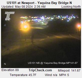
Oregon Coast Highway, Coast Range Passes Traffic, Road Conditions - | - Portland, Oregon Highway Traffic, Road Conditions - Traffic Cams: I-5 - I-205 - I-405 - Hwy 217 - I-84 - | - List of Oregon Coast Webcams - Weather Cams
NEWPORT ALERTS - STORM, AIR, HEAT, WAVES
(if empty then no alerts)
Watches, warnings, and advisories issued since Wed, Jan 29, 2025 9:07:21 AM -...
TEST Tsunami Warning issued April 30 at 9:30AM PDT until April 30 at 10:30AM ...
30 Apr 2026 at 10:30am
PZZ530-531-CAZ043-354-362-366-367-552-087-549-550-349-350-
340>342-346-529-530-006-156-505-506-508>510-109-104-103-101-
ORZ021-022-103-101-102-WAZ001-201-310-311-324>326-330>333-
BCZ098-099-096-097-AKZ328>332-323-324-326-327-318>322-325-
317-731-735-721>723-725-728-729-771>773-781-785-787-795-791-
301730-
/T.NEW.PAAQ.TS.W.9008.260430T1630Z-260430T1730Z/
Alaska, British Columbia, Washington, Oregon and California
coastal areas
...THIS_MESSAGE_IS_FOR_TEST_PURPOSES_ONLY...
...THIS IS A TEST TO DETERMINE TRANSMISSION TIMES INVOLVED IN THE
DISSEMINATION OF TSUNAMI INFORMATION...
RESPONSES ARE REQUIRED FROM
---------------------------
* All Coastal Weather Forecast Offices in Alaska, Washington,
Oregon and California
* USAF 11th Rescue Coordination Center at Elmendorf AFB
* California, Oregon, Washington and Alaska State Warning Points
* Emergency Management British Columbia
* The Pacific Storm Prediction Centre in British Columbia
* Joint Typhoon Warning Center in Hawaii
* U.S. Coast Guard 11th, 13th, 17th District Offices
* U.S. Coast Guard Kodiak COMMSTA and CAMSPAC Point Reyes, CA
* Canadian Coast Guard MCTS COMOX and/or Victoria
* FAA Regional Operations Center in Seattle
* All Pacific Coast Tsunamiready Community Warning Points.
RESPONSES SHOULD INCLUDE
------------------------
* Time-of-receipt
* Agency name
* Email address
* Phone number
Weather Service Offices should respond in accordance with local
directives. All others should reply by one of the available methods
below.
SEND RESPONSE BY
----------------
* Email address - ntwc@noaa.gov
* AFTN address - PAAQYQYX
* AWIPS - TMA
* Fax - 907-745-6071
...THIS_MESSAGE_IS_FOR_TEST_PURPOSES_ONLY...
...THIS IS A TEST TO DETERMINE TRANSMISSION TIMES INVOLVED IN THE
DISSEMINATION OF TSUNAMI INFORMATION...
Watches, warnings, and advisories issued since Wed, Jan 29, 2025 9:07:21 AM -...
Small Craft Advisory issued May 2 at 1:35AM PDT until May 2 at 2:00AM PDT by ...
2 May 2026 at 2:35am
Northerly winds and gusts have fallen below thresholds hazardous
to small craft.
Small Craft Advisory issued May 1 at 1:57PM PDT until May 2 at 2:00AM PDT by ...
1 May 2026 at 2:57pm
* WHAT...Seas around 6 ft at 12 seconds and northwest winds 10
to 20 kt with gusts up to 25 kt expected.
* WHERE...Coastal waters from Cape Falcon to Cape Foulweather OR
out 10 NM, Coastal waters from Cape Foulweather to Florence OR
out 10 NM and Waters from Cape Shoalwater WA to Cape Falcon OR
from 10 to 60 NM.
* WHEN...Until 2 AM PDT Saturday.
* IMPACTS...Conditions will be hazardous to small craft.
Small Craft Advisory issued May 1 at 7:59AM PDT until May 2 at 2:00AM PDT by ...
1 May 2026 at 8:59am
* WHAT...Seas 6 to 8 ft at 12 seconds and northwest winds 15 to
20 kt with gusts up to 25 kt expected.
* WHERE...Coastal waters from Cape Falcon to Cape Foulweather OR
out 10 NM, Coastal waters from Cape Foulweather to Florence OR
out 10 NM and Waters from Cape Shoalwater WA to Cape Falcon OR
from 10 to 60 NM.
* WHEN...From 2 PM this afternoon to 2 AM PDT Saturday.
* IMPACTS...Conditions will be hazardous to small craft.
CENTRAL OREGON COAST RANGE
Current watches, warnings, and advisories for Central Oregon Coast Range (ORZ...

BUOY REPORTS
![]()
NDBC - Station 46281 - Newport PWS South, OR (278) Observations
This feed shows recent marine weather observations from Station 46281.
Station 46281 - Newport PWS South, OR (278)
5 May 2026 at 9:40am
May 5, 2026 8:26 am PDT
Location: 44.559N 124.233W
Significant Wave Height: 5.2 ft
Dominant Wave Period: 12 sec
Average Period: 8.9 sec
Mean Wave Direction: WNW (286°)
Water Temperature: 53.2°F (11.8°C)
![]()
NDBC - Station Observations near 44.38N 124.95W
This feed shows recent marine weather observations from NDBC and its partners within 100 nautical miles of 44.38N 124.95W.
Station 46050 - STONEWALL BANK - 20NM WEST OF NEWPORT, OR
5 May 2026 at 9:45am
May 5, 2026 7:10 am PST
Location: 44.679N 124.535W or 25 nautical miles NE of search location of 44.38N 124.95W.
Wind Direction: SSW (200°)
Wind Speed: 6 knots
Wind Gust: 8 knots
Average Period: 7.7 sec
Mean Wave Direction: WNW (288°)
Atmospheric Pressure: 30.01 in (1016.4 mb)
Station 46097 - OOI NEWPORT SHELF
5 May 2026 at 9:45am
May 5, 2026 5:50 am PST
Location: 44.639N 124.304W or 32 nautical miles ENE of search location of 44.38N 124.95W.
Wind Direction: S (180°)
Wind Speed: 8 knots
Atmospheric Pressure: 29.98 in (1015.3 mb)
Air Temperature: 53°F (11.8°C)
Water Temperature: 54°F (12.4°C)
Station 46281 - NEWPORT PWS SOUTH, OR (278)
5 May 2026 at 9:45am
May 5, 2026 7:26 am PST
Location: 44.559N 124.233W or 33 nautical miles ENE of search location of 44.38N 124.95W.
Significant Wave Height: 5 ft
Dominant Wave Period: 12 sec
Average Period: 8.9 sec
Mean Wave Direction: WNW (286°)
Water Temperature: 53°F (11.8°C)
Station 46283 - YAQUINA CHANNEL SW, OR (280)
5 May 2026 at 9:45am
May 5, 2026 7:26 am PST
Location: 44.567N 124.237W or 33 nautical miles ENE of search location of 44.38N 124.95W.
Significant Wave Height: 5 ft
Dominant Wave Period: 12 sec
Average Period: 8.5 sec
Mean Wave Direction: WNW (292°)
Station 46229 - UMPQUA OFFSHORE, OR (139)
5 May 2026 at 9:45am
May 5, 2026 7:00 am PST
Location: 43.772N 124.549W or 40 nautical miles SSE of search location of 44.38N 124.95W.
Significant Wave Height: 6 ft
Dominant Wave Period: 13 sec
Average Period: 8.9 sec
Mean Wave Direction: WNW (289°)
Air Temperature: 54°F (12.1°C)
Water Temperature: 54°F (12.3°C)
Station NWPO3 - NEWPORT, OR
5 May 2026 at 9:45am
May 5, 2026 7:00 am PST
Location: 44.613N 124.067W or 40 nautical miles ENE of search location of 44.38N 124.95W.
Wind Direction: SSW (200°)
Wind Speed: 3 knots
Wind Gust: 4 knots
Air Temperature: 53°F (11.6°C)
Station SBEO3 - 9435380 - SOUTH BEACH, OR
5 May 2026 at 9:45am
May 5, 2026 7:00 am PST
Location: 44.625N 124.045W or 41 nautical miles ENE of search location of 44.38N 124.95W.
Atmospheric Pressure: 30.01 in (1016.4 mb)
Pressure Tendency: +0.03 in (+0.9 mb)
Station CHAO3 - 9432780 - CHARLESTON, OR
5 May 2026 at 9:45am
May 5, 2026 6:36 am PST
Location: 43.351N 124.337W or 67 nautical miles SSE of search location of 44.38N 124.95W.
Wind Speed: 0 knots
Wind Gust: 2 knots
Atmospheric Pressure: 30.00 in (1015.9 mb)
Station SNTO3 - TOM'S CREEK, SOUTH SLOUGH RESERVE, OR
5 May 2026 at 9:45am
May 5, 2026 6:30 am PST
Location: 43.279N 124.318W or 72 nautical miles SSE of search location of 44.38N 124.95W.
Wind Speed: 0 knots
Atmospheric Pressure: 30.03 in (1017.0 mb)
Air Temperature: 53°F (11.9°C)
Dew Point: 52°F (11.0°C)
Station 46278 - TILLAMOOK BAY SOUTH JETTY, OR (270)
5 May 2026 at 9:45am
May 5, 2026 7:00 am PST
Location: 45.559N 123.991W or 82 nautical miles NNE of search location of 44.38N 124.95W.
Significant Wave Height: 5 ft
Dominant Wave Period: 12 sec
Average Period: 7.5 sec
Mean Wave Direction: W (278°)
Air Temperature: 54°F (12.4°C)
Water Temperature: 55°F (12.9°C)
Station 46015 - PORT ORFORD - 15 NM WEST OF PORT ORFORD, OR
5 May 2026 at 9:45am
May 5, 2026 7:20 am PST
Location: 42.754N 124.839W or 98 nautical miles S of search location of 44.38N 124.95W.
Wind Speed: 0 knots
Wind Gust: 2 knots
Significant Wave Height: 5 ft
Dominant Wave Period: 10 sec
Average Period: 8.1 sec
Mean Wave Direction: WNW (302°)
Atmospheric Pressure: 30.02 in (1016.7 mb)
Air Temperature: 53°F (11.8°C)
Water Temperature: 54°F (12.1°C)
Station 46089 - TILLAMOOK, OR - 85 NM WNW OF TILLAMOOK, OR
5 May 2026 at 9:45am
May 5, 2026 7:10 am PST
Location: 45.928N 125.815W or 100 nautical miles NNW of search location of 44.38N 124.95W.
Wind Direction: SSE (160°)
Wind Speed: 8 knots
Wind Gust: 14 knots
Average Period: 7.9 sec
Mean Wave Direction: W (275°)
Atmospheric Pressure: 29.98 in (1015.2 mb)
Water Temperature: 56°F (13.1°C)
Newport, Oregon Lodging, Hotels, Motels, Restaurants, Inns, Vacation Rentals
newport, Oregon, Lodging, Hotels, Motels, Restaurants, Inns, Vacation Rentals
Find places to stay in Newport, Oregon; places to eat, dine in Newport
Agate Beach Motel
Charmer nestled in the cove of Agate Beach
Inn at Nye Beach, Newport Hotel
The beauty on a bluff on the central Oregon coast. Upscale and pet friendly, wine, heaps of charm. Newport lodging.
Moolack Shores, Newport
Historic charmer overlooking stunning Moolack Beach
Nye Beach Condos and Cottages
A variety of sleek condos and homey even historic cottage vacation rentals
Newport Inn 'n Suites
Pet friendly, inexpensive fun on 101
The Waves Hotel, Newport
Newport's Nye Beach. Full ocean views. Pet friendly. 541-265-4661
Beachcombers NW Rentals in Newport
Oregon and Washington Coast Vacation Rentals
Central Oregon Coast Lodging Delights, Newport Rentals
Lodgings near a lighthouse, on the bay, oceanfront
Dining, Restaurants, Menus in Newport, Oregon
Bed and Breakfast's in Newport
Overlooking the beaches, romantic vibes, more
Newport, Central Coast Weather Alerts, Articles
Drone Ban Along Majority of Oregon Coast: A Deeper Dive and Strong Reactions
A look at rule details, how it affects creators. Weather
Ontario Eastern Oregon Weather - Forecasts, Sky Cams, Alerts, Current Conditions
Weather forecasts, sky cams, alerts and current conditions for Ontario in eastern Oregon
Yet Another Rare Sighting of Snowy Owl on Oregon Coast - Third This Year
Latest in Newport, two others this year. Sciences
Another Major Fireball Above Washington, Oregon - Caught on Video on the Coast
Reported by over 100 people and mapped by NASA satellites. Astronomy, weather
Astoria / Warrenton Weather
Seaside Weather
Cannon Beach
Manzanita
Nehalem Bay / Wheeler
Rockaway
Oceanside/Tillamook
Pacific City
Lincoln City
Depoe Bay Weather
Newport
Yachats
Florence
Reedsport - Winchester Bay Weather
Coos Bay - North Bend - Charleston
Bandon Weather
Port Orford Weather
Gold Beach Weather
Brookings Weather

Newport Virtual Tour - Complete Guide (Every Beach Access)
Yaquina Head, two lighthouses, sandy beaches
Oregon Inland Weather
-- Salem Oregon Weather
-- Portland / Beaverton Oregon Weather
-- Eugene / Springfield Weather
-- Bend Central Oregon Weather
-- Medford Oregon Weather
-- Government Camp / Mt Hood Weather
-- West Columbia River Gorge / Cascade Locks, Oregon Weather
-- Corvallis / Albany Oregon Weather


Search over 7,5000 Pages for Oregon coast subjects, articles or lodging...
Back to Oregon Coast
Contact Advertise on BeachConnection.net
All Content, unless otherwise attributed, copyright BeachConnection.net Unauthorized use or publication is not permitted
Follow us on


South Coast Hotels
Oregon
Coast Hotels Astoria/Warrenton Hotels
Seaside
Cannon
Beach Lodging
Nehalem Bay Lodgings
Manzanita Hotels, Lodging
Rockaway Beach Hotels
Three Capes Lodging
Pacific City Hotels, Lodging
Lincoln
City Lodging
Depoe
Bay Lodging
Newport Lodging
Waldport Lodging
Yachats
Lodging
Florence Hotels
Reedsport Hotels
Coos Bay Hotels
Bandon Hotels
Port Orford Hotels
Gold Beach Hotels
Brookings Hotels
Oregon
Coast Vacation Rentals
Oregon
Coast Lodging Specials
Oregon Coast Luxury Hotels
Oregon Coast Pet Friendly Hotels/Rentals
Oregon
Coast Bed and Breakfasts / B&Bs
Cannon Beach Vacation Rentals
Pacific City Vacation Rentals
Newport, Depoe Bay Vacation Rentals
Oregon Coast Restaurant, Dining
Guide
Seaside
Cannon
Beach Dining
Manzanita,
Rockaway, Wheeler Dining
Pacific
City, Oceanside, Netarts, Tierra Del Mar Restaurants
Tillamook
Bay Restaurants, Dining
Lincoln
City Dining, Restaurants
Depoe
Bay Restaurants, Dining
Newport Restaurants, Dining
Waldport,
Yachats Restaurants, Dining
Florence Restaurants, Dining
Restaurant
Reviews
Coast
Events Calendar
Astoria
Seaside,
Cannon Beach Calendar
Manzanita,
Rockaway Events
Tillamook,
Pacific City Calendar
Lincoln
City Events Calendar
Newport,
Depoe Bay Events Calendar
Yachats Events Calendar
Oregon Coast Weather
Astoria, Warrenton Weather
Seaside Weather
Cannon Beach
Manzanita
Nehalem Bay / Wheeler
Rockaway
Oceanside/Tillamook
Pacific City
Lincoln City
Depoe Bay Weather
Newport
Yachats
Florence
Reedsport - Winchester Bay Weather
Coos Bay - North Bend - Charleston
Bandon Weather
Port Orford Weather
Gold Beach Weather
Brookings Weather
Search for Oregon Coast Subjects, Articles
Explore Every Beach Spot

Astoria
Where the Columbia meets the Pacific, Land of Lewis & Clark and loads of atmosphere & history

Seaside
The Promenade, Tillamook Head, family fun & broad, sandy beaches

Cannon Beach
A mysterious lighthouse, upscale yet earthy, a huge monolith, fine eateries & an art mecca

Nehalem Bay - Manzanita, Rockaway, Wheeler
Manzanita's beaches, Nehalem and Wheeler's quirky beauty; laid back Rockaway

Tillamook Bay
Garibaldi, Barview, Bay City, Tillamook & an oceanfront ghost town

Three Cape Loop - Oceanside, Netarts, Pacific City
The hidden secret of the coast: Cape Meares, a lighthouse, Oceanside, Netarts and Pacific City

Lincoln City & the Corridor of Mystery
Miles & miles of unbroken beaches, Cascade Head, Neskowin and manmade attractions

Depoe Bay
A spouting horn downtown, freaky hidden cliffs and whales, whales, whales
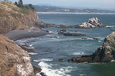
Newport
Two lighthouses, timeless Nye Beach, bustling bayfront, regal bridge

Waldport, Seal Rock
Sands and dunes, craggy Seal Rock, semi-secret beaches

Yachats
Constantly dramatic wave action, a mix of the rugged & upscale

Upper Lane County
25 miles of deserted beaches & oodles of wonders

Florence
A lighthouse, ancient bayfront and miles and miles of fluffy dunes
South Oregon Coast Travel
News Headlines from All Over Oregon Need to scan Oregon headlines? Constantly updated news from all over Oregon: a comprehensive, up-to-the-minute display of news headlines from a variety of media
Oregon Coast Oceanfront Lodging, Hotels, Rentals