 |
Same Oregon Coast Beach, Three Distinct Visions - One Freaky Geology Lesson
Published 02/03/2011
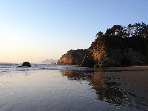
(Cannon Beach, Oregon) – Hug Point, on the north Oregon coast, is one of those wildly distinctive wonders that yields more and more the further you delve into it. It’s like peeling back layers of an onion and finding one startling thing of beauty after another, along with some bizarre lessons in science.
This state park, just south of Cannon Beach, looks at first like just a small cove-like area. But at decently midrange to low tides, you can walk around that first headland to discover a waterfall, a series of funky caves (that often contain freaky, prehistoric-looking bugs), and then a mysterious road carved into the rock.
During the day, as above, you’ll notice an odd zigzag pattern in the first rocky promontory. This weird pattern, according to Seaside geologist Tom Horning, is the result of one of the processes behind the re-eruptions of the fiery time that created Haystack Rock – the famous landmark within Cannon Beach’s borders.
Millions and millions of years ago, this whole area was not just underwater, but under lava flows sometimes as well. These were so enormous and powerful they would plunge into the sea, down through the sea floor, and would then re-erupt in mini eruptions that formed things like Haystack Rock.
This odd pattern in the rock is related.
“The Angora Peak sandstone of the Astoria Formation here (from the Miocene age) has been invaded by Columbia River Basalt lavas, which form dark bands and large dark masses in the golden sands,” Horning said. “Because the sandstone hadn't yet been cemented and become brittle, the invasion of lava pushed the sands around and warped and folded them, locally blowing them up in lava-heated steam explosions near the sea floor.”
Horning further explains that these sandstones were buried several hundred feet beneath an overlying layer of deeper water mudstones at the time of the lava invasions. This allows geologists to trace some really prehistoric landmarks.
“If you put it all together, the sandstone represents the estuary of the Columbia River in Miocene time,” Horning said. “It was during a period of coast regional downwarp, which shifted the shoreline eastward, and allowed the deepwater mud to bury the slightly older estuary deposits.”
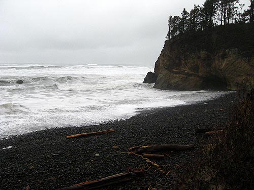
The beach’s prehistoric past sometimes comes to light during wild winters, as heavy wave action in some years scours out so much sand you can see the bedrock. Above, you see the gravel beds close to the cliffs, as one winter storm really started tearing away at this strand.
During such extremely low sand level winters, the bedrock shows off all manner of strange objects that hide beneath the normal 10 to 20 feet of sand: things like “red towers,” geologic wonders that look a bit like something between a Yes album cover and Dr. Seuss.
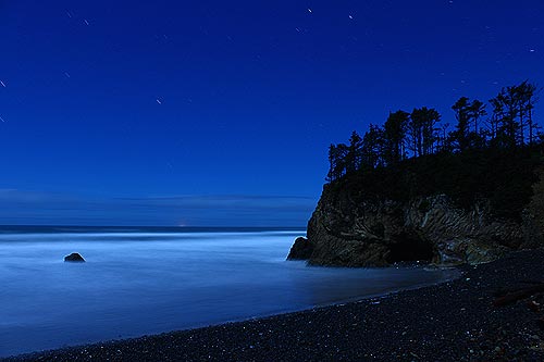
But at night, Hug Point is still resplendent in esoteric beauty, with star trails zipping around above it, and the ocean becomes a surreal mist because of the three-minute-long exposure needed to capture this haunting scene.
See the new Cannon Beach page on Facebook
More About Cannon Beach Dining, restaurants.....
More About Cannon Beach Lodging.....
 |
 |
 |
LATEST OREGON COAST NEWS STORIES
Whale Body Parts Found on Oregon Coast - Two Whales Strand on Washington Coast |
Back to Oregon Coast
Contact Advertise on BeachConnection.net
Secrets of the Season |
Unusual Travel Articles TravelParanormal.com allows you to submit your own creepy tale or debunk one - or see up-to-the-minute news headlines about travel and the paranormal. News Headlines from All Over Oregon Need to scan Oregon headlines? Constantly updated news from all over Oregon: a comprehensive, up-to-the-minute display of news headlines from a variety of media |


