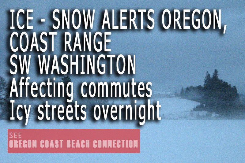
Deep Freeze for Washington, Oregon, Coast Range: Ice, Sleet Builds Today Into Friday
Published 02/13/25 at 7:59 a.m.
By Oregon Coast Beach Connection Staff
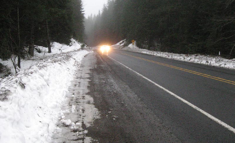
(Manzanita, Oregon) – Freezing rain and snow are about to impact most of Oregon and Washington over the next 24 hours, affecting the commute in many urban areas like Portland, Salem, Eugene and Corvallis. The Columbia Gorge and south to central Willamette Valley will get some of the worst of it, as tonight through early Friday will not inch above the freezing point, leaving whatever snow or ice that falls unable to melt.
Includes exclusive listings; some specials in winter
In Cannon Beach:
Includes rentals not listed anywhere else
In Manzanita, Wheeler, Rockaway Beach:
Some specials for winter
In Pacific City, Oceanside:
Some specials for winter
In Lincoln City:
Some specials for winter
In Depoe Bay, Gleneden Beach:
Some specials for winter
In Newport:
Look for some specials
In Waldport
Some specials for winter
In Yachats, Florence
Some specials for winter
Southern Oregon Coast Hotels / Lodgings
Reedsport to Brookings, places to stay; winter deals
“Freezing rain & snow will impact NW OR & SW WA late tonight/early tomorrow morning through Friday,” the National Weather Service (NWS) said. "Expect significant travel impacts on all roads. Localized power outages are possible, especially near the Columbia River Gorge & in the central/southern Willamette Valley.”
Areas along the coast won't get hit as hard and may mostly see rain, but valley and metro towns are going to see ice pile up later today after Thursday morning's commute, possibly leaving many unable to drive home.
The NWS has issued a wide range of warnings and advisories from Washington down through the vast majority of Oregon, while the south coast will see a high surf advisory.
- Washington Coast Weather - Oregon Coast Weather - Inland Oregon Weather
Central Oregon Coast Range, South Willamette Valley: Ice Storm Warning until 4 p.m. Friday. The areas around the central coast range, Woodburn, Salem through Silverton and Corvallis will see significant icing. In this region, the NWS said it is more likely than others to have ice build up on trees and perhaps cut out power.
“Travel is strongly discouraged, unless it is an emergency,” the NWS said.
Portland Metro Area through La Center, Washington, Troutdale, Lake Oswego and Oregon City: Winter Storm Warning until 10 a.m. Friday. Heavy mixes of snow, rain and sleet are expected with up to two tenths of an inch of ice. Winds gusting at 45 mph will add a severe wind chill. Ice may down power lines.
Winter Storm Warning: North Oregon Coast Range, Grand Ronde and Highway 6. It's a forecast similar to the Portland Metro area, but add in the upper elevations of the coast range and you'll see slicker roads.
Extreme Cold Warning turning to Cold Weather Advisory: Eastern Areas of Portland through Columbia Gorge. In effect from noon today through noon Friday. Expect icy roads, and the NWS warns “Dangerously cold wind chills ('feels like') as low as zero degrees fahrenheit expected.”
Winter Weather Advisory for North and Central Oregon Coast into SW Washington Coast, in effect until 4 p.m. Friday. The beach towns from Long Beach, Seaside, Cannon Beach, Lincoln City and Newport down through Florence will see the least icy issues, but some layers of ice are still possible, especially in upper elevations.
High Surf Advisories for South Oregon Coast (Coos Bay through Brookings), in effect until 2 p.m. Friday. “Large breaking waves will create hazardous conditions along and within the surf zone, and could inundate beaches and low lying shorelines,” the NWS said.
Oregon Coast Hotels - South Coast Hotels - Oregon Coast Vacation Rentals - Where to eat - Maps - Virtual Tours


Oregon Coast Vacation Rentals
Oregon Coast Lodging Specials

More About Oregon Coast hotels, lodging.....
More About Oregon Coast Restaurants, Dining.....


 Andre' GW Hagestedt is editor, owner and primary photographer / videographer of Oregon Coast Beach Connection, an online publication that sees over 1 million pageviews per month. He is also author of several books about the coast.
LATEST Related Oregon Coast Articles
Astoria's Riverwalk Gets New Lighting, More N. Oregon Coast RoadworkDelays coming this summer, but the riverwalk has a new look. Seaside, Cannn Beach
Surprise Oregon Coast Accesses at Yachats' Northern, Outer Edges
Glorious discoveries include where Yachats changes from sand to rock. Travel tips
Central Oregon Coast's Newport Bans Personal Fireworks
Lincoln County's Yachats, Waldport, and Lincoln City have slightly different bans. Newport events, beach safety
Astoria's Crab, Seafood, Wine Fest Floods N. Oregon Coast with Yumminess in A...
April 25 to 27 at the Clatsop County Fairgrounds. Astoria events, Cannon Beach events
Catching Another Side of Astoria: Ethereal Oregon Coast Scenery at Night
A photo essay: surreal city and maybe some Star Trek
South Oregon Coast's Golden and Silver Falls Park Needs Cleanup Volunteers
Saturday, May 24 at the park near Coos Bay, but Shore Acres also needs help. Coos Bay events
Florence Latest Oregon Coast Town to Add Mobi-Mats, Hearing Loops, More Acces...
Florence is increasing efforts to ensure fun for all guests. Travel tips
Spring's Weird Things Along Washington, Oregon Coast
Whale burps, ocean burps, freaky skeletons, mermaid purses, live eggs, more. Marine sciences
Back to Oregon Coast
Contact Advertise on Oregon Coast Beach Connection
All Content, unless otherwise attributed, copyright © Oregon Coast Beach Connection. Unauthorized use or publication is not permitted

Oregon
Coast Hotels
S. Coast Hotels
Astoria/Warrenton Hotels
Seaside Hotels
Cannon
Beach Hotels
Nehalem Bay Lodgings
Manzanita Hotels, Lodging
Rockaway Beach Hotels
Three Capes Lodging
Pacific City Hotels, Lodging
Lincoln
City Lodging
Depoe
Bay Hotels
Newport Hotels
Waldport Lodging
Yachats
Hotels
Florence Hotels
Reedsport Hotels
Coos Bay Hotels
Bandon Hotels
Port Orford Hotels
Gold Beach Hotels
Brookings Hotels
Oregon
Coast Vacation Rentals
Oregon
Coast Lodging Specials
South Coast Hotels
Dining
Guide
Seaside
Cannon
Beach Dining
Manzanita,
Rockaway, Wheeler Dining
Pacific
City, Oceanside, Netarts, Tierra Del Mar Restaurants
Tillamook
Bay Restaurants, Dining
Lincoln
City Dining, Restaurants
Depoe
Bay Restaurants, Dining
Newport Restaurants, Dining
Waldport,
Yachats Restaurants, Dining
Florence Restaurants, Dining
Restaurant
Reviews
Coast
Events Calendar
Astoria
Seaside,
Cannon Beach Calendar
Manzanita,
Rockaway Events
Tillamook,
Pacific City Calendar
Lincoln
City Events Calendar
Newport,
Depoe Bay Events Calendar
Yachats Events Calendar
Oregon Coast Complete Guides every beach access, attraction
Search for Oregon Coast Subjects, Articles
Explore Every Beach Spot


News Headlines from All Over Oregon Need to scan Oregon headlines? Constantly updated news from all over Oregon: a comprehensive, up-to-the-minute display of news headlines from a variety of media
Oregon Coast Oceanfront Lodging, Hotels, Rentals