Detour to Oceanside, Cape Meares Coming in August - Some N. Oregon Coast Traffic Affected
Published 7/23/24 at 7:55 p.m.
By Andre' GW Hagestedt, Oregon Coast Beach Connection

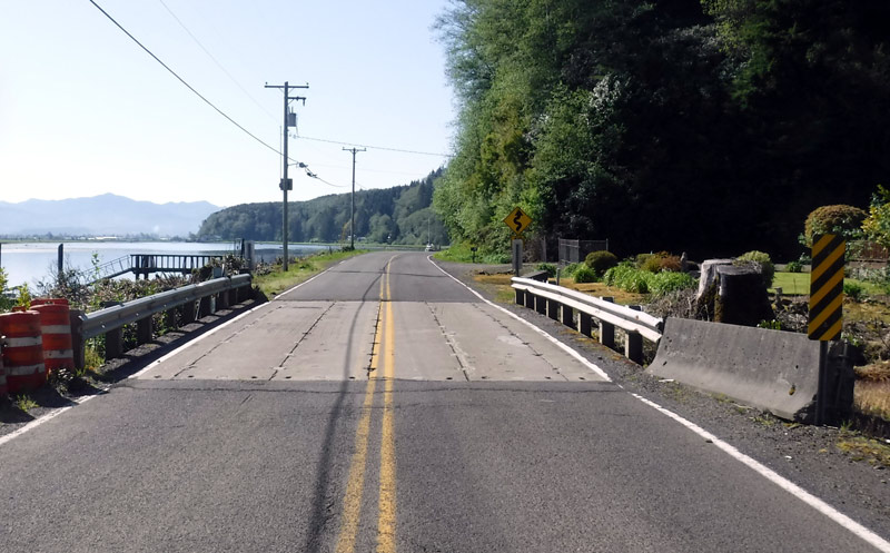
(Oceanside, Oregon) – A month of some amount of travel hassles is coming soon to a major north Oregon coast attraction, as one route between Oceanside and Tillamook will be cut off due to a major construction project. Bayocean Road will be closed in one area. Tillamook County and its tourism arm, Tillamook Coast Visitors Association (TCVA), announced the closure this week, saying it will take place August 5 through September 5. (Bayocean's beach / Oregon Coast Beach Connection)
Includes exclusive listings; some specials in winter
In Cannon Beach:
Includes rentals not listed anywhere else
In Manzanita, Wheeler, Rockaway Beach:
Some specials for winter
In Pacific City, Oceanside:
Some specials for winter
In Lincoln City:
Some specials for winter
In Depoe Bay, Gleneden Beach:
Some specials for winter
In Newport:
Look for some specials
In Waldport
Some specials for winter
In Yachats, Florence
Some specials for winter
Southern Oregon Coast Hotels / Lodgings
Reedsport to Brookings, places to stay; winter deals
The closure cuts off the quick route between Tillamook and Cape Meares, however the newly-reopened Three Capes Loop allows easy access to both towns. It simply takes a little longer coming from the north.
In December 2015, the culvert hosting Dick Creek on Bayocean Road blew out, necessitating the installation of a temporary bridge on this rather important north Oregon coast access route. Now, after thorough design and permitting processes, Tillamook County has selected a contractor to build a permanent bridge.
Here are the closure details:
Dates: The closure will be in effect from August 5th to September 5th.
Location: Specifically, the closure affects Bayocean Road at milepost 2.4, situated between the Memaloose Boat Launch and Bayocean Dike Road.
Courtesy TCVA
The closure won't be easier on those walking, either.
“No accommodations for pedestrian or bicycle traffic will be made during this closure period,” TCVA said.
There are some environmental constraints, TCVA said.
“The timing of the road closure is based on environmental limitations and cannot be accelerated,” the agency said. “However, the contractor will make every effort to reopen the road before Labor Day weekend.”
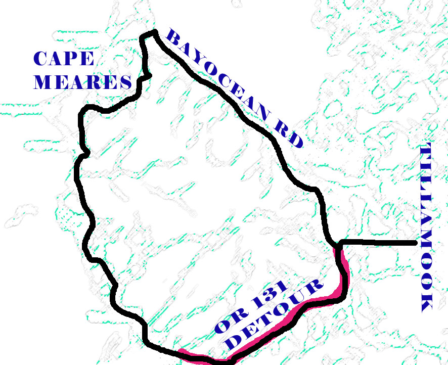
MAP OF BAYOCEAN ROAD / OR 131 DETOUR
To accommodate Oregon coast travelers during the closure, a detour route has been created:
Route: Take OR 131 to Oceanside, turn right onto Cape Meares Loop Road, and follow signs over the new alignment of Cape Meares Loop Road; this road intersects with Bayocean Road at Cape Meares Lake. Take a left to the community of Cape Meares or a right to access Bayocean Dike Road.
Signage: Detour signs will be installed to guide the traveling public.
Tillamook County said it appreciates the public's understanding and cooperation during this essential infrastructure improvement project.
“The new permanent bridge will enhance safety and accessibility for all travelers in the region,” ODOT said.
For any questions or further information, please contact Tillamook County Public Works at 503-842-3419.
Tillamook County last year announced the reopening of Cape Meares Loop Road, a crucial connector between Cape Meares and Oceanside, and the critical piece in restoring the historic Three Capes Scenic Route. This milestone followed a decade of dedicated efforts in design, funding, relocation, and construction after the road was closed in 2013 due to severe landslide damage.
The original Cape Meares Loop Road has faced challenges since 1877 when the first slides occurred. In November 2012, a significant landslide caused extensive damage, leading to the closure of the road in 2013. Cape Meares Loop Rd. Reopens, N. Oregon Coast's Three Capes is 'Loop' Again After 10 Years
Also happening right now: campfires have been temporarily banned in many Oregon state parks, mostly east of the Willamette Valley and Cascades. However, about all south Oregon coastal state parks have some kinds of fire bans as well, prohibiting campfires or fires in areas other than designated spots or fire rings. These include state parks at Bandon, Arizona Beach, Cape Arago, Cape Blanco near Port Orford, Samuel H. Boardman Scenic Corridor, Brookings and more. North and central coast parks are not listed at this time, although you should always check your destination if you're going camping. All Siuslaw National Forest areas have stricter bans. All Siuslaw National Forest Areas Under Fire Restrictions; South Oregon Coast Parks
MORE ON THIS AREA BELOW
Hotels in Three Capes - Where to eat - Three Capes Maps and Virtual Tours
Hotels in Oceanside - Where to eat - Oceanside Maps and Virtual Tours


Cannon Beach Lodging
Nehalem Bay Lodgings
Manzanita Hotels, Lodging
Three Capes Lodging
Pacific City Hotels, Lodging
Lincoln City Lodging
Depoe Bay Lodging
Newport Lodging
Waldport Lodging
Yachats Lodging
Oregon Coast Vacation Rentals
Oregon Coast Lodging Specials


More About Oregon Coast hotels, lodging.....
More About Oregon Coast Restaurants, Dining.....


 Andre' GW Hagestedt is editor, owner and primary photographer / videographer of Oregon Coast Beach Connection, an online publication that sees over 1 million pageviews per month. He is also author of several books about the coast.
LATEST Related Oregon Coast Articles
Above Oregon / Washington Coast in May: Meteors Peak, Galaxy Disappears - and...A sky full of possibilities this month, including a star that might explode. Sciences, astronomy
Oregon Coast Outdoors: Clamming, Crabbing, Surfing, Fishing, Boarding Deep Guide
The wilds of the coast and hang gliding, boating, mussels, hiking, fishing, crabbing, sandboarding, more. Sciences
Rugged Central Oregon Coast This Summer: Guided Pontoon Boat, Tidepool and Ca...
Lincoln City events every week: guided boat, tidepools gatherings, tours of Cascade Head. Lincoln City Exploriences. Click for schedule
Oregon Officials: What Not to Do Building Campfires on Coast, in Forests
Guidelines slightly different for coast vs inland. Weather
Newport's Oregon Coast Jazz Party Announces Lineup for 2025
October 3-5 in the Alice Silverman Theatre at Newport Performing Arts Center. Newport events
Whale Body Parts Found on Oregon Coast - Two Whales Strand on Washington Coast
One was a rare orca find; both suspected human interaction. Marine sciences
A Less Expensive May in Newport: Handful of Oregon Coast Inns Still Offering ...
Inn at Nye Beach, Nye Beach Cottages, Ocean House BnB: Newport hotel specials. Newport hotel reviews
Pacific City Oregon Weather, 7-Day Forecasts, Live Conditions, Radar, Webcams...
Updated Constantly: Pacific City, Tierra Del Mar, Oregon Weather, Cams, Buoy Observations, Tides, Warnings - Alerts
Back to Oregon Coast
Contact Advertise on Oregon Coast Beach Connection
All Content, unless otherwise attributed, copyright © Oregon Coast Beach Connection. Unauthorized use or publication is not permitted

Oregon
Coast Hotels
S. Coast Hotels
Astoria/Warrenton Hotels
Seaside Hotels
Cannon
Beach Hotels
Nehalem Bay Lodgings
Manzanita Hotels, Lodging
Rockaway Beach Hotels
Three Capes Lodging
Pacific City Hotels, Lodging
Lincoln
City Lodging
Depoe
Bay Hotels
Newport Hotels
Waldport Lodging
Yachats
Hotels
Florence Hotels
Reedsport Hotels
Coos Bay Hotels
Bandon Hotels
Port Orford Hotels
Gold Beach Hotels
Brookings Hotels
Oregon
Coast Vacation Rentals
Oregon
Coast Lodging Specials
South Coast Hotels
Dining
Guide
Seaside
Cannon
Beach Dining
Manzanita,
Rockaway, Wheeler Dining
Pacific
City, Oceanside, Netarts, Tierra Del Mar Restaurants
Tillamook
Bay Restaurants, Dining
Lincoln
City Dining, Restaurants
Depoe
Bay Restaurants, Dining
Newport Restaurants, Dining
Waldport,
Yachats Restaurants, Dining
Florence Restaurants, Dining
Restaurant
Reviews
Coast
Events Calendar
Astoria
Seaside,
Cannon Beach Calendar
Manzanita,
Rockaway Events
Tillamook,
Pacific City Calendar
Lincoln
City Events Calendar
Newport,
Depoe Bay Events Calendar
Yachats Events Calendar
Oregon Coast Complete Guides every beach access, attraction
Search for Oregon Coast Subjects, Articles
Explore Every Beach Spot


News Headlines from All Over Oregon Need to scan Oregon headlines? Constantly updated news from all over Oregon: a comprehensive, up-to-the-minute display of news headlines from a variety of media
Oregon Coast Oceanfront Lodging, Hotels, Rentals