History of North Oregon Coast Dunes Reads Like An Alien Movie
Published October 2008
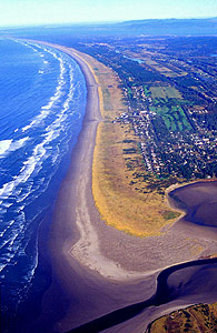 |
| Gearhart from above: the yellow dunegrass shows how the dunes have expanded in the area - a good 2000 feet of them. (photo Tom Horning) |
(Warrenton, Oregon) - It's a place on Earth invaded by an alien species. It's been taken over by giant, soft things as well, killing much of the native life in the area and completely changing the landscape so it could survive.
Sounds like an alien sci-fi flick, doesn't it? It's actually the north Oregon coast, from Seaside up to Warrenton. And the alien invaders we're talking about are invasive species of plants and the massive expansion of dunes we see all the time there - something always thought of as simply natural that belongs there.
Tom Horning, a geologist living in Seaside, says all of the area known as the Clatsop Plains is actually big foredunes, where originally it was grassy, prairie land with actual soil underneath. Now much of the area 100's of yards from the water is mostly sand.
Mankind changed that dynamic over 100 years ago, and thus drastically changed the landscape. Back then, and back when Lewis and Clark and crew first set foot in the area, huge chunks of land didn’t even exist, like many parts of what is now Fort Stevens State Park. It's a story of changes in river flow, ocean currents, invasive plant species, and more interference by humans. There's more to those dunes than pretty postcards: they're a testament to what happens when you screw with nature.
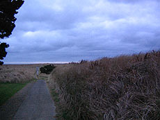 |
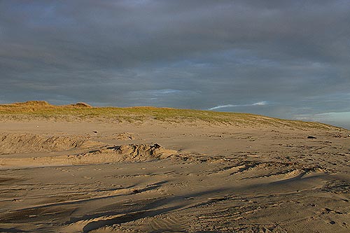
| Descending the dunes of Gearhart to the beach: it's quite a walk. |
Horning said old photos of Gearhart show the beach right below the houses along the west side of town. All of the dune, nearly 2000 ft of it, has developed since about 1900.
"In a nutshell, the dunes have been growing at a high rate since the Columbia River jetties were built around 1890," Horning said. "The jetties narrowed the wide-open mouth of the river by about 80 percent, from a pre-jetty width of about eight miles to less than two miles. This increased the ebb-tide flow of the river, and the increased currents swept sand out into deeper water, keeping the shipping channel considerably deeper than it had been."
As a result, fewer ships wrecked, an area called Peacock Spit enlarged, and dredging by the Army Corps of Engineers added more sand to the spit, forming a large ebb-tide delta outside the mouth of the river.
“In the earlier parts of the 20th century, Peacock Spit was so large that it frequently was exposed at low tide where fisherman played baseball, or so I have been told,” Horning said.
Peacock Spit eventually washed away, but it has served as a reservoir of sand for long-shore currents, which sweep north and south along the beaches on either side of the Columbia. Because the spit enlarged after construction of the jetties, more sand was swept south and north, and the beaches increased in width and height.
Then, winds blew even more sand into the dunes from the newer, wider beaches. So much sand blew into the dunes that the native vegetation was swamped and overrun by rampaging dunes.
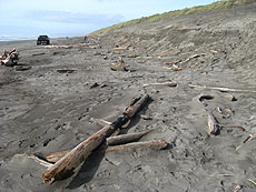 |
| Dunes and stuff at Fort Stevens' beach: most of the park didn't exist before the jetty changed the currents and sand distribution in the area. |
“Grazing lands in the grassy prairies of Clatsop Plains were buried under an advancing sheet of sand that extended hundreds of yards inland; courtesy of the Army Corps of Engineers, of course,” Horning said. “They are not to blame entirely, as dune rampage has been a common event in the history of Clatsop Plains, based on photos and maps prior to 1900 that show wide open prairies devoid of trees. Had sand not swept in periodically, the forests would have migrated out to the active dune line and trees would have been common throughout Clatsop Plains.”
The slow, rampaging march of dunes westward and eastward happened about the same time as the Dust Bowl drought of the 1930’s. The Soil Conservation Service was created then to combat poor agricultural practices, but it got ahead of itself out on the Oregon coast. Using lessons learned in the Midwest, they incorrectly concluded that Clatsop Plains had been overgrazed by ranchers, leading to uncontrolled “soil” loss and dune migration.
“The Civilian Conservation Corps was brought in and they planted shore pine, Scotch broom, and European beachgrass in the open dune areas to stabilize the blowing sands,” Horning said. “The results were highly successful, particularly because of the beachgrass, which thrives when buried under windblown sands of winter. The grasses were far more effective than the native American beachgrass at trapping the sands in its natural baffles and clumps.”
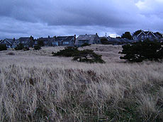 |
| Gearhart's dunes are covered in invasive species plants. |
These are invasive species, however. All this deprived the natural prairie of periodic sand drifts, letting the coastal pines along with the invasive plants spread even more.
Trees cannot grow well on the dunes area, but some have sprouted along the older dunes.
“Soon, the gorgeous natural prairie became overrun by the invasive broom and pines, and the great expanses of chocolate lilies, dune goldenrod, and yarrow retreated into a few remaining refuges,” Horning said. “Since then, Scotch broom has invaded all of western Oregon and Washington, spreading high into the Coast Range clear cuts.”
Horning said that until 1890, dunes had been growing westward by two to three feet per year. But with the introduction of invasive European beachgrass and the surge in sand supply from the newly enlarged ebb-tide delta of the Columbia, dune growth rates increased to over 35 ft per year horizontally and up to 3 ft per year vertically.
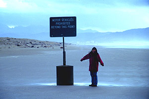 |
| Tom Horning took this photo of his wife standing next to a sign on the beach, to help show how much the sand has risen here. The top of the concrete holding the signpost was 11 feet tall back in 1970. |
“Since the jetties were built on the Columbia, the dune complex has grown westward as much as 2000 ft in places and to heights of as much as 45 ft,” Horning said. You can see that in a photo Horning took of his wife standing beneath a beach sign.
“When it was erected around 1970, the top of the concrete column was about 11 ft above the beach,” he said. “This shows how much the beach has risen.”
The tide, it seems, has begun to turn on the dunes, however. The growth rate has slowed in recent decades, down to expanding about 12 to 16 feet per year. Storms in recent years have cut away at the dunes quite dramatically, sometimes clipping them as much as 75 feet. Erosion is increasing in spots along the entire Oregon coast, including here, and that’s taking its toll on the dunes.
Like winter sand level erosion in Neskowin or the middle of Tillamook County beaches, this area too has been somewhat slow to restore itself during the warmer weather seasons when sand normally begins to pile up again.
“At some point in the future, it is likely that the dunes will begin to wash away and the shoreline retreat eastward,” Horning said.
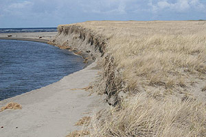 |
| An example of storm surge wave cut action on the dunes (photo Tom Horning). |
Horning said the supply of sand in the Columbia River and at the ocean bottom is beginning to thin, thanks to a lot of factors. It’s called the “sediment budget” of the beaches, river and the seafloor. Dredging in the Columbia has been part of the cause, and the dams upstream along the Columbia prevent sediments from washing into the ocean.
“Dune retreat has already begun on the Washington side of the river, particularly near North Head, where the beaches are being cut back from 5 to 10 ft per year,” Horning said. “In due course, the south part of the Long Beach Peninsula will see as much as 1000 ft of shoreline retreat. Sadly for them, they are beginning to allow construction close to the ocean.
“You will one day hear about homes washing into the surf.”
More About Seaside, Oregon Coast hotels, lodging.....
More About Oregon Coast Restaurants, Dining.....


LATEST Related Oregon Coast Articles
The sixth in the NW in three weeks; early indications suggest it may have been undernourished. Marine sciences
Now Begins the 'Season of Satellites' Above Oregon, Washington: Summer's Surr...
Not even counting meteors, these satellite trains can create wild colors and streaks in the sky. Astronomy, weather. Brookings events, Gold Beach events, Port Orford events, Coos Bay events, Bandon events, Florence events, Yachats events, Newport events, Lincoln City events, Rockaway Beach events, Manzanita events, Cannon Beach events, Seaside events, Astoria events
7-Day Parking Meters Return to Central Oregon Coast Town, and Now to Nye Beac...
Newport?s Bayfront will charge all week, and the Nye Beach Turnaround will now do the same. Travel tips, traffic
87th Annual Azalea Fest Readies Its Return for Memorial Day Weekend on S. Ore...
Brookings brings back the long-running festival over Memorial Day weekend, May 22?25. Brookings events
Harrowing Accident Scene on S. Oregon Coast Turns Into Search for Driver and ...
Sheriffs found an empty vehicle and searched nearly 24 hours before locating the driver. Traffic
Another Dead Whale Stranding, This Time Near Yachats on Central Oregon Coast
Reports differ on whether it was alive at first; scientists are examining the carcass. Marine sciences
Washington Coast Cleanup Scours Inner and Outer Coast, April 25
Volunteers are needed along the outer coast and throughout the Salish Sea. Washington coast events
4th of July at N. Oregon Coast's Sand Lake Now Requires Pre-Sales for Camping...
Congestion and overcrowding in recent years at Sand Lake Recreation Area near Pacific City. Traffic, travel tips
Back to Oregon Coast
Contact Advertise on BeachConnection.net
All Content, unless otherwise attributed, copyright BeachConnection.net Unauthorized use or publication is not permitted
Oregon
Coast Lodging
Rentals
Specials
Search for Oregon Coast Subjects, Articles
Virtual Tours, Maps
Deep Details


Oregon
Coast Lodging
Seaside
Cannon
Beach Lodging
Nehalem Bay Lodgings
Manzanita Hotels, Lodging
Rockaway Beach Hotels
Three Capes Lodging
Pacific City Hotels, Lodging
Lincoln
City Lodging
Depoe
Bay Lodging
Newport Lodging
Waldport Lodging
Yachats
Lodging
Oregon
Coast Vacation Rentals
Oregon
Coast Lodging Specials
Dining
Guide
Seaside
Cannon
Beach Dining
Manzanita,
Rockaway, Wheeler Dining
Pacific
City, Oceanside, Netarts, Tierra Del Mar Restaurants
Tillamook
Bay Restaurants, Dining
Lincoln
City Dining, Restaurants
Depoe
Bay Restaurants, Dining
Newport Restaurants, Dining
Waldport,
Yachats Restaurants, Dining
Florence Restaurants, Dining
Restaurant
Reviews
Coast
Events Calendar
Astoria
Seaside,
Cannon Beach Calendar
Manzanita,
Rockaway Events
Tillamook,
Pacific City Calendar
Lincoln
City Events Calendar
Newport,
Depoe Bay Events Calendar
Yachats Events Calendar
Oregon Coast Complete Guides every beach access, attraction
Search for Oregon Coast Subjects, Articles
Explore Every Beach Spot


News Headlines from All Over Oregon Need to scan Oregon headlines? Constantly updated news from all over Oregon: a comprehensive, up-to-the-minute display of news headlines from a variety of media
Oregon Coast Oceanfront Lodging, Hotels, Rentals