End in Sight for Oregon Coast Flooding; More Warnings for Saturday
Published 12/11/2015 at 8:43 PM PDT
By Oregon Coast Beach Connection staff
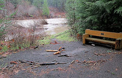
(Oregon Coast) – More flood, wind and high surf warnings have been issued for the Oregon coast through Saturday, but an end may be near. Rain will back off Sunday and dry up for a couple days, while another set of storms will come in later, although not as heavy. (Above: flooding and damage at the Tillamook Forestry Center).
Meteorologist Liana Brackett, with the National Weather Service (NWS) in Portland, said things are starting look up.
“We are not expecting floods on Sunday,” Brackett said. “Seas will not be as high.”
Another round of rainy, windy weather comes in later on Sunday night, but by late Monday over Tuesday the NWS is expecting drier conditions.
On Wednesday, however, more storms come in and stay through next weekend - about three new systems, Brackett said. These will move through the area more quickly, bringing a good chance they won't cause any significant problems. However, she added there is the possibility of more flooding, depending on how saturated the soils of the area get.
Brackett also noted those systems will generally be south of Tillamook and mostly leave the northern part of the Oregon coast alone.
This also begged the question: does this kind of stormy inundation fit into the model of an El Nino, especially the kind of which this region is experiencing? This weather pattern normally results in warmer temperatures and drier conditions.
Brackett said it is not a hard and fast rule, but rather a general trend.
“Next summer, if we're looking back at December, we'll probably see the general trend was drier,” Brackett said.
This could still mean a more temperate and slightly sunnier overall trend for the winter, turning back around the now-slightly injured tourism industry.
A high wind watch is in effect from Saturday morning until the late Sunday afternoon, with gusts in the 50's and maybe 60's on the north and central Oregon coast. Lincoln County will likely see this first before the storm moves northward, including towns such as Depoe Bay, Lincoln City, Newport and Yachats, .
More high surf warnings and coastal flood watches were issued by the NWS until 3 p.m. Saturday. Saturated soils, swollen rivers and big tides will likely cause some flooding.
More big breakers, likely above the 20-foot level, are in store for the weekend.
These make for awesome storm watching conditions, and tourism officials usually urge people to come out and see the drama. This time, however, the Tillamook Visitors Center is not doing so.
“Normally we would encourage visitors to come and storm-watch with us, but not this week, what with road closures and flooding,” the agency said.
The biggest road closure is currently at the southern end of Wheeler, according to Wheeler on the Bay Lodge. Traffic is cut off from the north to Rockaway Beach or Tillamook. However, a work-around opened up today with Miami-Foley Road getting cleared out. This detour involves using Highway 53 to connect with Miami-Foley Road, which meets up with Highway 101 at Garibaldi. More Oregon Coast Weather
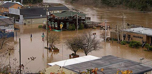
Flooding in Nehalem this week - photo Julee Ward
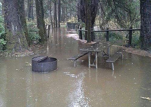
Beverly Beach flooding - near Newport. Photo courtesy Oregon State Parks
Video: high surf at Pacific City
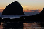
High Surf Pacific CityA little of today's high surf action at Cape Kiwanda, looking at Haystack Rock, in Pacific City. By Ralph Barajas. (Thanks, Ralph.)
Posted by Tillamook County Pioneer on Friday, December 11, 2015
Below: large waves at Lincoln City, log that broke a picnic table
Nelscott Beach access, Lincoln City, OR 2 hours before high tide 12-11-15
Posted by Rock Your World: Pacific NW Gem & Jewelry Gallery on Friday, December 11, 2015
More About Oregon Coast hotels, lodging.....
More About Oregon Coast Restaurants, Dining.....
Cannon Beach Lodging
Nehalem Bay Lodgings
Manzanita Hotels, Lodging
Three Capes Lodging
Pacific City Hotels, Lodging
Lincoln City Lodging
Depoe Bay Lodging
Newport Lodging
Waldport Lodging
Yachats Lodging
Oregon Coast Vacation Rentals
Oregon Coast Lodging Specials
LATEST Related Oregon Coast Articles
Likely just before dawn best hour but peak happens during daylight. Weather
Dark Sky Week is Prime Along Oregon Coast: Where and Where Not to Go
General guide to dark sky viewing from south to north coast. Astronomy
Sizable Price Drop, Deals in Lincoln City During Quiet of April on Central Or...
20 perc off at A1 Vacation Rentals across its roster, including Gleneden Beach. Lincoln City specials
Upcoming S. Oregon Coast Events Include Gem Show, History: Coos Bay, Bandon
May 6 talk at Coos History Museum, Mayfly Fest May 17, Bandon Rock / Gem Show June 7,8
Washington Coast Cleanup on April 19 - Coinciding with Oregon Coast's SOLVE E...
From the Puget Sound to Long Beach, alongside Oregon's cleanup. Washington coast events, Seaside events
Astoria's Riverwalk Gets New Lighting, More N. Oregon Coast Roadwork
Delays coming this summer, but the riverwalk has a new look. Seaside, Cannn Beach
April Gets Even Cheaper Midweek at Depoe Bay, Lincoln City: Oregon Coast Deals
Off-season rates plus more at Keystone Vacation Rentals. Depoe Bay lodging specials, Lincoln City hotel reviews, Newport hotel reviews
Washington Coast Begins Week of Clam Digs, April 12 Through 18
Long Beach, Twin Harbors, Mocrocks and Copalis at different times. Washington coast events
Back to Oregon Coast
Contact Advertise on BeachConnection.net
All Content, unless otherwise attributed, copyright BeachConnection.net Unauthorized use or publication is not permitted


