 |
A Research Expedition on Oregon Beaches
Published 2006
By Andre’ Hagestedt
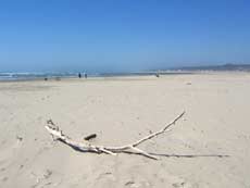 |
| Pristine sands of Patterson |
(Oregon Coast) – One research trip, some 25 miles of manic exploration. My obsession with coastal details, and the need for some more information on one certain stretch of Oregon coast, leads me on a frenzied tour of the area between Yachats and Florence, rooting out the hidden spots, documenting the minutiae and digging deeper and deeper into this area than I’ve ever been in some spots. New secret accesses are unearthed, new beaches are explored, startling discoveries are made – and then I apparently spooked a couple in the throes of passion on one clandestine beach.
There’s a heat wave in the valley, and I’m more than glad to be away from our Portland office, which is sweltering in 100-degree temps. So, bummer, it’s time to play on the coast for a few days, catch up on some work on the central coast, and do a lot of exploration.
Starting in out in Newport, I make my to Waldport, where Alsea Bay is a deep blue, with the sun beating down on the placid waters and a boat buzzing about. Just up the road, Governor Patterson State Park is the center of attention with a smattering of beachcombers, where the bright white, fluffy sands and blue sky make the place look a little tropical.
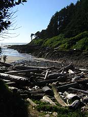 |
| Cape Cove Beach, w/ the backside of Cape Perpetua |
Zipping through Yachats and past Cape Perpetua and the Devil’s Churn just below it, I spot a trailhead I’d never seen before, perhaps 100 feet north of Cook’s Chasm (which is relatively quiet today, in spite of heavy winds in some spots here which are creating a surly sea and big waves). This clifftop reveals interesting new views of the southern side of Cape Perpetua, where a labyrinth of rocky slabs dots the wet sands, providing a few hundred feet of beach at a place I discover is called Cape Cove Beach. A mostly paved path winds its way down here.
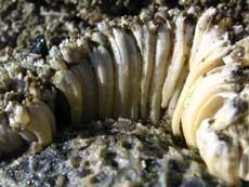
This little cove runs a ways into the cliffs, ending at a stream that pours from the earth. The tide has recently been very close to the inside end of this cove, as evidence of tiny sea creatures in great numbers still remains. But in the past, powerful storms have obviously deposited enormous logs right up to the edge of the mouth of the stream, some 100 feet from the tide line on this day. The frightening supremacy of the sea is clear here.
 |
| Sea life at bottom of Cape Perpetua |
Today, the tide is out pretty far, and you can see bundles of sea life at the foot of Cape Perpetua that’s normally underwater. Even among the rocky slabs at the southern end of the beach, many of these are usually beneath the tide line. Strange geologic features dot this place everywhere. I can’t wait to talk to my geologist sources on this.
The ocean is rather warm in spots on this beach. While occasionally wading in the water, loitering around one of these rock structures, I’m photographing various objects and sea life. From somewhere among these blobs, a young couple emerges, looking a little sheepish, brushing sand off themselves, and the girl is adjusting her skirt.
Apparently, they thought this beach was more unpopulated than it was, and they must have somehow spotted me wandering around the waves nearby, although I didn’t see them – or whatever it was they were doing.
Ah, to be young again.
 |
| Top of Cape Perpetua, as seen from below |
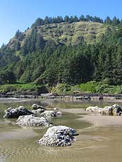
I make the remarkable discovery I can see the top of Cape Perpetua and its stone viewpoints from here, where I’ve been numerous times before, looking down on miles and miles of coastline. I zoom in with my camera and take a snapshot of this spot – from the vantage point of being below it.
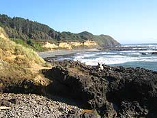
Back on the road, Strawberry Hill in the sunlight reveals more of the intriguing stone features that dot the landscape, interspersed with the tracts of hard sand and soothing surf. From here, I follow 101 south and the beaches below, trying to figure out where the next beach access is. More of these rocky slabs cover the landscape, especially as I photograph the beaches from above at an overlook called Bray’s Point, and it’s hard to say if all these basalt structures are completely traversable. It’s my job to find out if one can walk this entire way from one beach access to the next, but it looks likely the beaches can’t be reached from the southern end of Strawberry Hill, though I am not positive.
 |
| Strawberry Hill and the vastness to the south |
The nearest access appears to be a good mile down the road, south of here, at Ten Mile Creek. Everything else is private beach access, it seems. Yet the beach in this stretch is one gem of a walk, with lots of empty sandy spots, interspersed with the basalt chunks and boulder-like objects, where tide pools with little critters far outnumber the humans in the neighborhood.
Then it’s time to explore Ten Mile Creek and its accesses. On the southern side of the creek lies the dunesy-yet-rocky Stonefield Beach. This is one interesting spot, where wispy dunes and drifts are encroaching on the parking lot, giving way to more hard packed sand near the tide line, and then at its southern end sit a tract of basalt structures where the character of the sand changes drastically into large, coarse granules mixed with a host of other ground-down sea debris, like tiny bits of shells. Crossing the creek isn’t advisable, however, as even the current is extremely strong – or it’s too deep in other spots.
 |
| North side of Ten Mile Creek |
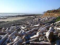
So, on the northern side lies this unreachable mile worth of beach, unless you’re staying at one of the lodgings along there or the RV park. Except there is a secret access on the north side of the Ten Mile Creek bridge. This I bump into, having documented it ten years ago, but I had loads of trouble finding it this time. It takes you on a long, winding path through brush, eventually giving way to a more manicured, grassy walk, snaking past a wild little lodging called The Ziggurat, which looks like a giant Rubik’s Cube twisted at odd angles.
Down on the beach, there are bubbly basalt structures dotting the landscape, and that creek gurgles away nearby, deceptively quiet for all the power within.
Down the road, Rock Creek Campground and the beach there provide more clandestine fun in the sand, with one long stretch of strand apparently unreachable by anything but the campground, or a hidden access on the north side of Big Creek, about a mile down.
However, I discovered a small hidden access in between, set inside a tiny little gravel pullout, where you have to snake through a narrow slit in the bushes to find yourself on the pastoral fore dune, which then takes you to the glittering, pristine sands of this area. It’s trippy and a little claustrophobic, but worth it, especially as you emerge from the bushes and the coastal vista explodes out in front of you.
Across Big Creek and bridge is another chunk of coastline, but no access to the southern beach is apparent. Yet the beautifully sculpted – albeit neglected – Muriel O. Ponsler Wayside is about a quarter mile south, so it’s not a long walk from there to the south side of Big Creek. Here, at Ponsler, the landscape begins to turn to that sandy, flat makeup, without the rocky interruptions, that’s indicative of the beaches of Florence – some 10 miles away now.
The sun is waning at this point, turning the landscape and sky to various shades of orange and red. The rounded sandstone cliff structure visible from both Ponsler and Big Creek has a cast to it now.
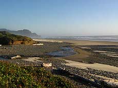 |
| Big Creek |
There is sizable construction going on now between Yachats and Strawberry Hill after 7 p.m., causing all sorts of backups after that hour, so it’s a slow drive back to a packed Yachats – so full of hungry diners I can’t find a restaurant available within the next 40 minutes.
The day ends with a frantic zip to Waldport, grabbing some spaghetti to go, and downing it in a face-slapping wind at Governor Patterson State Park, as the sun dips slowly into oblivion, and the howling winds drop sand into my Italian grub.
Whatever, I think to myself: It gives the spaghetti a seafood vibe.
More About Oregon Coast hotels, lodging.....
More About Oregon Coast Restaurants, Dining.....
 |
 |
Keywords: geology, cape kiwanda, topography, geography, fossils, Pacific City, Cannon Beach, Yachats, Depoe Bay, Newport, Lincoln City, Oceanside, Astoria, Oregon coast, science.
LATEST OREGON COAST NEWS STORIES
Back to Oregon Coast
Contact Advertise on BeachConnection.net
All Content, unless otherwise attributed, copyright BeachConnection.net Unauthorized use or publication is not permitted
Secrets of the Season |
Unusual Travel Articles TravelParanormal.com allows you to submit your own creepy tale or debunk one - or see up-to-the-minute news headlines about travel and the paranormal. News Headlines from All Over Oregon Need to scan Oregon headlines? Constantly updated news from all over Oregon: a comprehensive, up-to-the-minute display of news headlines from a variety of media |


