Four Fantastic Scenic Corridors of Oregon Coast
Published 12/20/21 at 6:02 PM PST
By Oregon Coast Beach Connection staff
Includes exclusive listings; some specials in winter
In Cannon Beach:
Includes rentals not listed anywhere else
In Manzanita, Wheeler, Rockaway Beach:
Some specials for winter
In Pacific City, Oceanside:
Some specials for winter
In Lincoln City:
Some specials for winter
In Depoe Bay, Gleneden Beach:
Some specials for winter
In Newport:
Look for some specials
In Waldport
Some specials for winter
In Yachats, Florence
Some specials for winter
Southern Oregon Coast Hotels / Lodgings
Reedsport to Brookings, places to stay; winter deals
(Oregon Coast) – Sometimes they have the name “scenic corridor” already, other times they are that unique brand of Oregon coastline that provides a run of non-stop views and beachy marvels in one way or another. But what's in a name, anyway? (Above: Samuel H. Boardman Scenic Corridor, courtesy Manuela Durson Fine Arts)
They are the fantastic scenic corridors of these shores, where you can often simply drive along and catch sight of the most unique spots that the coast can cloister, hiding plenty of things you've never seen before.
Bandon State Natural Area is not so much a scenic drive as it is a four-mile stretch of south Oregon coast wilderness and accesses that vary from well-known to absolutely secretive and remote.
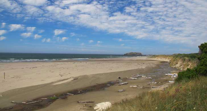
Photo courtesy Oregon State Parks
It all starts at the southern edge of Devil's Kitchen, where the vast majority of the activity along this chunk of untamed chunk of coastline takes place. It's here where the most variety of fun stuff is situated as well, with ancient sea stacks dotting the surf, in the shapes of blobs, spires to nebulous forms that defy description. Many have even more intricate features when you look close, such as large chunks of areas with bizarre honeycombed holes.
Climb on them or dart between them with your beach bike or horse ride.
Beach Loop Road is the mainline for accesses around here, with a couple of them within a mile south of Devil's Kitchen. China Creek at the southern elbow of the road is the last one for miles. From here on out there are no access points, almost three miles of remote hiking.
Along the way, the craggy, looming sea stacks have long disappeared, but a handful of odd structures lurk along the beaches. Mostly, it's pure, untouched no-man's land and sand, however, with the only access still miles away about Floras Lake – long after the Bandon State Natural Area has ended. South Coast Hotels - Where to eat - Maps - Virtual Tours
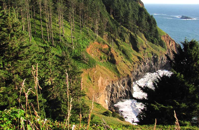
Upper Lane County. On the central Oregon coast, that 15 or so miles between Heceta Head and Yachats provide some of the most eye-popping scenery as seen from your car as can ever be imagined. With major bends in the road at various points, it's a tad white-knuckled at times, but on others there are long, straight stretches where you can gaze peacefully out at ocean vistas and curious shapes whizzing by. Plus, some of the most interesting beach access on the whole of the coast hide here. (Above: Strawberry Hill)
Ocean Beach Picnic Ground, closer to Florence, hosts a giant blob of a promontory, where plenty of sea life resides. Strawberry Hill is a vast complex of rocky chunks and placid beach to wander, where the sights get stranger the farther in you go, sometimes resembling a Yes album cover. Bray's Point allows you to stop and gawk at the oceanscape from above, while directly below it, Bob Creek hosts prime agate-combing, hordes of sea life and a funky cave. Hotels in Yachats - Where to eat - Upper Lane County Maps and Virtual Tours
Otter Crest Loop, near Depoe Bay. Barely a mile of roadway, still, it's one stunning little hidden drive that meanders, twists and turns beneath the main section of Highway 101 between Depoe Bay and the Devil's Punchbowl. No longer a loop, it was once fully two lanes, but about 20 years ago one lane kept disappearing into the plunging cliffs thus shutting it down with every two or three storm seasons, so officials finally whittled it down to one way for a good portion.
Starting at Rodea Point near Depoe Bay – or the Devil's Punchbowl, depending on how you think of it – there's a huge array of views that pop up in between stands of trees or bulbous, grass-covered hills. Glimpses of vast ocean are sandwiched between those engaging green blobs or mini-forests, with its undulating shapes almost taking on a kind of Celtic myth vibe.
These often give way to dramatically sheer cliffs, containing secret, chaotic shorelines that you can never get to, but you can watch them from afar.
Otter Crest Loop Road does have one incredibly cool secret access, however. Hotels in Depoe Bay - Where to eat - Depoe Bay Maps and Virtual Tours
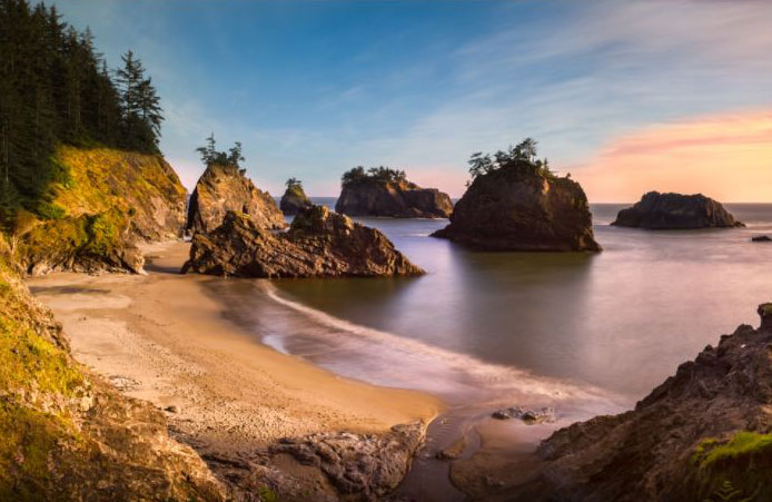
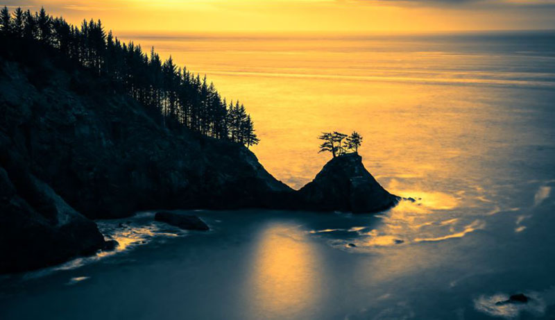
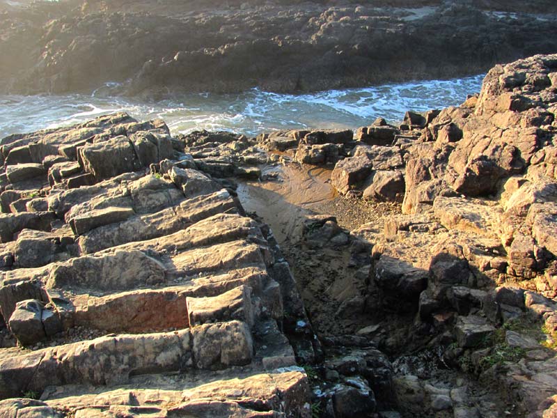
Samuel H. Boardman Scenic Corridor. The Samuel H. Boardman Scenic Corridor stretches some 25 miles down the southern Oregon coast, encompassing an unusually large portion of the drive from Gold Beach down to Brookings. Thus, it's no surprise there's a veritable laundry list of oceanic must-see's. (Above: Secret Beach, courtesy Manuela Durson)
Among the attractions here are Arch Rock Picnic Area, Spruce Island Viewpoint, Secret Beach, Seal Cove, the Natural Bridges, Spruce Creek area, China Beach, Thomas Creek Bridge, Indian Sands Loop Trail, Whaleshead Beach and Viewpoint, House Rock Viewpoint, Lone Ranch, and Cape Ferrelo.
Some of these spots are huge and meandering, especially the Natural Bridges area, where odd rock islands sit distanced from each other the majority of the time, while others have curious rocky walkways connecting them. In fact, what's going on here isn't quite what you'd imagine, geologically. Those arches and bridges are formed by giant caves falling apart, then leaving skeletal remains of sorts, in a rocky way. These aren't basalt (long ago-cooled lava), after all, like most of the northern half of the coast. What you see here is all sorts of looser, less sturdy material, normally conglomerates: meaning there's a mix of the stuff in the rocks you see.
The Natural Bridges is not an easy hike, but it's worth the exceptionally steep parts. South Coast Hotels - Where to eat - Maps - Virtual Tours


Cannon Beach Lodging
Nehalem Bay Lodgings
Manzanita Hotels, Lodging
Three Capes Lodging
Pacific City Hotels, Lodging
Lincoln City Lodging
Depoe Bay Lodging
Newport Lodging
Waldport Lodging
Yachats Lodging
Oregon Coast Vacation Rentals
Oregon Coast Lodging Specials

More About Oregon Coast hotels, lodging.....
More About Oregon Coast Restaurants, Dining.....


LATEST Related Oregon Coast Articles
The sixth in the NW in three weeks; early indications suggest it may have been undernourished. Marine sciences
Now Begins the 'Season of Satellites' Above Oregon, Washington: Summer's Surr...
Not even counting meteors, these satellite trains can create wild colors and streaks in the sky. Astronomy, weather. Brookings events, Gold Beach events, Port Orford events, Coos Bay events, Bandon events, Florence events, Yachats events, Newport events, Lincoln City events, Rockaway Beach events, Manzanita events, Cannon Beach events, Seaside events, Astoria events
7-Day Parking Meters Return to Central Oregon Coast Town, and Now to Nye Beac...
Newport?s Bayfront will charge all week, and the Nye Beach Turnaround will now do the same. Travel tips, traffic
87th Annual Azalea Fest Readies Its Return for Memorial Day Weekend on S. Ore...
Brookings brings back the long-running festival over Memorial Day weekend, May 22?25. Brookings events
Harrowing Accident Scene on S. Oregon Coast Turns Into Search for Driver and ...
Sheriffs found an empty vehicle and searched nearly 24 hours before locating the driver. Traffic
Another Dead Whale Stranding, This Time Near Yachats on Central Oregon Coast
Reports differ on whether it was alive at first; scientists are examining the carcass. Marine sciences
Washington Coast Cleanup Scours Inner and Outer Coast, April 25
Volunteers are needed along the outer coast and throughout the Salish Sea. Washington coast events
4th of July at N. Oregon Coast's Sand Lake Now Requires Pre-Sales for Camping...
Congestion and overcrowding in recent years at Sand Lake Recreation Area near Pacific City. Traffic, travel tips
Back to Oregon Coast
Contact Advertise on BeachConnection.net
All Content, unless otherwise attributed, copyright BeachConnection.net Unauthorized use or publication is not permitted

Oregon
Coast Hotels
S. Coast Hotels
Seaside Hotels
Cannon
Beach Hotels
Nehalem Bay Lodgings
Manzanita Hotels, Lodging
Rockaway Beach Hotels
Three Capes Lodging
Pacific City Hotels, Lodging
Lincoln
City Lodging
Depoe
Bay Hotels
Newport Hotels
Waldport Lodging
Yachats
Lodging
Oregon
Coast Vacation Rentals
Oregon
Coast Lodging Specials
South Coast Hotels
Dining
Guide
Seaside
Cannon
Beach Dining
Manzanita,
Rockaway, Wheeler Dining
Pacific
City, Oceanside, Netarts, Tierra Del Mar Restaurants
Tillamook
Bay Restaurants, Dining
Lincoln
City Dining, Restaurants
Depoe
Bay Restaurants, Dining
Newport Restaurants, Dining
Waldport,
Yachats Restaurants, Dining
Florence Restaurants, Dining
Restaurant
Reviews
Coast
Events Calendar
Astoria
Seaside,
Cannon Beach Calendar
Manzanita,
Rockaway Events
Tillamook,
Pacific City Calendar
Lincoln
City Events Calendar
Newport,
Depoe Bay Events Calendar
Yachats Events Calendar
Oregon Coast Complete Guides every beach access, attraction
Search for Oregon Coast Subjects, Articles
Explore Every Beach Spot


News Headlines from All Over Oregon Need to scan Oregon headlines? Constantly updated news from all over Oregon: a comprehensive, up-to-the-minute display of news headlines from a variety of media
Oregon Coast Oceanfront Lodging, Hotels, Rentals
Book Coastal Lodging Now
Booking.com