UPDATES: Flood Watches from Oregon, Washington Coastlines to Cascades - High Winds, Surf Warnings
Published 02/23/25 at 4:55 a.m.
By Oregon Coast Beach Connection Staff
(Portland, Oregon) – [UPDATES WITH NEW ALERTS IN OREGON, WASHINGTON] - A really wet weekend is in store for the western half of Oregon and Washington with a flood watch from the coast to the Cascades through at least Sunday or Monday, depending on where. The southern half of the Oregon coast is also under a high wind watch, with gusts up to 65 mph possible. (Photo Lincoln City Police Department).
Includes exclusive listings; some specials in winter
In Cannon Beach:
Includes rentals not listed anywhere else
In Manzanita, Wheeler, Rockaway Beach:
Some specials for winter
In Pacific City, Oceanside:
Some specials for winter
In Lincoln City:
Some specials for winter
In Depoe Bay, Gleneden Beach:
Some specials for winter
In Newport:
Look for some specials
In Waldport
Some specials for winter
In Yachats, Florence
Some specials for winter
Southern Oregon Coast Hotels / Lodgings
Reedsport to Brookings, places to stay; winter deals
Additions and Changes to Forecast Alerts:
High Surf Advisory South Oregon Coast is now a High Surf Warning, in effect Monday and Tuesday for Port Orford, Bandon, Coos Bay, Reedsport and Florence. Dangerously large breaking waves of 27 to 32 feet.
High Surf Advisory Added to North Oregon Coast, South Washington Coast. “Large waves and hazardous surf conditions. Breakers up to 35 feet,” the NWS said. This is for Yachats, Newport, Lincoln City, Pacific City, Rockaway Beach, Manzanita, Cannon Beach, Seaside, Long Beach, Ocean Shores.
Avalanche Alert has been issued for the Cascades of Oregon and Washington. Wet snow and rains have greatly increased those chances in the region.
All other prior alerts remain the same.
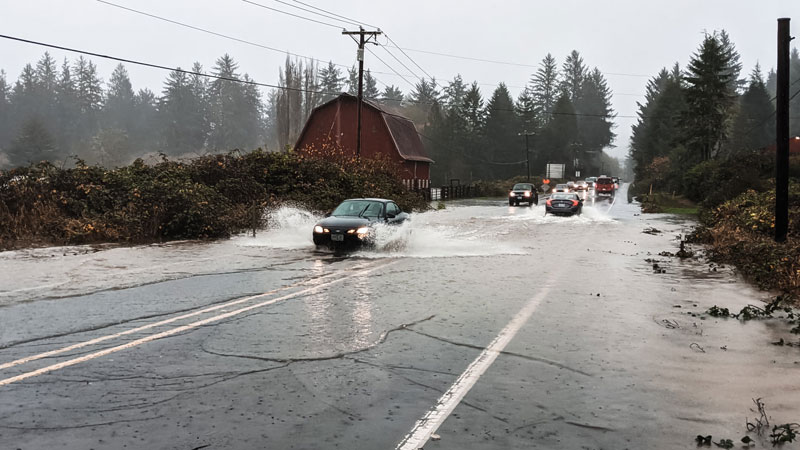
A massive chunk of the state is under a flood watch issued by the National Weather Service (NWS) in effect until Monday or Tuesday. Everything from Ocean Park, Washington down through Florence, and from Rockaway Beach, the Portland area, Newberg, Corvallis and into the Columbia Gorge is under that watch that is in effect until late Tuesday night. Also under a flood watch with a similar timing is everything in the western half of Washington, including Seattle, Everett and Marysville.
Fairly high winds are expected in the rest of the two western states, but not as high as the south coast.
A flood watch for the south Oregon coast (including Coos Bay, Port Orford, etc) has been issued until Monday morning.
The flood watches mean excessive runoff may result in rivers and streams flooding an area, especially those rivers draining from the Oregon Coast Range and Willapa Hills. Drainage systems may get overloaded causing flooded streets. Landslides may occur, the NWS said.
- Washington Coast Weather - Oregon Coast Weather - Inland Oregon Weather
The Cascades may be more vulnerable because of snowmelt on top of the heavy rains.
“Visible satellite imagery this afternoon shows a very clear picture of the atmospheric river approaching the Pacific Northwest with a stream of moisture and clouds stretching all the way from the coast out through the Pacific Ocean to west of Hawaii,” the NWS said. “Multiple frontal systems will move through the region through Monday, bringing multiple rounds of precipitation associated with the
atmospheric river.”

The heaviest rainfall looks to happen on Sunday.
“Expect rainfall totals from this evening through Sunday morning to range from 1.25-2.50 inches for coastal areas and the higher terrain, with amounts approaching 1 inch in the interior lowlands,” the NWS said.
They expect a lull between systems on Sunday night, but that could well be just the calm before the next storm.
The high wind watch for the south Oregon coast is in effect throughout Monday. South winds of 35 to 45 mph are possible, along with gusts up to 65 mph. MORE STORM PHOTOS BELOW
Oregon Coast Hotels in this area - South Coast Hotels - Oregon Coast Vacation Rentals - Where to eat - Maps - Virtual Tours


Oregon Coast Vacation Rentals
Oregon Coast Lodging Specials


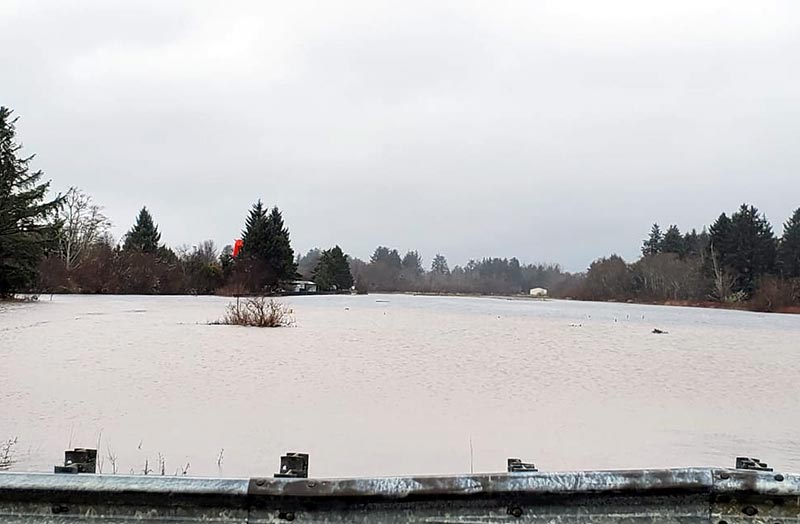
Courtesy Angi D Wildt Gallery - flooding at Seaside

Courtesy ODOT
More About Oregon Coast hotels, lodging.....
More About Oregon Coast Restaurants, Dining.....


 Andre' GW Hagestedt is editor, owner and primary photographer / videographer of Oregon Coast Beach Connection, an online publication that sees over 1 million pageviews per month. He is also author of several books about the coast.
LATEST Related Oregon Coast Articles
Coos Bay's Mingus Building Latest Oregon Coast Landmark on National Historic ...Special Cabin Celebration Day on June 28. Coos Bay events, south coast events
Be Jeweled Returns to Central Oregon Coast, Newport's Dazzling, Arty Jewelry ...
Saturday, May 10, from 10 AM to 4 PM featuring more than 2,000 pieces. Newport events
Summer Road Work, Traffic Issues Along Oregon Coast Include Astoria, Garibald...
Some daylight closures include bridges, OR 22, OR 18, OR 26, more. Travel tips. Seaside, Cannon Beach, Lincoln City. Travel tips
Ready for Cuteness Overload? Astoria Fire Rescues Ducklings from N. Oregon Co...
A tour bus driver witnessed seven baby ducks fall into a sewer drain. Marine sciences
BBQ, Blues 'n Brews Hits Coos Bay Area Again, a South Oregon Coast Highlight ...
May 24-25 at The Mill Casino - Hotel and RV Park in North Bend. Coos Bay events
N. Oregon Coast's 'Cheese War' a Quiet Part of Tillamook-Area History: See th...
History talk in Nehalem on April 26 about Tillamook battles. Manzanita events, Cannon Beach events, Tillamook events
Two Paddle Boarders Rescued at S. Oregon Coast's Secret Beach
One had a broken arm and hypothermia. Near Brookings. Beach safety
Astoria's Riverwalk Gets New Lighting, More N. Oregon Coast Roadwork
Delays coming this summer, but the riverwalk has a new look. Seaside, Cannn Beach
Back to Oregon Coast
Contact Advertise on Oregon Coast Beach Connection
All Content, unless otherwise attributed, copyright © Oregon Coast Beach Connection. Unauthorized use or publication is not permitted

Oregon
Coast Hotels
S. Coast Hotels
Astoria/Warrenton Hotels
Seaside Hotels
Cannon
Beach Hotels
Nehalem Bay Lodgings
Manzanita Hotels, Lodging
Rockaway Beach Hotels
Three Capes Lodging
Pacific City Hotels, Lodging
Lincoln
City Lodging
Depoe
Bay Hotels
Newport Hotels
Waldport Lodging
Yachats
Hotels
Florence Hotels
Reedsport Hotels
Coos Bay Hotels
Bandon Hotels
Port Orford Hotels
Gold Beach Hotels
Brookings Hotels
Oregon
Coast Vacation Rentals
Oregon
Coast Lodging Specials
South Coast Hotels
Dining
Guide
Seaside
Cannon
Beach Dining
Manzanita,
Rockaway, Wheeler Dining
Pacific
City, Oceanside, Netarts, Tierra Del Mar Restaurants
Tillamook
Bay Restaurants, Dining
Lincoln
City Dining, Restaurants
Depoe
Bay Restaurants, Dining
Newport Restaurants, Dining
Waldport,
Yachats Restaurants, Dining
Florence Restaurants, Dining
Restaurant
Reviews
Coast
Events Calendar
Astoria
Seaside,
Cannon Beach Calendar
Manzanita,
Rockaway Events
Tillamook,
Pacific City Calendar
Lincoln
City Events Calendar
Newport,
Depoe Bay Events Calendar
Yachats Events Calendar
Oregon Coast Complete Guides every beach access, attraction
Search for Oregon Coast Subjects, Articles
Explore Every Beach Spot


News Headlines from All Over Oregon Need to scan Oregon headlines? Constantly updated news from all over Oregon: a comprehensive, up-to-the-minute display of news headlines from a variety of media
Oregon Coast Oceanfront Lodging, Hotels, Rentals