What is Beneath N. Oregon Coast's Seaside? Trippy Geologic Answer
Published 05/18/2018 at 5:25 AM PDT
By Oregon Coast Beach Connection Staff
Includes exclusive listings; some specials in winter
In Cannon Beach:
Includes rentals not listed anywhere else
In Manzanita, Wheeler, Rockaway Beach:
Some specials for winter
In Pacific City, Oceanside:
Some specials for winter
In Lincoln City:
Some specials for winter
In Depoe Bay, Gleneden Beach:
Some specials for winter
In Newport:
Look for some specials
In Waldport
Some specials for winter
In Yachats, Florence
Some specials for winter
(Seaside, Oregon) – Have you ever looked around the north Oregon coast town of Seaside and wondered: what on Earth is beneath you? What is under all that sand?
The answer is a little mind-boggling, especially when compared to other beaches along the Oregon coast. There’s a lot. All that sand goes really, really deep before there’s anything solid.
Tom Horning, the famed geologist every coastal tourism official loves to have around, provided the trippy answer.
There’s about 150 feet of sand before you get to solid Earth.
Contrast that with Cannon Beach, Horning said, where the sand is only about three feet above the hard rock surface. Other spots around the Oregon coast can show their bedrock fairly often – albeit briefly – when winter storms scour out sand levels. They pop up at Newport, Pacific City and even parts of Lincoln City at times.
At Seaside, however, you’ll never get to see bedrock.
Horning said there are dunes rising up just above sea level. After that things get really down and dirty. Literally.
“Then beach sands for 20 feet, then silty offshore sands down several dozen more feet,” Horning said. “Depending on where you are, these young sediments go down to nearly 100 feet below sea level.”
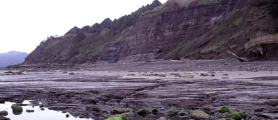
If you want to see what Seaside looks like underneath, head to Cannon Beach. He pointed to bedrock and cliffs with layers stretching across that tell all sorts of geologic tales, even providing this picture.
The end of the Ice Age meant a huge rise in sea levels around here, where the beaches were probably a few miles west from where they are now. Then, somewhere after 10,000 years ago, the ice melted and the seas rose, swallowing up old formations and random stuff they left behind, like gravel from creeks.
“Probably, those sediments at 125 below sea level include creek gravels laid down in streams before rising sea level flooded the coastal plain in this area, roughly 7000 years ago,” Horning said. “Under all these young sediments, it is good old mudstone of the Astoria Formation, what makes up the hills around Cannon Beach.”
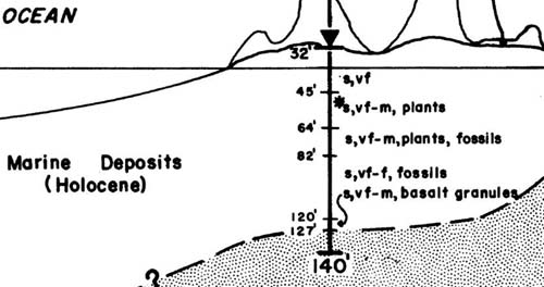
Horning provided a graphic spotlighting the Gearhart area, but it’s largely the same as Seaside. In it, you see layers of plants, fossils and crumbled bits of basalt.
The Astoria Formation is like the ground floor of most Oregon coast beaches. Not like most of the headlands such as Tillamook Head or Neahkahnie, which are made of basalt (former lava flows), the Astoria Formation is softer.
Sometime around 18 million years ago or so, a massive area along what would eventually become the northwest United States had already been carved out by various kinds of erosion. About then, it started filling back up with other rock debris, primarily sandstone and similar materials. It was all underwater or around the tideline, and it formed a layer of sandstone and mudstone that was eventually named the Astoria Formation, running from the central Oregon coast up to the north coast.
It's part of a massive underlying structure. This is softer stuff and gray, not black like basalt. It was actually a kind of fill-in mish mash of a variety of materials, much of it coming from eroded basalt from around Oregon, including the Gorge and other sources.
That’s what you’re walking when you see bedrock during the winter at Hug Point or Arch Cape. It’s the same stuff lying 150 feet below Seaside.
Lots of fossils are embedded in these mudstones and sandstones, which can be seen at Hug Point and especially Newport’s Moolack Beach in winter. When sand levels drop like this, it makes you a kind of time traveler. Seaside Hotels in these areas - Where to eat - Maps - Virtual Tours
Cannon Beach Lodging
Nehalem Bay Lodgings
Manzanita Hotels, Lodging
Three Capes Lodging
Pacific City Hotels, Lodging
Lincoln City Lodging
Depoe Bay Lodging
Newport Lodging
Waldport Lodging
Yachats Lodging
Oregon Coast Vacation Rentals
Oregon Coast Lodging Specials
More About Oregon Coast hotels, lodging.....
More About Oregon Coast Restaurants, Dining.....
LATEST Related Oregon Coast Articles
The building had also been robbed of pipes and copper by other thieves. True Crime, Astoria, Warrenton
Oregon Coast Crabbing Petition Denied, Rulemaking Process Remains on Course
A petition on procedural matters denied; no major changes yet. Whale
S. Oregon Coast Wind Warnings, Waves Up To 23 Feet
Gusts up to 65 and high waves for the weekend from Reedsport to Brookings. Weather
Newport Latest Oregon Coast Town to Ban Personal Fireworks Year-Round
City countcil voted this week; the pro fireworks display goes on as usual
Hazardous Seas Watch on N. Oregon Coast, S. Washington Coast, Waves Up To 15 Ft
Beaches will require caution but some good wave shows possible
Annual 'Maine' Event Returns to N. Oregon Coast's Seaside Aquarium
February 22 brings the fundraiser to Seaside. Seaside events
From Taking In Cool Oregon Coast Colors on the Patio to Seaside's Action
Review of Seaside's Seashore Inn on the Beach: spectacle with breakfast and your dog. Seaside hotel reviews
Oregon US Coast Guard Team Assists in Olympic National Forest Rescue
Helicopter team from Astoria rescued hikers on Washington's Mount Ellinor
Back to Oregon Coast
Contact Advertise on BeachConnection.net
All Content, unless otherwise attributed, copyright BeachConnection.net Unauthorized use or publication is not permitted


