Yachats Geology: Wonders and Frights of Central Oregon Coast
Published 04/14/2011
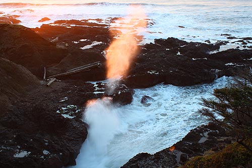
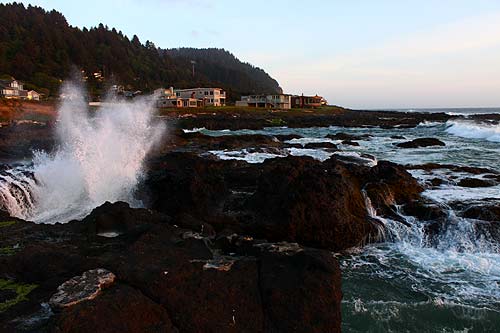
(Yachats, Oregon) – These days, Cape Perpetua and the dozens of stunning beach spots in this area and around Yachats are one awe-inspiring wonder after another. Black, basalt shorelines form abrupt barriers that cause the surf to continuously explode in dramatic fashion. High, soaring cliffs take us up above it all so we can gawk in more wonder. And funky formations allow more watery pyrotechnics that often startle you (above: Cook's Chasm).
All this, however, came about because of one kind of massive lava flow or another, sometimes underwater and sometimes from a towering volcano.
According to the Oregon Department of Geology and Mineral Industries, about 38 million years ago there was (and still is) a kind of soft spot in the Earth’s crust that allowed all sorts of enormous lava flows to erupt. At the same time, the tectonic plate that contained this area of the coast was far inland – it has since drifted 100’s of miles to its current location.
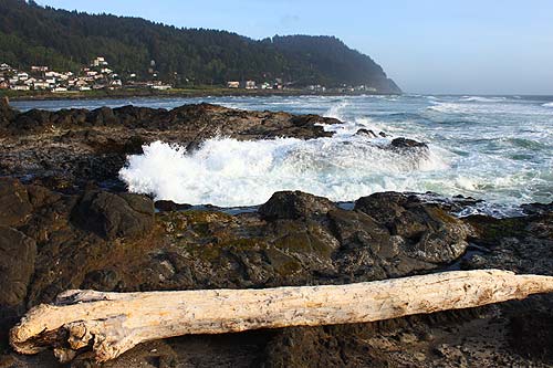
Yachats, with Cape Perpetua in the background
As this area of the continent drifted over that eruptive area, over a period of several million years it created some massive mountain structures and vast basalt areas – like Cape Perpetua and the basalt that makes up this part of the central Oregon coast. These hills are actually old volcanoes, and some of them were underwater.
Often, these local lava eruptions would explode with major force when they hit the water, creating interesting bubble-like shapes in the basalts. Other times, underwater eruptions created their own interesting shapes.
It seems Cape Perpetua was a massive volcano likely fueled by the soft spot (where Yellowstone exists now). Another theory has it that it there was another fault line around this area that funneled magma into the volcano, but petered out around 30 million years ago.
In either case, the volcano that is now Cape Perpetua - and other volcanic flows beneath the ocean and nearby - all happened right around here. Cascade Head near Lincoln City is also one of these from the same time period.
This is interesting because many basalt features along the coast come from what is called the Columbia Basalts, meaning massive eruptions around 300 miles away that created an ocean of lava that spread across prehistoric Oregon, creating the Columbia Gorge and many other features we see on the coast.
The old volcano now known as Cape Perpetua was apparently what is called a shield volcano, meaning the usual cone shape we see most of the time.
But the whole area’s history is more complex than that.
Some chunks of the area were formed by intrusive lava flows – lava so intense it more or less drills downwards into sediment and softer materials, only to re-emerge and re-erupt elsewhere (Cannon Beach’s Haystack Rock is a great example of this).
Not all these lava flows were equal strength, either, and thus the basalt rock they leave behind can be more susceptible to erosion. Some are incredibly dense because they’re pure, but others cooled with bits of rocks and boulders inside, which weakened them to some degree. Ironically, most of these rocks and boulders could’ve come from the very same lava flow. These are fragmented and contain “breccias,” which come about when lava spits up into the air and then cools into rock forms, or other situations like when the exterior of a lava flow cools and quickly creates chunks of basalt.Some of these somehow get mixed up with a moving lava flow that cools, and becomes fragmented and less able to resist the onslaught of the tides over the next several million years.
When these weak spots allow erosion and cracking from the waves, the tides eventually dig huge cracks and other formations into the basalt, like features such as Cook’s Chasm, the Devil’s Churn, or the many basalt platforms of random shape that proliferate this area.
Sometimes these weak spots get eroded into caves, like the Sea Lion Caves just north of Florence.
Then things get really complex around here – which shows in the diverse geography of this section of the Oregon coast. High basalt cliffs give way to a mix of sandy beaches and basalt structures, sometimes creating beaches with both that make for a kind of labyrinth of things to climb on, with stretches of sand in between.
Over these millions and millions of years, especially in the last two million or so, the land itself has risen and fallen, as the pushing of the tectonic plates created the Oregon coast range. Then, later the sea rose and fell as well, as the ice age caused the shoreline to move back and forth, sometimes by tens of miles.
As this happened, the sea cut terraces into the land. As it the sea receded or the land level fell, more sediment stuff filled up those areas. This has resulted in some areas becoming more dune-like, and others that have been rising are seeing the rocky beds and benches exposed.
There were even some sand dune areas up on Cape Perpetua at certain points in the dim and distant past, and one of these patches is where the visitor center is built upon.
Areas with more rocky stretches are often rising slowly, such as areas like Pacific City, other parts of the Three Capes Loop, and areas around Manzanita and Cannon Beach. Those sinking are becoming more dune-like, such as the 40 miles of the National Dunes Recreation Area just south of Florence.
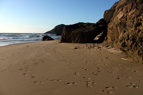
Bob Creek
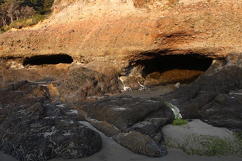
Strawberry Hill
More About Yachats Lodging.....
More About Waldport, Yachats Restaurants, Dining.....
LATEST Related Oregon Coast Articles
Likely just before dawn best hour but peak happens during daylight. Weather
Dark Sky Week is Prime Along Oregon Coast: Where and Where Not to Go
General guide to dark sky viewing from south to north coast. Astronomy
Sizable Price Drop, Deals in Lincoln City During Quiet of April on Central Or...
20 perc off at A1 Vacation Rentals across its roster, including Gleneden Beach. Lincoln City specials
Upcoming S. Oregon Coast Events Include Gem Show, History: Coos Bay, Bandon
May 6 talk at Coos History Museum, Mayfly Fest May 17, Bandon Rock / Gem Show June 7,8
Washington Coast Cleanup on April 19 - Coinciding with Oregon Coast's SOLVE E...
From the Puget Sound to Long Beach, alongside Oregon's cleanup. Washington coast events, Seaside events
Astoria's Riverwalk Gets New Lighting, More N. Oregon Coast Roadwork
Delays coming this summer, but the riverwalk has a new look. Seaside, Cannn Beach
April Gets Even Cheaper Midweek at Depoe Bay, Lincoln City: Oregon Coast Deals
Off-season rates plus more at Keystone Vacation Rentals. Depoe Bay lodging specials, Lincoln City hotel reviews, Newport hotel reviews
Washington Coast Begins Week of Clam Digs, April 12 Through 18
Long Beach, Twin Harbors, Mocrocks and Copalis at different times. Washington coast events
Back to Oregon Coast
Contact Advertise on BeachConnection.net
All Content, unless otherwise attributed, copyright BeachConnection.net Unauthorized use or publication is not permitted


