Hidden Beach on Central Oregon Coast Filled with Mysteries, Scientific Delights
Published 04/01/2011 at 5:41 a.m.
By Oregon Coast Beach Connection staff
Includes exclusive listings; some specials in winter
In Cannon Beach:
Includes rentals not listed anywhere else
In Manzanita, Wheeler, Rockaway Beach:
Some specials for winter
In Pacific City, Oceanside:
Some specials for winter
In Lincoln City:
Some specials for winter
In Depoe Bay, Gleneden Beach:
Some specials for winter
In Newport:
Look for some specials
In Waldport
Some specials for winter
In Yachats, Florence
Some specials for winter
Southern Oregon Coast Hotels / Lodgings
Reedsport to Brookings, places to stay; winter deals
(Newport, Oregon) – It's part adventure in a Lewis & Clark vein, part visual feast and part scientific exploration.
It's a very hidden beach lying just below the north face of Yaquina Head, really only accessible from a long walk from Moolack Beach, perhaps about a mile. There is a secret access from one of the neighborhoods at the edge of Yaquina Head, but this won’t be disclosed as locals won’t appreciate the intrusiveness of parked cars.
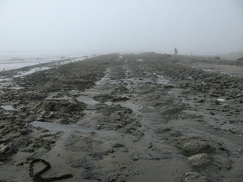
Here, the landscape abruptly changes from sandy to a strange rock formation you’re walking on, where things are poking out at odd angles.
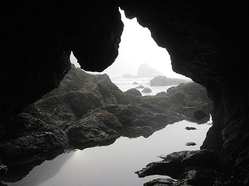
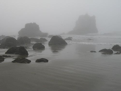
Then, all of a sudden, you’re face to face with the end of this trail of discovery, as the bottom of gigantic basalt Yaquina Head is facing you, along with a set of craggy sea stacks and some amazing tide pool life. It’s the coolest beach you’ll probably never see.
 Poke around just a bit and you’ll notice what looks like a big sea cave, but really it’s a sizable arch showing more curious wonders. Meanwhile, at your feet are a host of starfish colonies and other tide pool beasties that will delight you for hours.
The cliffs here have strange and abrupt diagonal lines in them, giving the impression some massive geologic cataclysm occurred here.
It could well have. But certainly the events that created this magnificent and memorable place are massive, like the volcano that created Yaquina Head, or the fact you’re standing on a place that was underwater until only fairly recently – in geologic terms.
 There is a fascinating document written in 1971 as a visitors guide to geology of the area that explains much about this engaging spot. It was written by Parke D. Snavely, Jr. and Norman S. Macleod back then for the State of Oregon Department of Geology and Mineral Industries. Snavely passed away in 2003 and has a USGS research vessel now named after him.
“The sedimentary and volcanic rocks exposed in the coastal strip between Yaquina Head and Government Point record an eventful geologic history - a history of uplift and erosion, of fluctuating shorelines, eruption of lava from several volcanoes, and the dislocation of rock units by faults,” the document begins. So you know you’re in for a trippy ride through time and the geology of this part of the central Oregon coast.
If this place could speak, it would freak you out. And it has spoken, at least to regional geologists.
At the bottom of everything – and out of site – is a bedrock called the Yaquina Formation, which was created some 25 to 22 million years ago. It’s mostly sandstone and siltstone, with some volcanic rocks thrown in. Those rocks are similar to those of the Cascade Range. Parts of this formation apparently can be seen within the city limits of Newport, though geologists haven’t indicated where, and it could well be these are now covered up by buildings and streets.
Around 22 million years ago, forces beneath the crust here started warping the ocean bed downwards, and other materials eventually filled in this void.
This is called the Nye Mudstone and can be seen exposed along the northern part of Yaquina Bay, showing as olive-gray mudstone and siltstone, which weather into colors like a rusty brown. Fish scales and other tiny bits of fossils have been found here.
Around 18 to 20 millions years ago, according to these Oregon coast geology documents, there were periods where this undersea formation was lifted up and then eroded, and after that sandstone materials were deposited – a layer now called the Astoria Formation, which shows up as landmarks like Jump-Off Joe and many of the sea cliffs from Nye Beach, through Moolack Beach and Beverly Beach, up to the Devil’s Punchbowl. It’s yellow and gray, and sometimes a dark gray, depending on what’s mixed in.
Larger fossils have been found in these layers, including a kind of prehistoric hippopotamus and ancient sea lions. Some of these fossils were collected as far north as Geleneden Beach and have been on display at the Smithsonian.
 This Astoria Formation comprises the rockbeds you see poking up out of the sand, the stuff that often makes up the cliffs of the area, and the rocky slabs and rockbeds that are titled at odd angles at this secret spot.
These beds are made of sandstone, siltstone and volcanic ash, and these features are sometimes described as like “ribs” of rock in the sand.
The Oregon state geology document says these were originally flat, but were later tilted by geologic forces that deformed the area – and although it doesn’t exactly describe how it seems to have something to do with faults.
“Small faults that offset beds a few inches to a few feet can be observed on these beach exposures,” the documents says.
You can see this most dramatically in the diagonal lines in the cliffs immediately next to the bottom of the headland.
Yaquina Head itself is from the Columbia Basalts - the massive eruption some 14 million years ago that created landmarks like Cannon Beach's Haystack Rock, Tillamook Head, Cape Meares, Neahkahnie Mountain and even Seal Rock. Yaquina Head has been eroded heavily by sea and sand over time, and it’s full of many different kinds of deposits. There’s a local rumor the headland has large veins of iron running through it, enough that the landmark supposedly screws up compasses of passing ships. But this is apparently just a rumor.
The Newport office of Oregon’s geology department has rather sizable evidence that Yaquina Head was once covered by an enormous sand dune. Somewhere around 4,000 years ago, sands shifted for whatever reason and covered up the area, according to Roger Hart of the Newport office, in an interview with Oregon Coast Beach Connection in 2007.
Hart passed away in 2011.
They’ve discovered shell middens dating almost that far back. That and other finds are leading experts to believe native tribes people walked down a fairly gradual slope to the shore to collect shellfish.
If you’re going to visit this place, make sure you do so at a fairly low tide and during calm conditions. It is a short beach with a high cliff wall all along its length, so it can be very dangerous if waves are coming up close to them. Also, the basalt bottom of the headland may not even be accessible at anything but a substantially low tide.
Hotels in Newport - Where to eat - Newport Maps and Virtual Tours
Cannon Beach Lodging
Nehalem Bay Lodgings
Manzanita Hotels, Lodging
Three Capes Lodging
Pacific City Hotels, Lodging
Lincoln City Lodging
Depoe Bay Lodging
Newport Lodging
Waldport Lodging
Yachats Lodging
Oregon Coast Vacation Rentals
Oregon Coast Lodging Specials
More About Oregon Coast hotels, lodging.....
More About Oregon Coast Restaurants, Dining.....
 Andre' GW Hagestedt is editor, owner and primary photographer / videographer of Oregon Coast Beach Connection, an online publication that sees over 1 million pageviews per month. He is also author of several books about the coast.
LATEST Related Oregon Coast Articles
Likely just before dawn best hour but peak happens during daylight. Weather
Dark Sky Week is Prime Along Oregon Coast: Where and Where Not to Go
General guide to dark sky viewing from south to north coast. Astronomy
Sizable Price Drop, Deals in Lincoln City During Quiet of April on Central Or...
20 perc off at A1 Vacation Rentals across its roster, including Gleneden Beach. Lincoln City specials
Upcoming S. Oregon Coast Events Include Gem Show, History: Coos Bay, Bandon
May 6 talk at Coos History Museum, Mayfly Fest May 17, Bandon Rock / Gem Show June 7,8
Washington Coast Cleanup on April 19 - Coinciding with Oregon Coast's SOLVE E...
From the Puget Sound to Long Beach, alongside Oregon's cleanup. Washington coast events, Seaside events
Astoria's Riverwalk Gets New Lighting, More N. Oregon Coast Roadwork
Delays coming this summer, but the riverwalk has a new look. Seaside, Cannn Beach
April Gets Even Cheaper Midweek at Depoe Bay, Lincoln City: Oregon Coast Deals
Off-season rates plus more at Keystone Vacation Rentals. Depoe Bay lodging specials, Lincoln City hotel reviews, Newport hotel reviews
Washington Coast Begins Week of Clam Digs, April 12 Through 18
Long Beach, Twin Harbors, Mocrocks and Copalis at different times. Washington coast events
Back to Oregon Coast
Contact Advertise on Oregon Coast Beach Connection
All Content, unless otherwise attributed, copyright Oregon Coast Beach Connection. Unauthorized use or publication is not permitted


