Oregon Coast History: Life Before Highway 101, When Beaches Were Roads
Published 11/26/2012

(Oregon Coast) - You probably haven't stopped to think about it, but there was a time when Highway 101 didn't exist along the Oregon coast. What did early Oregon settlers do to get from one coastal town to another? (Above: the road going around Hug Point, near Cannon Beach)
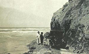 |
| Hug Point in the past |
Also, we don't always know how lucky we have it here in Oregon, with pristine beaches open to everyone (unlike most other coastal states, where the good beaches - that aren't private - all charge a admission fee.)
These two situations are connected.
Before the 30's, all that settlers of this area had for public roads were the beaches (evidence of which can still be seen at the road carved out of the rock at Hug Point, just south of Cannon Beach.) In 1914, Governor Oswald West declared the beaches public highways, and construction on what was to become Highway 101 began shortly after. The Columbia Highway was to run from Seaside to Astoria and then along the Columbia River to Pendleton. The Oregon Beach Highway was to run from Seaside down to the California line.
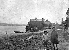 |
| Newport's bayfront and its muddy road, about 100 years ago. |
Travel up and down the coast was rustic and difficult to say the least. What now takes around a half hour once took two days. In 1912, a group of men called the “Pathfinders” took a two-day journey by car from Newport to Lincoln City – which was a landmark adventure then. They had to create their own roads via planks at times.
In 1915, an unpaved highway between Astoria and Portland opened up. And after several name changes, Highway 101 was paved and finished in 1931. Then, and only then, could coastal towns connect with each other. According to some state documents, Oregonians at the time discovered incredibly different cultures had evolved in each coastal town, the result of decades of isolation from each other and the rest of the state.
After West's declaration that beaches were to be public, several laws were passed giving the Highway Commission more control over the beaches over the years. The Oregon State Parks system was an offshoot of this legislation, starting under the highway department in 1925. All this helped pave the way for Gov. Tom McCall to finalize Oregon's beaches as public in the 60's.
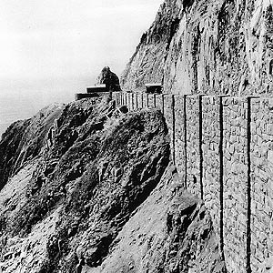 |
| Neahkanie Mountain in its old days |
There is little evidence left of these beach highways now, except at Hug Point. But plenty of historical photos of the Oregon coast show lots of ruddy, muddy roads wbere vehicles became stuck. Newport itself was divided up into Nye Beach and the bayfront – two different towns at the time. These were connected by just such roads.
One interesting bit of evidence discovered in recent years was the remains of a mail truck from around 1920 that was uncovered by low beach sands around Waldport.
Aside from that, there's no hint that the ten-minute drive you now take – from, say Yachats to Newport, or Oceanside to Netarts – took days back then. A few of the overlooks around the coast are from that period of New Deal work projects, like at Cape Perpetua or Manzanita's Neahkahnie Mountain. But by and large, you have to stare down at the beach and use your imagination.
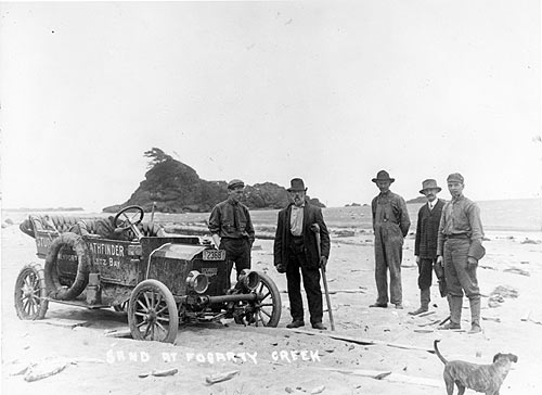
Above: Newport beaches as roads: the Pathfinder group in 1912 slowly making it to Lincoln City. Here they're getting stuck at Fogarty Beach near Depoe Bay. Photo courtesy Lincoln County Historical Society.
More About Oregon Coast hotels, lodging.....
More About Oregon Coast Restaurants, Dining.....
LATEST Related Oregon Coast Articles
One was a rare orca find; both suspected human interaction. Marine sciences
N. Oregon Coast's 'Cheese War' a Quiet Part of Tillamook-Area History: See th...
History talk in Nehalem on April 26 about Tillamook battles. Manzanita events, Cannon Beach events, Tillamook events
Lyrid Meteors with a Possible Side of Aurora for Washington, Oregon, Coastlines
Lyrids peak on Monday, northern lights possible northern Washington. Weather
Road Work Coming to North Oregon Coast's Gearhart and One of World's Largest ...
Lane closures this summer on the bridge; major work in Gearhart next year. Washington coast
Be Jeweled Returns to Central Oregon Coast, Newport's Dazzling, Arty Jewelry ...
Saturday, May 10, from 10 AM to 4 PM featuring more than 2,000 pieces. Newport events
N. Oregon Coast Bridge Work During Travel Season: Some Traffic Delays on Asto...
Occasional one-lane traffic from June through September at Astoria / Ilwaco. Washington coast
Cape Kiwanda's Colossal Sand Dune: Wild Oregon Coast Rides and How It's Changing
A mix of crazy recreation with science of a crumbling landmark. Sciences, Pacific City, Oceanside
Oregon Coast, Valley and Likely Washington Coast to Get Some Aurora Borealis ...
Likely just before dawn best hour but peak happens during daylight. Weather
Back to Oregon Coast
Contact Advertise on BeachConnection.net
All Content, unless otherwise attributed, copyright BeachConnection.net Unauthorized use or publication is not permitted


