Integral S. Oregon Coast Roadway Finally Under Reconstruction: Near Shore Acres
Published 01/28/25 at 6:06 a.m.
By Oregon Coast Beach Connection Staff
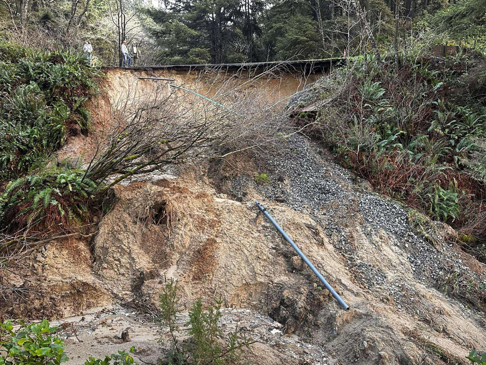
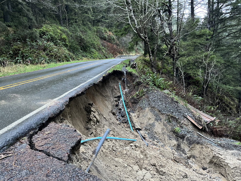
(Coos Bay, Oregon) – Oregon State Parks and Recreation Department (OPRD) announced that reconstruction work on Cape Arago Highway has begun, after a landslide took out an integral part of the roadway on January 3. The route to Cape Arago and extremely popular Shore Acres State Park has been closed the entire time. (Photo Oregon's Adventure Coast)
Includes exclusive listings; some specials in winter
In Cannon Beach:
Includes rentals not listed anywhere else
In Manzanita, Wheeler, Rockaway Beach:
Some specials for winter
In Pacific City, Oceanside:
Some specials for winter
In Lincoln City:
Some specials for winter
In Depoe Bay, Gleneden Beach:
Some specials for winter
In Newport:
Look for some specials
In Waldport
Some specials for winter
In Yachats, Florence
Some specials for winter
Southern Oregon Coast Hotels / Lodgings
Reedsport to Brookings, places to stay; winter deals
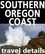
It's an important part of the year for tourism at Shore Acres, as it displays the largest wave action on the entire Oregon coast.
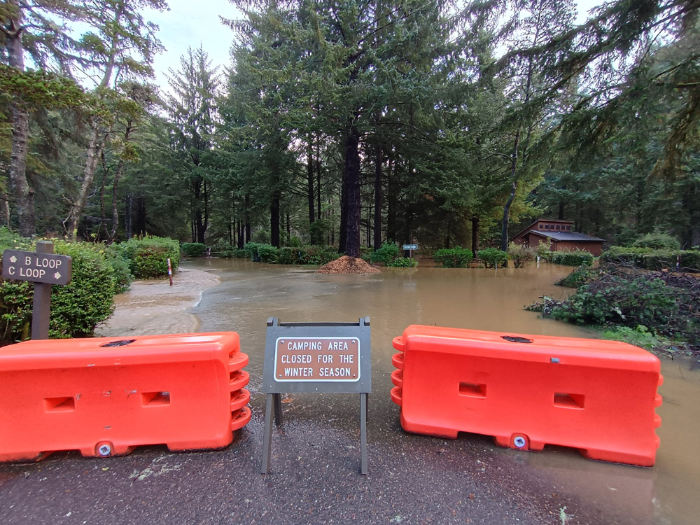
Meanwhile, Sunset Bay and its campgrounds reopened shortly after they flooded on January 3.
Many of the hiking trails have been open during all this, including one where you could get to Shore Acres. However, that will be cut off for a time as well.
“The road will be closed to all vehicle, bike, and foot traffic,” OPRD said. “Visitors will still be able to access the Bog Trail between the campground and Yoakam Point, the day-use areas of Sunset Bay, and the portion of the Oregon Coast Trail (OCT) that goes from South Sunset Bay Day Use to Norton Gulch. There will not be access to any trails south of Norton Gulch while construction is happening. Shore Acres and Cape Arago State Parks will be inaccessible during this time.”
That part of the highway at Northon Gulch has been problematic in the past, and this time the damage was overwhelming. OPRD said the construction is expected to last several weeks – although no specific date for reopening was given. That will be announced as soon as contractors have a clearer idea of when.
Oregon State Parks
Contractors have to rebuild as well as repair the infrastructure. Beyond the scope of the project, construction is “extremely weather dependent,” OPRD said. Work can be very on-and-off this time of year because of heavy rains and winds.
Janice Langlinais, executive director of Oregon's Adventure Coast, said the entire roadbed in the area has to be rebuilt, needing complete reconstruction.
Langlinais told Oregon Coast Beach Connection that although hikers cannot currently get to Shore Acres or Cape Arago because of the roadwork, there are many other possibilities for a wonder-filled hiking experience.
Oregon State Parks: when Sunset Bay first flooded
“The hike from Sunset Bay day use to the point where the trail is blocked for the roadwork offers a variety of opportunities to see the ocean, walk through the coastal forest, and spy the lighthouse,” she said.
See Landslide Shuts Down Access to S. Oregon Coast's Shore Acres, Flooding at Sunset Bay
There are also trails from the Oregon Dunes National Recreation Area, which include the John Dellenback Trail, the only non-motorized portion of the dunes.
“Or another option is going inland from Coos Bay about 25 miles to Golden and Silver Falls State Natural Area,” Langlinais said. “These two waterfalls have been flowing quite well this winter due to the rain from earlier in the month. These are easy hikes to the bases of both waterfalls with a slightly more strenuous hike to the top of Golden Falls. Also note that this Silver Falls is not to be confused with the falls near Silverton, Oregon.”
There is more on this part of the south Oregon coast's hiking opportunities at https://www.oregonsadventurecoast.com/hiking-walking/
Oregon Coast Hotels in this area - South Coast Hotels - Oregon Coast Vacation Rentals - Where to eat - Maps - Virtual Tours


Oregon Coast Vacation Rentals
Oregon Coast Lodging Specials


Silver Falls near Coos Bay. Photo Oregon's Adventure Coast
More About Oregon Coast hotels, lodging.....
More About Oregon Coast Restaurants, Dining.....


 Andre' GW Hagestedt is editor, owner and primary photographer / videographer of Oregon Coast Beach Connection, an online publication that sees over 1 million pageviews per month. He is also author of several books about the coast.
LATEST Related Oregon Coast Articles
CME Heads for Earth, Possible Aurora Borealis Monday Night for Oregon, Washin...Weather good for most of Oregon. You'll need a camera to see. Astronomy
Man Drowns at Central Oregon Coast's Thor's Well, Near Yachats
The man fell into the infamously dangerous watery hole and died. Safety, weather
Florence Opens Photo Contest: $250 Prize for Best Central Oregon Coast Snap
Inviting amateur and professional photographers. Florence events
Time-lapse of North Oregon Coast: Witness Changes at Cannon Beach, Seaside, M...
Seeing things shift and change at Wheeler, Neahkahnie, Oswald West, Seaside, Cannon Beach
Another Side to Coos Bay's Shore Acres: Oregon Coast Waves of Color at a Lavi...
For 100 years now, Shore Acres Garden has created a quiet spectacle
Burst of Cranberry Colors, Food, Fun on S. Oregon Coast as Bandon Celebrates ...
79th Annual Bandon Cranberry Festival recognizes farming through education, entertainment and fun. Bandon events
US Coast Guard Forced to Suspend Search for Men Off South Oregon Coast, Missi...
Cold temperatures and having been missing all night ended the search. Safety
US Coast Guard Halts Search for Missing Fisherman Off Central Oregon Coast
The vessel capsized near Newport's Yaquina Bay Jetty over the weekend. Weather
Back to Oregon Coast
Contact Advertise on Oregon Coast Beach Connection
All Content, unless otherwise attributed, copyright © Oregon Coast Beach Connection. Unauthorized use or publication is not permitted

Oregon
Coast Hotels
S. Coast Hotels
Astoria/Warrenton Hotels
Seaside Hotels
Cannon
Beach Hotels
Nehalem Bay Lodgings
Manzanita Hotels, Lodging
Rockaway Beach Hotels
Three Capes Lodging
Pacific City Hotels, Lodging
Lincoln
City Lodging
Depoe
Bay Hotels
Newport Hotels
Waldport Lodging
Yachats
Hotels
Florence Hotels
Reedsport Hotels
Coos Bay Hotels
Bandon Hotels
Port Orford Hotels
Gold Beach Hotels
Brookings Hotels
Oregon
Coast Vacation Rentals
Oregon
Coast Lodging Specials
South Coast Hotels
Dining
Guide
Seaside
Cannon
Beach Dining
Manzanita,
Rockaway, Wheeler Dining
Pacific
City, Oceanside, Netarts, Tierra Del Mar Restaurants
Tillamook
Bay Restaurants, Dining
Lincoln
City Dining, Restaurants
Depoe
Bay Restaurants, Dining
Newport Restaurants, Dining
Waldport,
Yachats Restaurants, Dining
Florence Restaurants, Dining
Restaurant
Reviews
Coast
Events Calendar
Astoria
Seaside,
Cannon Beach Calendar
Manzanita,
Rockaway Events
Tillamook,
Pacific City Calendar
Lincoln
City Events Calendar
Newport,
Depoe Bay Events Calendar
Yachats Events Calendar
Oregon Coast Complete Guides every beach access, attraction
Search for Oregon Coast Subjects, Articles
Explore Every Beach Spot


News Headlines from All Over Oregon Need to scan Oregon headlines? Constantly updated news from all over Oregon: a comprehensive, up-to-the-minute display of news headlines from a variety of media
Oregon Coast Oceanfront Lodging, Hotels, Rentals