How Much of the N. Oregon Coast Did Not Exist 100 Years Ago? It's Amazing
Published 06/29/2016 at 7:51 PM PDT - Updated 06/29/2016 at 7:59 PM PDT
By Oregon Coast Beach Connection staff
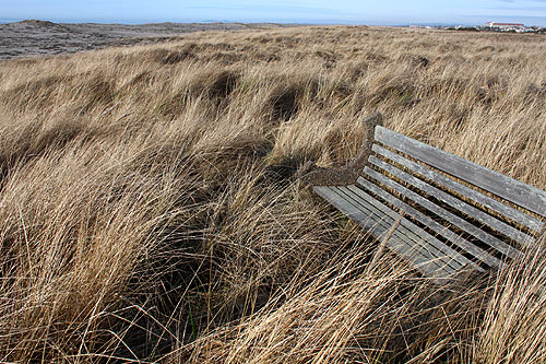
(Warrenton, Oregon) – Mankind has changed the beaches of the north Oregon coast in some astounding ways. Literally miles and miles of it did not exist a little over 100 years ago, until humans starting building jetties at the baymouths so that less lives would be lost due to shipwrecks. (Above: these dunes did not exist 100 years ago in Gearhart, and this bench would be in the surfline).
Seaside and Gearhart would be much shorter now. Enormous tracts of Fort Stevens State Park would not be there. On the other hand, a lot of invasive plant species might not be around and large sections of grazing lands would still be there for cattle and horses.
It's had its pluses and minuses. In any case, the building of the jetties at the Columbia River have had some impacts so large they're hard to fathom.
Building jetties greatly increases the rate that sand flows and gets deposted. Frequently, it moves more and more into surrounding areas, which can ironically cause erosion in other places. But in the case of the Columbia River, building the jetties there - which started in the 1890's and ended by the '20s - shifted the sands in whole new ways.
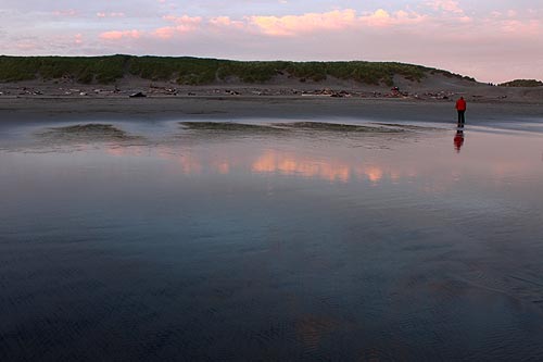
Fort Stevens State Park Grew in a Big Way. Did you know that parts of Fort Stevens didn't exist before the jetties? The building of jetties at the mouth of the Columbia in the 1890's allowed a mindbogglingly large chunk of land to be created. Many of the ponds and wetlands you see along the road going to the south Jetty weren't there when Lewis & Clark wandered these shores.
According to one lidar map, something like a half mile of shoreline around the western side of Fort Stevens was not there until after the building of the jetties.
North Oregon coast geologist Tom Horning said the changes happened quite quickly. Within a few years a good deal of sand and land were added to the area.
Studies done by Oregon State University geologists have found that while so much has been lobbed onto the area by the changes in sediment and sand distribution, these areas are very vulnerable to erosion. Peter Ruggiero, an assistant professor of geosciences at OSU, wrote a paper several years ago that showed all these newly-created sections of shoreline are still not yet stable. Nature has not figured out if it's taking sand away or depositing more.
Beaches to the north and south have been affected to large degrees. Ruggiero has said that parts of the southern Washington coast may be more vulnerable to disappearing than farther south.
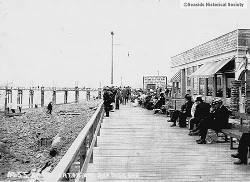
Seaside 100 years ago
Seaside and Gearhart Changes. One of those major affected areas is as far south as Gearhart and Seaside. All that extra sand drastically altered Seaside in the '20s, extending the shoreline a few hundred feet or more. Before that, old historical photos show a rockier beach with a steeper slope, allowing the existence of a wooden pier for some time.
Those old timey photos show a shoreline less than 100 feet from what was then a wooden Promenade. Now, there's a few hundred feet of dunes and soft sands to deal with. In fact, the city bulldozes away a layer or two every year, as the dunes keep growing.
What would Seaside look like if no one did that? Just look at Gearhart. Horning said the shoreline used to be much closer to where the westernmost homes are now. Since the jetties were built, all those huge dunes and that eight-of-a-mile-long walk to the beach weren't there before.
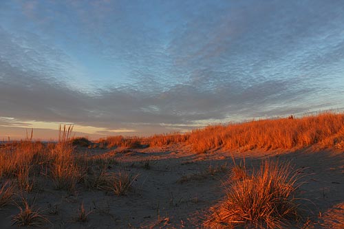
Seaside today
Dune growth rates more than doubled after the turn of the century. Soon, according to Horning, dunes each year grew by around 35 feet and up to three feet vertically.
“Since the jetties were built on the Columbia, the dune complex has grown westward as much as 2000 feet in places and to heights of as much as 45 feet,” Horning told Oregon Coast Beach Connection in 2010.
The area from Gearhart northward was known as the Clatsop Plains. When more sand began to deposit so quickly and heavily southward, a lot of it was blown inland. These created a “march” of the dunes eastward, and with it more beach grass. Add to that the introduction of invasive plant species like Scotch Broom in attempts to stabilize those dunes about 100 years ago, and you have a series of self-perpetuating cycles that resulted in a lot of grazing land getting beached out of existence. Horning said hundreds of yards inland were changed.
The tide, it seems, has begun to turn on the dunes, however. The growth rate has slowed in recent decades, down to expanding about 12 to 16 feet per year. Storms in recent years have cut away at the dunes quite dramatically, sometimes clipping them as much as 75 feet. Erosion is increasing in spots along the entire Oregon coast, including here, and that’s taking its toll on the dunes.
Oregon Coast Hotels in these areas - Where to eat - Maps - Virtual Tours
Below: 100 years ago much of Seaside looked more like the Cove area at its southern end
More About Oregon Coast hotels, lodging.....
More About Oregon Coast Restaurants, Dining.....
Cannon Beach Lodging
Nehalem Bay Lodgings
Manzanita Hotels, Lodging
Three Capes Lodging
Pacific City Hotels, Lodging
Lincoln City Lodging
Depoe Bay Lodging
Newport Lodging
Waldport Lodging
Yachats Lodging
Oregon Coast Vacation Rentals
Oregon Coast Lodging Specials
LATEST Related Oregon Coast Articles
Temps near freezing tonight, then weekend soars into 60s on beach, 70s inland. Weather
Registration Begins for SOLVE Oregon and Coastal Cleanup, April 12 - 22
Help clean coastal beaches, inland natural areas and cities. south coast events, Florence events, Astoria events, Seaside events, Cannon Beach events, Manzanita events, Rockaway Beach events, Tillamook events, Garibaldi events, Oceanside events, Pacific City events, Lincoln City events, Depoe Bay events, Newport events, Waldport events, Newport events, Yachats events
Volunteers Needed for Garden Near Coos Bay: Help Out Oregon Coast Landmark at...
Inviting everyone to roll up their sleeves and join its Garden Volunteer Days. Coos Bay events, south coast events
April 3 is Cape Lookout Stewardship Day on N. Oregon Coast: How You Can Help
Inviting volunteers to care for natural spaces and restore landscapes. Oceanside events
Cape Arago Highway Reopens, S. Oregon Coast Landmarks Like Shore Acres Access...
Shut down for a month, surprise announcement on the Coos Bay-area road
Small Travel Impact from Snow in Oregon Coast Range Over Weekend - Portland G...
Brief, minor snow issues in Coast Range as Portland dries up
More Snow for Oregon Coast Range - Portland, Vancouver, Salem Get Colder Late...
Snow levels drop, chance of dusting on beaches, freeze warning south coast
Snowy Hazards in Oregon Coast Range as Portland, Eugene, SW Washington Get Du...
Winter storm warning in coast range; snow levels down to 500 feet. Weather
Back to Oregon Coast
Contact Advertise on BeachConnection.net
All Content, unless otherwise attributed, copyright BeachConnection.net Unauthorized use or publication is not permitted


