 |
 |


Lovely Oregon Coast Sights Have Frightening Beginnings
Published 2008
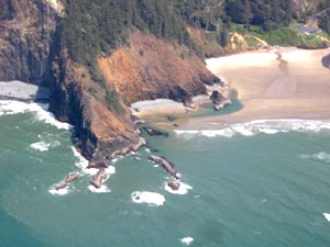 |
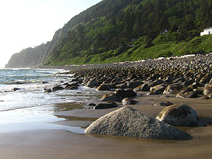
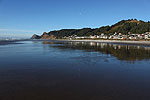
| The southern end of Indian Beach, part of Tillamook Head, has its origins in a massive lava flow some 15 million years ago. |
(Oregon Coast) - The origin of much of what you see on the Oregon coast began maybe 45 million years ago. The reason this area is so engaging - with its mix of sandy stretches, sandstone structures and then tall, basaltic cliffs of black with sheer drops to the ocean – has much to do with how things slowly got burned into existence, with erosion then playing a sizable part.
Hollywood movies couldn't come up with a more scary film idea. It's another case of true science being way stranger than fiction. Oregon coast geology could be a horror movie.
About 45 millions years ago, the coastline was actually some 70 to 100 miles inland – theorized to be about where Silver Creek Falls is right now. Tectonic plate movement over time, along with an element of rising and falling ocean levels, brings us to the location of the Oregon coast these days.
Then things got really nasty, and some really terrifying geologic events played a major role in what we now see.
 |
| The basalts of Depoe Bay were the result of lava flows of this period |
Picture this: a massive river of lava erupts in Idaho, so big it covers miles at a time as it marches along at around four mph. It sears entire forests into ashes and fumes. It builds gigantic damns of molten rock that are perhaps miles long, sometime bulging up to 20 feet high. It tromps its way through riverbeds and canyons, snaking its way around mountains, until it slithers its sinister, scorching heat into the ocean – having traveled some 300 miles, about seven days later. It’s hundreds of miles long, spewing out continuously and fiercely so that when it reaches the ocean it fills crevices and muddy areas thousands of feet deep.
This was the scene in Oregon some 15 million years ago, and it was the beginning of the birth of many of the incredible structures and tourist attractions you now see on the scenic Oregon coast. A colossal fissure in the Earth around where Lewiston, Idaho is now poured these horrendous flows into this area. It’s the same hot spot that now powers Yellowstone National Park, and has before created the mega-disastrous super volcanoes that have erupted a few times over the millennia.
 |
| Cape Foulweather, which towers over the sea, came from an eruption hundreds of miles long |
The coast at that time was about 15 miles farther inland than it is now. According to Seaside geologist Tom Horning, sometimes these lava flows poured into the ocean and then they spread out through the soft marine sediments for dozens of miles, burrowing into the layers. They then managed to come back up elsewhere, re-erupting through thousands of feet of muck, onto the sea floor, essentially making their own eruptions for a brief time (geologically speaking).
They then cooled to become solid basalt. Over millions of years, some of these massive invasions of lava were lifted with the sediments above sea level with the rising of the coast range. They in turn were eroded away, until they formed headlands and features we now know as Neahkahnie Mountain near Manzanita or Tillamook Head between Seaside and Cannon Beach.
 |
| Cape Lookout, the long, shadowy figure in the distance, is seen from Oceanside |
Another kind of lava flow that formed the headlands we know and love is called intra-canyon flows. These kinds of flows snaked their way to the coast through riverbeds and around other land features, arriving at the coast to build up and up out of deltas of rubbly submarine pillow basalt. These were then capped by sheets of dry-land lava flows.
Meanwhile, the ocean levels rose and fell around the landmasses and basalt shapes a few times. They too were eroded by time and water into shapes we now know as Cape Foulweather, Cape Lookout, Yaquina Head and Cape Meares.
Numerous such lava flows (perhaps around 300) erupted from about 12 million years ago to 17 million years ago, according Horning. They happened approximately every 100,000 to 200,000 years, creating their own kind of havoc, but in turn laying the groundwork (pun intended) for the beauty we now see.
 |
| Neahkahnie Mountain, overlooking Manzanita, was a laval flow that got lifted up and down several times over millions of years |
Meanwhile, millions of years earlier, Cascade Head was its own volcano, said Horning of the large, looming headland just north of Lincoln City. And what about those mini-eruptions that happened just offshore? Horning said they’re often responsible for many of the coast’s most famous landmarks.
“Haystack Rock in Cannon Beach was one of those,” Horning said. “Sea stacks are often from submarine feeders for the re-erupting lavas. They’re all part of plumbing systems.”
Erosion also plays a major part in what you see with that famous structure (which is currently the third highest sea stack in the world), along with the oceans rising, falling and the land doing the same.
“The basalt that Haystack Rock is made of is about 15 million years old,” Horning said. “It was an enormous hill of rock until about 3000 years ago, when rising sea levels allowed the surf to wash away all but the strongest lava/basalt. Some 4000 to 5000 feet of the original submarine volcano is missing from it now, having been eroded for more than 12 million years.”
Everybody's favorite Oregon coast icon, Haystack Rock, was one of those oddball invasive flows, where parts of one lava flow shot back down deep into the earth, then re-erupted elsewhere. It's basically a little eruption, born of a bigger one.
More About Oregon Coast hotels, lodging.....
More About Oregon Coast Restaurants, Dining.....
 |
|
 |

 |
 |
 |
 |
 |
 |
LATEST OREGON COAST NEWS STORIES
Washington Coast Cleanup on April 19 - Coinciding with Oregon Coast's SOLVE E... |
Back to Oregon Coast
Contact Advertise on BeachConnection.net


Secrets of the Season |

Unusual Travel Articles TravelParanormal.com allows you to submit your own creepy tale or debunk one - or see up-to-the-minute news headlines about travel and the paranormal. News Headlines from All Over Oregon Need to scan Oregon headlines? Constantly updated news from all over Oregon: a comprehensive, up-to-the-minute display of news headlines from a variety of media |
