NASA Will Examine Oregon Coast, Pacific Ocean More Closely from Space
Published 10/20/2015 at 6:22 PM PDT
By Oregon Coast Beach Connection staff
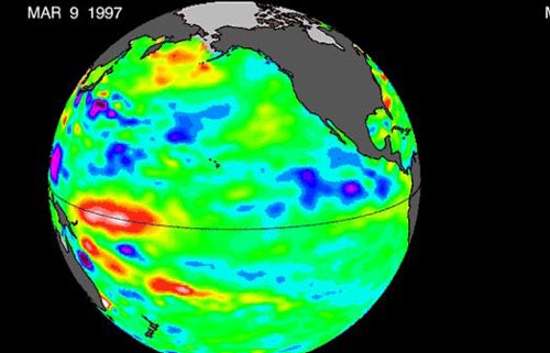
(Manzanita, Oregon) – As a powerful El Nino pattern is gearing up in the Pacific Ocean, NASA will be taking a much closer look at this unusually warm pool of water off the western U.S., which includes the Oregon coast. (Above: NASA climate modeling graphic of El Nino in '97).
Scientists at the World Meteorological Organization say this El Nino is predicted to be the strongest since that of 1997-98, which caused all sorts of meteorological anomalies around the world, including stronger storms along the Oregon coast. With that in mind, NASA plans to train the eyes of 19 satellites onto the Pacific, examining the weather patterns that emerge from that aquatic environment.
El Nino patterns happen every two to seven years, raising ocean temperatures two to three degrees Celsius higher than normal. Their impact can be worldwide, from droughts or flooding in California, Oregon and even Australia.
“El Niño is a fascinating phenomenon because it has such far-reaching and diverse impacts,” said Lesley Ott, research meteorologist at NASA’s Goddard Space Flight Center, Greenbelt, Maryland. “The fact that fires in Indonesia are linked with circulation patterns that influence rainfall over the United States shows how complex and interconnected the Earth system is.”
 NASA's satellite observations will be paired with supercomputer processing power for modeling systems, giving scientists a comprehensive suite of tools to analyze El Niño events and their global impacts.
The connections between global weather patterns affected by El Nino are complex – and they area wide-ranging. One area scientists will be looking at is how El Nino can change the fire seasons in the western U.S., Amazon and Indonesia. It's believed El Nino can also affect the yearly variability of ozone that comes up from the surface.
Other areas the satellites will be eyeing include the eastern Pacific Ocean, where warmer waters can help spur on disasters like floods and fires. The spacecrafts will be tracking storms, cloud cover and other patterns caused by this area's warmer ocean, which can have devastating effects on fisheries and other industries.
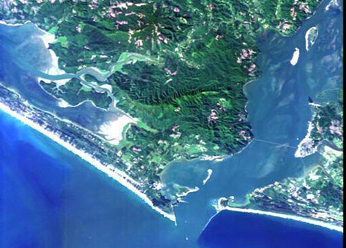
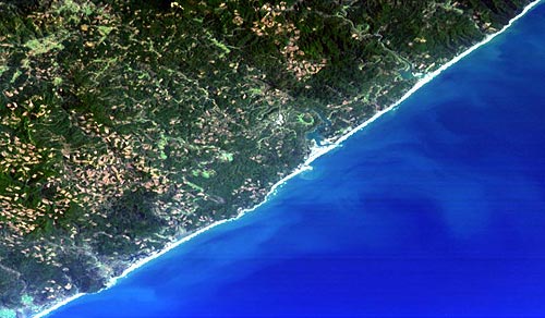
Below: Astoria and Newport, on the Oregon coast, as seen from space.
More About Oregon Coast hotels, lodging.....
More About Oregon Coast Restaurants, Dining.....
LATEST Related Oregon Coast Articles
Likely just before dawn best hour but peak happens during daylight. Weather
Dark Sky Week is Prime Along Oregon Coast: Where and Where Not to Go
General guide to dark sky viewing from south to north coast. Astronomy
Sizable Price Drop, Deals in Lincoln City During Quiet of April on Central Or...
20 perc off at A1 Vacation Rentals across its roster, including Gleneden Beach. Lincoln City specials
Upcoming S. Oregon Coast Events Include Gem Show, History: Coos Bay, Bandon
May 6 talk at Coos History Museum, Mayfly Fest May 17, Bandon Rock / Gem Show June 7,8
Washington Coast Cleanup on April 19 - Coinciding with Oregon Coast's SOLVE E...
From the Puget Sound to Long Beach, alongside Oregon's cleanup. Washington coast events, Seaside events
Astoria's Riverwalk Gets New Lighting, More N. Oregon Coast Roadwork
Delays coming this summer, but the riverwalk has a new look. Seaside, Cannn Beach
April Gets Even Cheaper Midweek at Depoe Bay, Lincoln City: Oregon Coast Deals
Off-season rates plus more at Keystone Vacation Rentals. Depoe Bay lodging specials, Lincoln City hotel reviews, Newport hotel reviews
Washington Coast Begins Week of Clam Digs, April 12 Through 18
Long Beach, Twin Harbors, Mocrocks and Copalis at different times. Washington coast events
Back to Oregon Coast
Contact Advertise on BeachConnection.net
All Content, unless otherwise attributed, copyright BeachConnection.net Unauthorized use or publication is not permitted


