N. Oregon Coast's Seaside Has History of Startling Geological Changes
Published 01/21/2016 at 6:23 PM PDT
By Oregon Coast Beach Connection staff
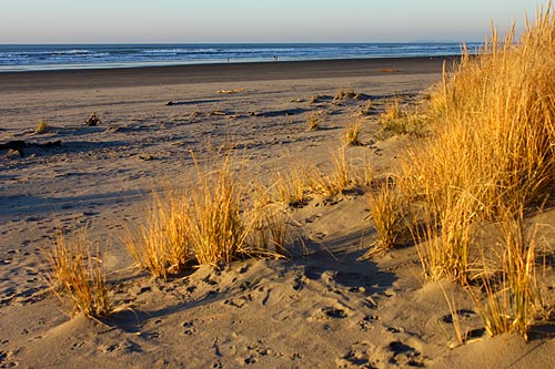
(Seaside, Oregon) – The legendary tourism hotspot of Seaside has shifted and changed in some remarkable ways in recent history. It has received a few major makeovers. Starting 300 years ago with a massive natural disaster, up to two large-scale geological changes in recent decades, the north Oregon coast family fun centerpiece used to look much different. (Photo above: Seaside dunes and its wide beach did not exist until 100 years ago).
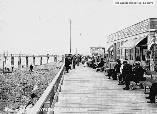
Perhaps one of the most impressive – if not shocking – facts about the layout of Seaside is that there used to be a lot less of it. Until about 100 years ago. And it was a rocky, stony beach, not unlike what the cove area is now – or like Bayocean or or Arch Cape. (Above: Seaside's boardwalk and pier, 1908. Historical photo courtesy Seaside Museum).
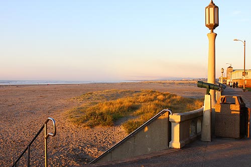
Until about 1917, the surf was 300 feet or so closer to the vegetation line, or what was then still the boardwalk (the Prom was built around 1920).. Thanks to the completion of the south jetty at the Columbia River, some 300 feet of sandy beach was created, not only elongating the beach but making it much more covered in sand (and thus more comfortable to sit on).
Construction began on the first jetty on the south side of the Columbia River in 1885, and the system was completed by 1917. Creating these structures shifts the currents drastically and causes sediment to build up nearby, sometimes for tens of miles in either direction. In this case, the south jetty (at Warrenton's Fort Stevens State Park) affected sand distribution all the way down to Seaside, some 20 miles.
Even more impressive, it added a few square miles of sandy ground to the marshland that would later become Fort Stevens State Park.
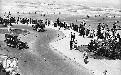
Because of all this, Seaside is currently known as one of the safest beaches on the Oregon coast, even during storms, as it is broad enough to let you keep a distance from large waves. There are also a lot of eyes on those beaches, with all the hotel rooms and businesses on that oceanfront stretch. (Above: Seaside's Prom in 1921 or so. Below: the Prom and beach today. Note how much wider the beach is now. Historical photo courtesy Seaside Museum).
.
The famed “Cove” area of Seaside, at its southernmost tip, is also a curious shocker, but more recently so. Until about 1987, there was a lot less of that shoreline too.
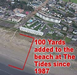 Tom Horning, a local geologist, said a huge a landslide coming down from Tillamook Head that year added some 100 yards of beach. If you head to Avenue U these days, near the Cove, you'll walk a few hundred feet through soft sand and puffy dunes to get to the water. That walk used to be much shorter.
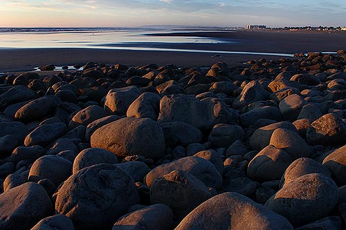
Horning explains that Tillamook Head sometimes drops tons and tons of rocky material into the sea, which periodically changes the landscape. Boulders and rocks from this particular landslide slowly filled in the cove area, extending one part outward by hundreds of feet.
First, a new spit was formed by the rocks for a while, which locals used with glee to catch loads of fish. Fairly quickly, that space between the spit and the land filled up, creating an enormous dead tide pool for a time. Eventually, sand and rocks filled all that in, as well as down the beach.
Horning points to the building at the cove that is the beachfront section of The Tides by the Sea hotel. “Back when they first built this, the sea practically came right up to the building,” Horning said. “They had boulders and rip rap there to keep it away. After 1987, 100 yards of beach was created in front of that area.”
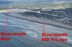 If you want to get a glimpse of just how serious the big tsunami will be (the one predicted to hit the Oregon coast within the next 100 years or so), you need only look at at the Necanicum River in Seaside. Then, look at the famed Turnaround, about a half mile south. Back before the massive tsunami of 1700, those two were in the same place.
That is to say, that great big inundation ripped apart the coastal landscape so much it moved the river mouth a whole half mile to the north, according to Horning. The river mouth used to be where the Seaside Turnaround is now. Seaside, Oregon Hotels in this area - Where to eat - Maps - Virtual Tours
More About Seaside Oregon Coast hotels, lodging.....
More About Oregon Coast Restaurants, Dining.....
Cannon Beach Lodging
Nehalem Bay Lodgings
Manzanita Hotels, Lodging
Three Capes Lodging
Pacific City Hotels, Lodging
Lincoln City Lodging
Depoe Bay Lodging
Newport Lodging
Waldport Lodging
Yachats Lodging
Oregon Coast Vacation Rentals
Oregon Coast Lodging Specials
LATEST Related Oregon Coast Articles
Milo Graamans on May 13 at a special benefit; Fiddle Express on May 16. Newport events
South Oregon Coast Landmark Under the Knife: Bandon's Face Rock Viewpoint Clo...
Set to reopen on May 23, parking lot and restroom closed, Depoe Bay, Cape Foulweather. Travel tips
Surprise Oregon Coast Accesses at Yachats' Northern, Outer Edges
Glorious discoveries include where Yachats changes from sand to rock. Travel tips
Washington Coast Gets Another Green Light for Razor Clamming, April 26 - May 3
Long Beach, Copalis, Twin Harbors and Mocrocks. Washington events
Gnarly Lancetfish Found on N. Oregon Coast - and No, It's Not a Barracuda
Found in Seaside still intact, they were able to examine it. Marine sciences, Seaside Aquarium
Coast Guard Medevacs Patient from Cruise Ship Off South Oregon Coast - Video
15 miles from Coos Bay, the man was taken to a local hospital in good condition. Beach safety
Spring's Weird Things Along Washington, Oregon Coast
Whale burps, ocean burps, freaky skeletons, mermaid purses, live eggs, more. Marine sciences
Two Paddle Boarders Rescued at S. Oregon Coast's Secret Beach
One had a broken arm and hypothermia. Near Brookings. Beach safety
Back to Oregon Coast
Contact Advertise on BeachConnection.net
All Content, unless otherwise attributed, copyright BeachConnection.net Unauthorized use or publication is not permitted


