Severe Oregon Coast Range Snow Watch; High Winds, Flooding on Coast
Published 02/11/2019 at 3:23 PM PDT
By Oregon Coast Beach Connection staff
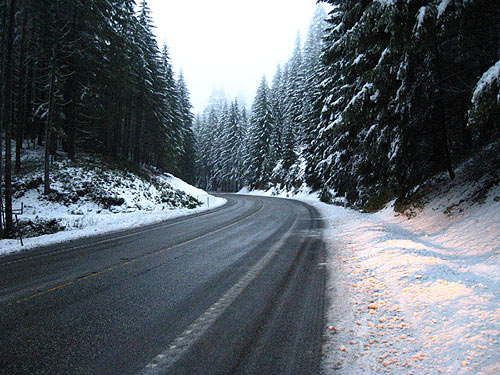
(Oregon Coast) - In a sudden change since early Monday, a winter storm watch is now in effect for the Oregon Coast Range from 6 p.m. Monday through late Tuesday night. Accumulations may be up to two to six inches – although the National Weather Service is saying confidence is still low about that kind of event.
Includes exclusive listings; some specials in winter
In Cannon Beach:
Includes rentals not listed anywhere else
In Manzanita, Wheeler, Rockaway Beach:
Some specials for winter
In Pacific City, Oceanside:
Some specials for winter
In Lincoln City:
Some specials for winter
In Depoe Bay, Gleneden Beach:
Some specials for winter
In Newport:
Look for some specials
In Waldport
Some specials for winter
In Yachats, Florence
Some specials for winter
The Oregon coast is also under a high wind warning and a flood watch until late Tuesday. Then, huge waves arrive over the weekend.
Much shifted in the overnight hours with the National Weather Service’s (NWS) predictions. At 3 a.m., the agency was still saying snow events would be over for the region, which included Portland and the Willamette Valley. But early this morning all that changed.
The NWS is saying heavy snow is possible in the coast range, with as much as a foot falling on the higher elevations. Travel could get difficult and the NWS said you should carry chains if heading over the passes to the Oregon coast, especially early Tuesday.
Still, confidence is not high this will happen.
“There is high confidence in heavy precipitation tonight and Tuesday, but low confidence for the snow levels,” the NWS said. “Rainfall totals of 1 to 4 inches are possible for the coast and inland valleys. The combination of low-elevation heavy rain and snowmelt may result in localized small stream and urban flooding.”
The current forecasts from the NWS for the Oregon Coast Range indicate rain and then snow after 7 p.m. tonight. Much the same forecast is for Tuesday, although little to no accumulation is expected. Some more snow is possible before 10 a.m. on Wednesday, then the pattern returns to straight rain for the week.
Overnight lows only get to 31 or 30, while daytime highs are around 41.
A high wind warning goes into effect for the Oregon coast from 4 p.m. to 10 a.m. Tuesday.
“South to Southwest 25 to 40 mph with gusts to 65 mph,” the NWS said. “Strongest wind on beaches and headlands.”
Minor flooding is possible along some of the rivers in northwest Oregon, from the coast to Portland. There is a flood watch in effect from 7 p.m. to late Tuesday night.
“Heavy precipitation Monday night through Tuesday will likely fall as rain at lower elevations, although uncertainty remains about the snow level Tuesday morning,” the NWS said. “Rainfall totals of 1 to 4 inches are possible for the coast and inland valleys. The combination of low-elevation heavy rain and snowmelt may result in localized small stream and urban flooding, along with flooding along a few rivers and creeks in the Willamette Valley Tuesday and Tuesday night.”
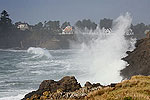
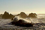
Some fairly heavy wave action is headed for the Oregon coast as well. Monday will see combined seas of more than 15 feet at times, lowering a bit to 13 feet and then a bit lower than that on Wednesday.
Thursday, they pick up again to around 14 feet, and then some really big waves swoop in on Friday at around 23 feet – possibly around 27 feet. They lower to about 21 feet on Saturday. This could spell some beach warnings or advisories over the weekend, but certainly good stormwatch action along rocky spots like Yachats, Depoe Bay, Oceanside and south of Cannon Beach.
See Oregon Coast Weather - Oregon Coast Traffic Conditions.
Oregon Coast Lodgings for this event - Where to eat - Maps - Virtual Tours
 Open Nest Vacation Rentals. Dozens of vacation homes, all fully furnished and beachfront, some pet friendly. Each home w/ gas or wood fireplace, cable TV, and free movie rentals. Sleeps four to 12 people. . 1-877-549-2632 or 503-965-5776. 33105 Cape Kiwanda Dr., Pacific City, Oregon. www.shorepinerentals.com
 Inn at Haystack Rock. 3 blocks from downtown, only a block from beach. Garden courtyard with a Spanish-style fountain. Private patios, barbecue area, free wi-fi, flatscreen TV with DVD player, large, complimentary DVD library. Some host sleep two or three, one hosts six. 487 S. Hemlock. Cannon Beach . 800-559-0893. Inn at Haystack Rock website here.
Cannon Beach Lodging
Nehalem Bay Lodgings
Manzanita Hotels, Lodging
Three Capes Lodging
Pacific City Hotels, Lodging
Lincoln City Lodging
Depoe Bay Lodging
Newport Lodging
Waldport Lodging
Yachats Lodging
Oregon Coast Vacation Rentals
Oregon Coast Lodging Specials
More About Oregon Coast hotels, lodging.....
More About Oregon Coast Restaurants, Dining.....
LATEST Related Oregon Coast Articles
The sixth in the NW in three weeks; early indications suggest it may have been undernourished. Marine sciences
Now Begins the 'Season of Satellites' Above Oregon, Washington: Summer's Surr...
Not even counting meteors, these satellite trains can create wild colors and streaks in the sky. Astronomy, weather. Brookings events, Gold Beach events, Port Orford events, Coos Bay events, Bandon events, Florence events, Yachats events, Newport events, Lincoln City events, Rockaway Beach events, Manzanita events, Cannon Beach events, Seaside events, Astoria events
7-Day Parking Meters Return to Central Oregon Coast Town, and Now to Nye Beac...
Newport?s Bayfront will charge all week, and the Nye Beach Turnaround will now do the same. Travel tips, traffic
87th Annual Azalea Fest Readies Its Return for Memorial Day Weekend on S. Ore...
Brookings brings back the long-running festival over Memorial Day weekend, May 22?25. Brookings events
Harrowing Accident Scene on S. Oregon Coast Turns Into Search for Driver and ...
Sheriffs found an empty vehicle and searched nearly 24 hours before locating the driver. Traffic
Another Dead Whale Stranding, This Time Near Yachats on Central Oregon Coast
Reports differ on whether it was alive at first; scientists are examining the carcass. Marine sciences
Washington Coast Cleanup Scours Inner and Outer Coast, April 25
Volunteers are needed along the outer coast and throughout the Salish Sea. Washington coast events
4th of July at N. Oregon Coast's Sand Lake Now Requires Pre-Sales for Camping...
Congestion and overcrowding in recent years at Sand Lake Recreation Area near Pacific City. Traffic, travel tips
Back to Oregon Coast
Contact Advertise on BeachConnection.net
All Content, unless otherwise attributed, copyright BeachConnection.net Unauthorized use or publication is not permitted


