Snow Alerts Vary Around Oregon, Washington, Coastlines - Icy Roads Possible
Published 02/04/25 at 8:09 p.m.
By Oregon Coast Beach Connection Staff
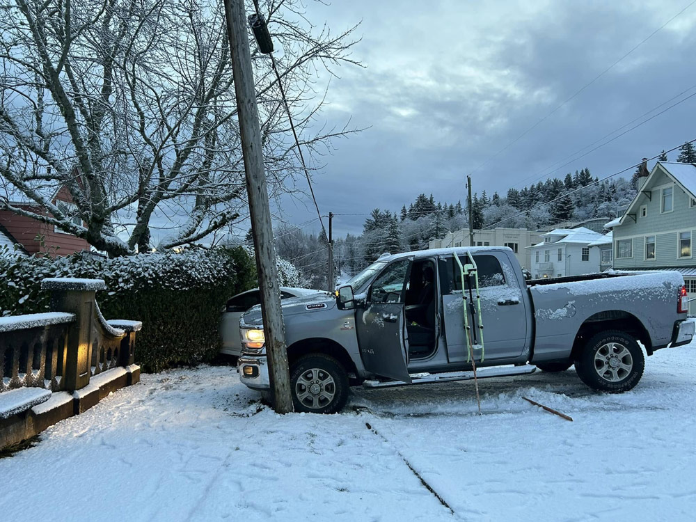
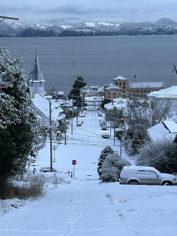
(Portland, Oregon) – Oregon and Washington weather warning maps are lighting up like a Christmas tree right now, as the National Weather Service (NWS) has almost all of Oregon under one kind of snow alert or another. Southwest Washington is also under similar watches or warnings. (Above: a traffic mishap in snowy Astoria this week - Astoria Police photo)
Includes exclusive listings; some specials in winter
In Cannon Beach:
Includes rentals not listed anywhere else
In Manzanita, Wheeler, Rockaway Beach:
Some specials for winter
In Pacific City, Oceanside:
Some specials for winter
In Lincoln City:
Some specials for winter
In Depoe Bay, Gleneden Beach:
Some specials for winter
In Newport:
Look for some specials
In Waldport
Some specials for winter
In Yachats, Florence
Some specials for winter
Southern Oregon Coast Hotels / Lodgings
Reedsport to Brookings, places to stay; winter deals
With the Oregon and Washington coast getting large amounts of snow the last couple of days, it's been a bit topsy turvy. Usually inland areas get more snow. It's generally all melted off later in the day, but some traffic issues occurred – including one crash in Astoria.
The Oregon Coast Range and Willapa Hills are under a winter storm warning, which is likely to create traffic issues from the coastline to inland towns. Just about the entire rest of the state – except for a few areas – are under winter weather advisories. That includes Portland, Vancouver, Bend, Eugene, Sutherlin, Salem, as well as coastal towns such as Seaside, Coos Bay, Cannon Beach, Newport, Lincoln City, Bandon and even Brookings.
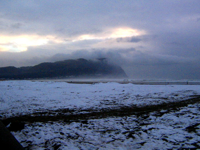
In fact, Brookings saw some rather stunning snow Monday.
“There will be scattered snow showers producing 1+ inches of snow ranging from Tuesday, February 4th through Thursday, February 6th,” the NWS said. “Some areas will see at least one inch starting now, whereas some areas could not see an inch or more of snow until early Thursday morning. There is increasing confidence for accumulating snow below 500 feet elevation Tuesday night (Feb 4) into Wednesday morning (Feb 5). ”
Snow
in Astoria tuesday morning - Astoria Police photo
Snow in most areas is expected to melt later in the day. However, the greatest hazards exist overnight tonight, into Wednesday morning and overnight Thursday, as any moisture left on the streets will likely freeze and create slippery roads in the morning.
This all depends on where the snow showers happen, however. For example, one part of Portland or the coast could get more while other sections get less.
“Snow is expected late tonight through Wednesday across southwest Washington and northwest Oregon,” the NWS said. “Snow showers will be geographically dependent, and areas that receive more showers will see higher snow amounts.”
Oregon Coast Beach Connection (file photo)
A Roundup:
Winter Storm Warning: North Oregon Coast Range and Willapa Hills, with snow accumulations between 1 and 7 inches.
Lower elevations of the Coast Range are under winter weather advisories.
Winter Weather Advisories in effect from now through midday or late Wednesday. They have been issued for:
South Oregon coast areas of Reedsport through Brookings. All of north and central Oregon coast from Florence to Astoria. Southern Washington coast from Long Beach to Raymond. Washington Coast Weather - Oregon Coast Weather
Northwest Oregon / southwest Washington: including Vancouver, Portland, Willamette Valley. This includes towns such as Molalla, Ridgefield, Longview, McMinnville, Oregon City, Albany, Eugene, Happy Valley, Woodburn, La Center and more.
The Columbia River Gorge: including SR 14, Upper Hood River Valley, Bonneville and Hood River, among others.
The entirety of the Cascades and areas like Roseburg are under a winter storm warning, while Bend, John Day and Burns are under the advisories. - Inland Oregon Weather
Oregon Coast Hotels in this area - South Coast Hotels - Oregon Coast Vacation Rentals - Where to eat - Maps - Virtual Tours


Oregon Coast Vacation Rentals
Oregon Coast Lodging Specials

More About Oregon Coast hotels, lodging.....
More About Oregon Coast Restaurants, Dining.....


 Andre' GW Hagestedt is editor, owner and primary photographer / videographer of Oregon Coast Beach Connection, an online publication that sees over 1 million pageviews per month. He is also author of several books about the coast.
LATEST Related Oregon Coast Articles
Bloom Newport Hits Streets of Oregon Coast Town with Music, Fun and the Inven...Saturday, May 31 it expands to the street of Nye Beach. Newport events
Two Paddle Boarders Rescued at S. Oregon Coast's Secret Beach
One had a broken arm and hypothermia. Near Brookings. Beach safety
Washington Coast Gets Another Green Light for Razor Clamming, April 26 - May 3
Long Beach, Copalis, Twin Harbors and Mocrocks. Washington events
Astronomy News, Updates from Oregon Coast, Washington Coast
Astronomy from a Pacific Northwest Perspective: stargazing, space science, meteors, aurora borealis, interstellar phenomena, surprises in the skies. Sciences, weather
Winema Wayfinding Point or Pacific Crest Wayside: an Oregon Coast Puzzle
Between Neskowin and Pacific City sits a viewpoint with two names. Travel tips
Astoria's Crab, Seafood, Wine Fest Floods N. Oregon Coast with Yumminess in A...
April 25 to 27 at the Clatsop County Fairgrounds. Astoria events, Cannon Beach events
Be Jeweled Returns to Central Oregon Coast, Newport's Dazzling, Arty Jewelry ...
Saturday, May 10, from 10 AM to 4 PM featuring more than 2,000 pieces. Newport events
Rugged Central Oregon Coast This Summer: Guided Pontoon Boat, Tidepool and Ca...
Lincoln City events every week: guided boat, tidepools gatherings, tours of Cascade Head. Lincoln City Exploriences. Click for schedule
Back to Oregon Coast
Contact Advertise on Oregon Coast Beach Connection
All Content, unless otherwise attributed, copyright © Oregon Coast Beach Connection. Unauthorized use or publication is not permitted

Oregon
Coast Hotels
S. Coast Hotels
Astoria/Warrenton Hotels
Seaside Hotels
Cannon
Beach Hotels
Nehalem Bay Lodgings
Manzanita Hotels, Lodging
Rockaway Beach Hotels
Three Capes Lodging
Pacific City Hotels, Lodging
Lincoln
City Lodging
Depoe
Bay Hotels
Newport Hotels
Waldport Lodging
Yachats
Hotels
Florence Hotels
Reedsport Hotels
Coos Bay Hotels
Bandon Hotels
Port Orford Hotels
Gold Beach Hotels
Brookings Hotels
Oregon
Coast Vacation Rentals
Oregon
Coast Lodging Specials
South Coast Hotels
Dining
Guide
Seaside
Cannon
Beach Dining
Manzanita,
Rockaway, Wheeler Dining
Pacific
City, Oceanside, Netarts, Tierra Del Mar Restaurants
Tillamook
Bay Restaurants, Dining
Lincoln
City Dining, Restaurants
Depoe
Bay Restaurants, Dining
Newport Restaurants, Dining
Waldport,
Yachats Restaurants, Dining
Florence Restaurants, Dining
Restaurant
Reviews
Coast
Events Calendar
Astoria
Seaside,
Cannon Beach Calendar
Manzanita,
Rockaway Events
Tillamook,
Pacific City Calendar
Lincoln
City Events Calendar
Newport,
Depoe Bay Events Calendar
Yachats Events Calendar
Oregon Coast Complete Guides every beach access, attraction
Search for Oregon Coast Subjects, Articles
Explore Every Beach Spot


News Headlines from All Over Oregon Need to scan Oregon headlines? Constantly updated news from all over Oregon: a comprehensive, up-to-the-minute display of news headlines from a variety of media
Oregon Coast Oceanfront Lodging, Hotels, Rentals