What Created Ten Tornado Warnings for the Oregon, Washington Coast Last Week?
Published 10/19/2016 at 9:11 PM PDT
By Oregon Coast Beach Connection staff
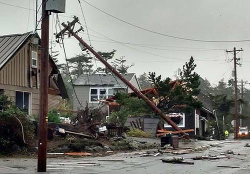
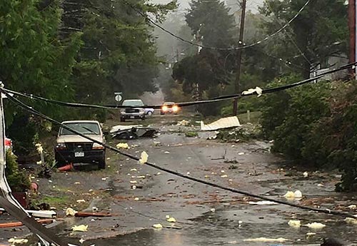
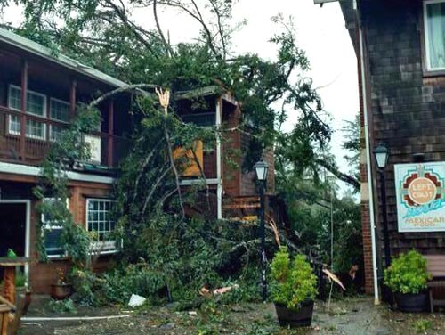
(Manzanita, Oregon) – October 14 is a day that will live in infamy for residents of Manzanita, as a tornado touched down there and lashed the town to the tune of 128 buildings damaged. Another small water spout turned into a brief tornado at Oceanside, causing no damage. Meanwhile, a record ten tornado warnings were issued for the northern Oregon coast and southern Washington. (Photo courtesy Amy VanDyke, Sunset Vacation Rentals).
It's all something the region has never experienced before. Tornadoes almost never happen on the coast. (See Two Tornadoes on Oregon Coast; Manzanita Severely Damaged, Video)
What conditions created this rare occurrence? According to Colby Neuman, a meteorologist with the National Weather Service (NWS) office in Portland, the answer is quite complex.
In essence, the combination of a lot of different elements came together, some of them quite unusual. Neuman called the storm itself “rare,” in that it was a low pressure system that coincided with a storm that was atypically strong for this time of year, making things so much more unstable.
“This storm is rare in the sense that it is one of the stronger low pressure systems we've had off the Washington coast this early in the season,” Neuman said. “Rare in the sense that it was a combo of warm ocean temperatures with a strong wind field, and the placement of the low pressure. All those coming together is not something we've seen very often this early in the season.
“It's more than likely this helped in this regard in making the situations so favorable for it to develop. We might get a low like this, but if we get it in January the ocean is a lot cooler so there isn't as much instability.”
To understand this fully, you need to go back a bit.
The first clue something was different is that a record ten tornado warnings were issued by the NWS on that morning: the most they've ever issued in one day is three. Neuman said warnings were handed down for three counties: Pacific County (on the Washington coast), and for Tillamook and Clatsop counties.
One of the first tornado warnings issued was at 8:16 a.m. for the towns of Manzanita, Rockaway Beach, Elsie, Wheeler, Necanicum, Mohler and Hamlet. Some of those villages are up Highway 53 and close to Highway 26.
In Manzanita, that now-infamous tornado hit two minutes later at 8:18 a.m.
Another tornado warning was issued at 8:41 a.m. for roughly the same part of the north Oregon coast, but this time for Garibaldi, Manzanita, Cape Meares, Rockaway Beach, Bay City, Wheeler, Nehalem and Mohler. Nothing materialized there.
Neuman said each of the three counties had more than one tornado warning. Sometimes they were for more than one county at once and then expired, with yet another following from a different storm.
The Doppler radar systems the NWS utilizes for the Oregon coast are around Scappoose, Oregon, and just north of Grays Harbor in Washington. These, Neuman said, could see that storm cells were rotating, and how fast the objects were approaching.
These objects – essentially systems of clouds and rain – are what they watch. Neuman said the low pressure system interacted with them.
“It's a cold unstable environment,” Neuman said. “And the more wind that there is sort of wrapping around that low pressure, the more you tend to get a pattern of storms rotating. And in this case, the winds were on the very high side for what we get this time of year, and the low pressure was in the right place where we have what we need to basically get a combination of a turning of the winds with height.”
Neuman explained that at that hour, southerly winds were right near the surface, and just a thousand feet or two higher the winds were more out of the northwest. Meanwhile, a little higher than that and they were coming more out of the west.
“And that gets these showers and storms to rotating and spinning,” he said. “And that actually moves down out of the clouds in the form of a tornado.”
Now, throw in the element of milder ocean temperatures this time of year and you have a recipe for tornado action. October is normally when the Oregon coast is coming off its “second summer,” the warmest time of the year in the area. One of the big factors there is that the ocean has been warmed up all summer, only beginning to cool now.
So with warmer ocean temps, a low pressure area, wind directions that vary greatly by elevation and stronger winds than usual for October, you get the kind of instability that can create Friday's crazy conditions.
Neuman said all this was the ideal setup for twisters and water spouts. The warmer ocean adds to the instability of the air and allows it to rise more on its own. This wouldn't happen in January, February or March when the ocean is colder.
“A lot of the coastal tornadoes have happened in the late fall and early winter,” Neuman said.
The Manzanita tornado was classified as an EF2, the third strongest category (and fourth from the highest in damage). The one at Oceanside is considered an EFU – meaning EF Unknown. That one damaged nothing and left virtually no traces, although Neuman said it's believed this twister did make more landfall than previously thought, meandering over a hillside before dissipating.
Oregon Coast Hotels in these areas - Where to eat - Maps - Virtual Tours.
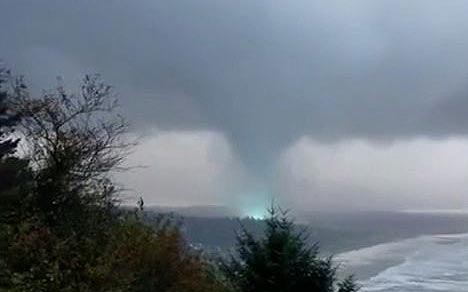
Still shot from Tyler Ryals
More About Oregon Coast hotels, lodging.....
More About Oregon Coast Restaurants, Dining.....
Cannon Beach Lodging
Nehalem Bay Lodgings
Manzanita Hotels, Lodging
Three Capes Lodging
Pacific City Hotels, Lodging
Lincoln City Lodging
Depoe Bay Lodging
Newport Lodging
Waldport Lodging
Yachats Lodging
Oregon Coast Vacation Rentals
Oregon Coast Lodging Specials
LATEST Related Oregon Coast Articles
Happy ending for the elephant seal with tales from Oceanside to Long Beach. Marine sciences
Winema Wayfinding Point or Pacific Crest Wayside: an Oregon Coast Puzzle
Between Neskowin and Pacific City sits a viewpoint with two names. Travel tips
Oregon Wildlife Experts: Leave Animal Babies Alone in Forests, Coast
People with the right intentions can do the worst. Marine sciences
Authorities Seek Suspect Who Stabbed Baby Seal on Oregon Coast
Attack happened in Neskowin: see the police drawing. Weather
Cannon Beach Sandcastle Contest 2025: N. Oregon Coast Tradition Happens June 21
Started in '64 after a tsunami hit town. Newport events Manzanita events, Cannon Beach events, Seaside events, Astoria events
Florence Rhododendron Festival Hits Florence and Central Oregon Coast Soon
May 15 to 18, food vendors, a carnival, parades and even a classic car cruise. Florence events, Newport events Manzanita events, Cannon Beach events, Seaside events, Astoria events
Oregon's Tillamook Coast Hosts Rigorous Kayaking, Hiking Events in May
Netarts events May 17 and 31; Manzanita events May 14
Above Oregon / Washington Coast in May: Meteors Peak, Galaxy Disappears - and...
A sky full of possibilities this month, including a star that might explode. Sciences, astronomy
Back to Oregon Coast
Contact Advertise on BeachConnection.net
All Content, unless otherwise attributed, copyright BeachConnection.net Unauthorized use or publication is not permitted


