World War II Radar Bunker at Cape Arago Near Coos Bay: Oregon Coast's Station B-28
Published 03/11/25 at 6:55 p.m.
By Oregon Coast Beach Connection Staff
(Coos Bay, Oregon) – As World War II began, it abruptly meant major changes for everyone in the U.S. - including the Oregon coast. Here, it meant more than rations, however. Military guarding our shores became a common sight, with soldiers quite literally patrolling on foot on beaches from California to Washington, and beyond that various aircraft moved up and down the shoreline to keep an eye out. (Photo Steve Greif / Coos History Museum)
Includes exclusive listings; some specials in winter
In Cannon Beach:
Includes rentals not listed anywhere else
In Manzanita, Wheeler, Rockaway Beach:
Some specials for winter
In Pacific City, Oceanside:
Some specials for winter
In Lincoln City:
Some specials for winter
In Depoe Bay, Gleneden Beach:
Some specials for winter
In Newport:
Look for some specials
In Waldport
Some specials for winter
In Yachats, Florence
Some specials for winter
Southern Oregon Coast Hotels / Lodgings
Reedsport to Brookings, places to stay; winter deals
World War II also meant quite a few secret installations along this coastline, or even just semi-secretive. Patrol base camps, runways, forts of one kind or another and actual radar stations housed in secret bunkers dotted the region.
Tracking down that kind of history is not easy, and photos of local installations are downright scarce. Back then, no one was allowed to snap pics of their army buddies lined up in front of whatever building they were occupying. Even relatively innocuous shots were not permitted: such as the home in Lincoln City that was rented out by soldiers to use a submarine lookout, so sadly no photo of that home with its military aspects exist.
Sometimes the U.S. Army built forts and bunkers – and those are a touchy subject. There were many of these along the Oregon coast, and almost no photos are left of them.
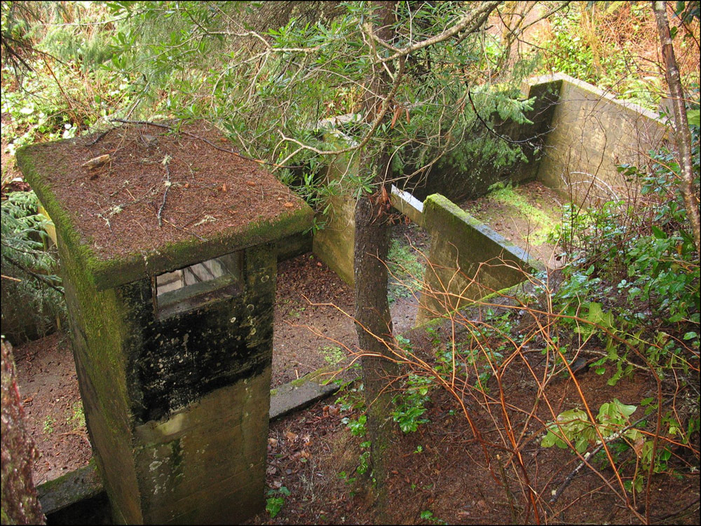
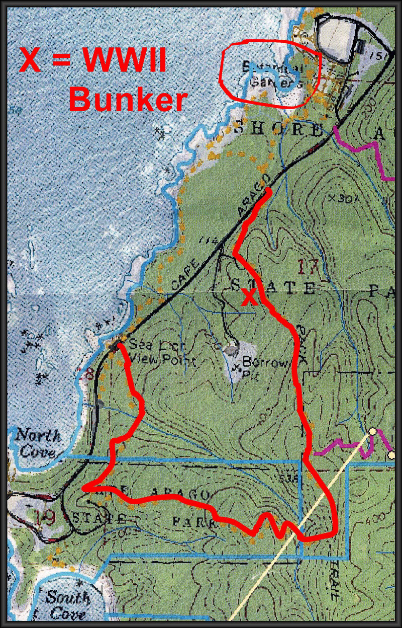
Case in point: the old military radar bunker at Cape Arago near Coos Bay. Hidden somewhat deep in the lush greens of the south coast hotspot and not far from the parking lot, there is a set of concrete ruins. They've almost got an old castle vibe about them.
It's about a quarter mile from the main road, with the remainder of the Cape Arago trail beyond that.
Steve Greif / Coos History Museum
This was called Station B-28, utilizing the SCR-270 radar equipment technology at the time. The mission was to not just look for incoming enemy aircraft but also to assist U.S. planes in their patrols and maneuvers.
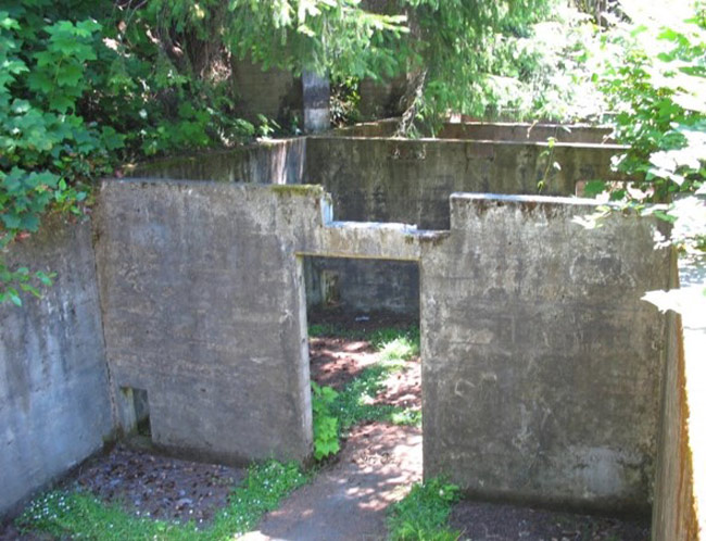
The atmosphere of the place is undeniable, even if it's splattered in colorful graffiti. A host of empty concrete rooms with no roofing give off a cold vibe. Then there's the two vent towers that housed the generators.
Steve Greif / Coos History Museum
All other remnants of its purpose are gone: even the old radar bunker atop Tillamook Head near Seaside gives you some clues as to what it was.
“Very overgrown now but in the 1940s would have been a good lookout,” said Steve Greif, with the Coos Bay History Museum.
He provided some photographs to Oregon Coast Beach Connection and a good deal of information on the old Cape Arago bunker. He said it is east from the Cape Arago Highway and just beyond the Shore Acres entrance.
The bunker of Station B-28 first fired up in 1942, and had loads of of cables running throughout, Greif said. Indeed, you can still see the spaces in the floor where those were laid. On the side of the hill stood the massive antenna for the radar operation.
The massive antenna was on the side of the hill, and in fact much of the operations were built into the hill to protect it from the elements as well as any attack.
Back then, the brush and trees around were much less dense, possibly even cleared out for the base's purpose. However, some amount of natural camouflage was there in the form of a large tree, providing cover for even much of the antenna and those towering exhaust structures – according to FortWiki.
Greif said even now those four operations rooms remain largely intact, which included an officer's room, the room for the equipment itself, and operations rooms for those keeping watch.
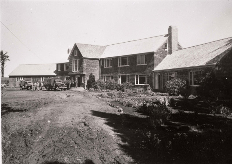
Over at the landmark now known as Shore Acres, the Simpson Mansion (photo at bottom) housed as many as 50 men, which was about half the size of the radar station at Tillamook Head by Seaside, which utilized almost 100.
During wartime, it was common for hotels and major landmarks to become occupied by soldiers. The Astoria Column in Astoria was purely for military personnel during the war years.
Some of the Station B-28 story really begins with Louis J. Simpson, who built the mansion atop Shore Acres after becoming quite wealthy. He was also instrumental in bringing about Highway 101 in the 1910s, which was originally called the Roosevelt Military Highway as World War I and defensive preparations were part of the reasoning behind the roadway.
In the '40s, his mansion joined the war effort.
Coos History Museum photo
“The military took over Simpson's Shore Acres during WWII (he had granted it to Oregon for a state park) and used the home on the cliff as a lookout for possible Japanese submarine, ship, or aircraft activity,” Greif said.
Station B-28 was shut down in 1944, and by 1946 that technology was declared obsolete.
The radar station at Tillamook Head was called J-2-3 (see Mysterious Radar Bunker Atop Seaside's Tillamook Head), and there is another rather hidden radar station near Oceanside.
Oregon Coast Hotels in this area - Coos Bay Hotels - South Coast Hotels - Oregon Coast Vacation Rentals - Where to eat - Maps - Virtual Tours


Oregon Coast Vacation Rentals
Oregon Coast Lodging Specials


More About Oregon Coast hotels, lodging.....
More About Oregon Coast Restaurants, Dining.....


 Andre' GW Hagestedt is editor, owner and primary photographer / videographer of Oregon Coast Beach Connection, an online publication that sees over 1 million pageviews per month. He is also author of several books about the coast.
LATEST Related Oregon Coast Articles
South Oregon's Golden and Silver Falls Park Needs Cleanup Help in MayNear Coos Bay - Saturday, May 18 they need volunteers. Coos Bay events
Christmas in June? Reservations Now Online for S. Oregon Coast's Shore Acres ...
Coos Bay: timed entry and parking reservations are now online. Coos Bay events
Oregon State Parks See Record Visits, Especially on the Coast
Surpassing the previous high in 2021 by approximately 200,000 visits. Weather. Seaside, Cannon Beach, Bandon, Coos Bay, Gold Beach, Manzanita, Rockaway Beach, Newport, Lincoln City, Yachats, Florence
When a Stormwatch Brews: Vantage Points to View the Gnarly Oregon Coast (Part 1)
Like an oceanic Jerry Springer Show in Bandon, Coos Bay, Depoe Bay
Oregon State Parks Day on June 7: Free Parking and Events on Coast, Inland
Hikes, talks, BBQ, disc golf and even astronomy. Sciences, south coast events, Florence events, Astoria events, Seaside events, Cannon Beach events, Manzanita events, Rockaway Beach events, Tillamook events, Garibaldi events, Oceanside events, Pacific City events, Lincoln City events, Depoe Bay events, Newport events, Waldport events, Newport events, Yachats events, Brookings, Coos Bay, Reedsport
Floodwaters Cause Rescues on S. Oregon Coast, Coos County Sheriffs Urge Caution
One rescue required assistance from the US Coast Guard. Weather
Oregon Coast Lost Legends: Gold Mine, Sea Monster to Treasures Debunked, Coos...
Coos Bay's DB Cooper, Gold Myths, Treasure Ship, Imploding Whale. History, sciences
S. Oregon Coast's Liberty Theatre Makes National Register of Historic Places
North Bend theater gets a new lease on life. Coos Bay
Back to Oregon Coast
Contact Advertise on Oregon Coast Beach Connection
All Content, unless otherwise attributed, copyright © Oregon Coast Beach Connection. Unauthorized use or publication is not permitted

Oregon
Coast Hotels
S. Coast Hotels
Astoria/Warrenton Hotels
Seaside Hotels
Cannon
Beach Hotels
Nehalem Bay Lodgings
Manzanita Hotels, Lodging
Rockaway Beach Hotels
Three Capes Lodging
Pacific City Hotels, Lodging
Lincoln
City Lodging
Depoe
Bay Hotels
Newport Hotels
Waldport Lodging
Yachats
Hotels
Florence Hotels
Reedsport Hotels
Coos Bay Hotels
Bandon Hotels
Port Orford Hotels
Gold Beach Hotels
Brookings Hotels
Oregon
Coast Vacation Rentals
Oregon
Coast Lodging Specials
South Coast Hotels
Dining
Guide
Seaside
Cannon
Beach Dining
Manzanita,
Rockaway, Wheeler Dining
Pacific
City, Oceanside, Netarts, Tierra Del Mar Restaurants
Tillamook
Bay Restaurants, Dining
Lincoln
City Dining, Restaurants
Depoe
Bay Restaurants, Dining
Newport Restaurants, Dining
Waldport,
Yachats Restaurants, Dining
Florence Restaurants, Dining
Restaurant
Reviews
Coast
Events Calendar
Astoria
Seaside,
Cannon Beach Calendar
Manzanita,
Rockaway Events
Tillamook,
Pacific City Calendar
Lincoln
City Events Calendar
Newport,
Depoe Bay Events Calendar
Yachats Events Calendar
Oregon Coast Complete Guides every beach access, attraction
Search for Oregon Coast Subjects, Articles
Explore Every Beach Spot


News Headlines from All Over Oregon Need to scan Oregon headlines? Constantly updated news from all over Oregon: a comprehensive, up-to-the-minute display of news headlines from a variety of media
Oregon Coast Oceanfront Lodging, Hotels, Rentals