BEACH
NEWS YOU CAN USE
Geologic Wonders of Oregon Beaches Make Freaky History Lesson By Andre’ Hagestedt
(Oregon Coast) – The fun and frivolity of Oregon’s coast goes deeper than you know – quite literally. Beneath the sands, behind the sea stacks and deep inside the cliffs, what you see on the coast has quite the freaky history. Millions of years ago, the coastline was actually somewhere about Silver Creek Falls, about 100 miles inland. About that time, the fissure beneath the Earth that now produces the fun of Yellowstone National Park was located around what is now the Oregon/Idaho border (tectonic plates beneath us move all the time, and have moved that far in the last 65 million years). Back then, that opening in the crust caused enormous, cataclysmic eruptions the likes we can’t even imagine seeing now. Walls of scorching lava, hundreds of feet high, marched across and scoured the landscape all the way to the sea, where they would end their horrendous, fiery journey in a fit of steam.
This is the cause of many of the basalt structures and headlands you see today on the coast. Often, sea stacks are the remnants of a headland that once stretched out into the sea, but was eroded over time. In some cases, some scructures were created on the sea floor, then emerged from the water as the land throughout the millennia. Many different actions went into each one, and it differs depending on which structure you’re talking about. But in the end, it’s the mix of rock structure, landscape and sea that has the most enduring fascination and enchanting effect on us. The ocean shores are so completely different than the rest of the world we live in – and for good reason. There are so many more different, complex processes going on here that constantly create change in this fluid, sometimes weird environment. Here’s a few examples you may not know about. Depoe Bay’s Spouting Horn
In fact, businesses across the way, such as the Pacific Crown Inn, find they have to wash their vehicles quite frequently because of the constant exposure to salt water flying through the air.
Much of the Depoe Bay area was created by what is called “pillow basalt.” Basalt rock is formed by lava cooling off, solidifying into this kind of black rock. Pillow basalt is the softer edged, slightly roundish rock, made when lava hits the water and steams itself into these smoother shapes. Spouting horns, like this one and those around Cape Perpetua south of Yachats, were formed by cracks in the rocks that were eroded away over the centuries into chasms or tube-like structures, which compress the wave action in just the right way as to cause it shoot upwards. Short Beach, by Oceanside
Until recently, the way down here was precarious and slippery, causing many injuries. But locals got together and created this "stairway of 1000 steps."
Stunning Spot Without A Name
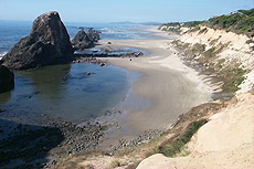
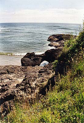
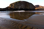
Where the two parts meet, a small basalt arch stretches over and into the sand. Black, giant, jagged rocky slabs contain numerous fissures or cracks, where the tide can do especially spectacular things (you don't want to be around them at these times, however). Huge logs lie all about, testifying to the dangerous power of the waters here. Or, wander up the secret path overlooking the beach and watch it all from above. You may even catch sight of ancient Native American shell middens here, embedded in the sides of the cliffs. History Embedded in the Rocks
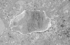
Having seen the fossilized remnants of trees embedded deep in the basalt caves at Silver Creek State Park, I wondered if this was animal or vegetable. Luckily, one of the Oregon Coast's foremost experts on fossils happens to be our columnist. Guy DiTorrice clued me in. He told me it was a "rock scallop, seen from the interior, with the hinge line on the left side. Take a wire brush to it and you'll see the high-sheen polish. The backside (still embedded) will be ruffled design, usually pocked with worm- and clam-drilled holes."
The next logical question then is: how old might this fossil be? Guy said the brownish rock color indicates Astoria Sandstone, which "could be as young as 12 million years old, and as old as 17 million." If that's not cool enough, Guy provided some interesting tips about their modern-day descendants. "They are great eating, have much larger muscles (the meat) than the commercially-harvested swimming scallop cousins." DiTorrice is known as "Oregon Fossil Guy," leading tours around Central Coast beaches to show you how to find all kinds of fossils. www.OregonFossilGuy.com (541) 961-1762. |
||||||||
SPECIAL
SECTIONS |
|||||||||||||
| calendar of events | lewis & clark guide | |||||||||||||
| beach news | weather | |||||||||||||
| editor's adventure blog | |||||||||||||
| columnists: guy ditorrice (general) | peg miller (shopping) | |||||||||||||
| coastal pubcrawl | Important Links | |||||||||||||
| coastal science | kooky coast | |||||||||||||
OR
TAKE THE VIRTUAL TOUR |
|||||||||||||
|
Cannon Beach Ecola Creek Lodge |
BREATHTAKING
CLIFFTOP IN NEWPORT STARFISH
POINT
is located on the Central Oregon Coast - in Newport - and offers
only the finest in luxury condominium lodging. At Starfish Point,
every unit is focused on the beauty of the sea and the beach. |
RELATED STORIES
Oregon Travel Secrets: Weird Science, Spring Rarities on the Coast The 'secret season' and other spectacular oddities abound
Taste-Testing Tourism on the North Oregon Coast Numerous lodging, dining and beach secrets lurk here
'Ocean Burps' Leave Oddities on Seaside Beaches A semi-regular natural occurrance is leaving strange things on the beach
Oregon Tourism Alert: Spring Rarities in Newport Much is new in Newport, especially in the natural world
 Family
Fun
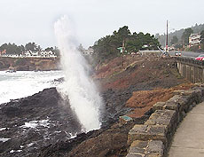 There's
a unique feature to Depoe Bay that few - if any - cities on the
Oregon Coast have. No other coastal town has a spouting horn right
in the middle of downtown, anyway. Here, there are two views of
this magnificent monster from the depths. One, during a spring day
full of lots of breaker action, you can see the spouting horn in
full force. It shoots sea water high into the sky with tremendous
force. Watch out if you're driving by: it's certainly a strange
and slightly silly experience to find yourself having to use your
windshield wipers because a chunk of ocean water just sprayed all
over your car.
 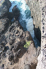 In
this other shot, during a calmer day, you see the culprit. A large
fissure in the basalt rock here compacts the waves and their immense
energy into one huge aerial wallop - something akin to our own version
of Old Faithful (except that it's very random and dependent upon
certain tidal conditions).
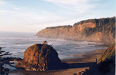 One
of the state's most enthralling hidden spots lies right next to
Oceanside, just west of Tillamook. Look for Radar Rd. along the
back road between Oceanside and Cape Meares, and you'll find the
refurbished entrance to this stunning beach.
 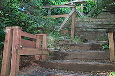 First,
you'll find the bulbous blob at the tide line, resembling the sea
stack at Neskowin to the south. Wander here a bit longer, and you
may see the waterfall coming from the side of the cliff which hosts
the lighthouse. Legends abound here. It's said that at extreme low
tides, there is yet another tunnel visible (like the one through
the cliff in Oceanside). One version of the legend says there may
be two tunnels here.
 Just
south of the county lines between
  In
the summer of 2003, I found this intriguing object embedded in the
rock while wandering the hard-to-traverse rocky chunks of a hidden
beach spot around
  So,
what is a "rock scallop?" I asked. I wondered if this
had something to do with that old B-52's song, "Rock Lobster?"
He said they are non-swimming scallops that attach themselves to
rocks near the shore. He added the scallop is the logo shape used
by Shell Oil Co.
  ASTORIA
 SEASIDE
 CANNON
BEACH
 NEHALEM
BAY
 TILLAMOOK
BAY
 THREE
CAPES LOOP
 LINCOLN
CITY & THE CORRIDOR OF MYSTERY
 DEPOE
BAY
 NEWPORT
 WALDPORT
/ SEAL ROCK
 YACHATS
 UPPER
LANE COUNTY
 FLORENCE